

Please login in order to download photos in full size
If you are not registered, please register for free: www.Free-Photos.biz/register
Please note to download premium images you also need to join as a free member..
You can also save the photos without the registration - but only in small and average sizes, and some of them will have the site's watermark. Please simply click your right mouse button and save the image.
Please login in order to like photos
If you are not registered, please register for free:
Sorry, non-members can download up to 1100 full-size photos per month.
It looks like you have used up your limit.
Free members can download an unlimited number of full-size photos - including the premium free photos.
Join as a member today for FREE! - and download the images without limitations:
www.Free-Photos.biz/membership.php
You can also save the images without the membership - but only in small and average sizes, and some of them may have the site's watermark. Please simply click your right mouse button and save the image.
|
This is a premium free photo
This photo was viewed 3 times and was downloaded in full size 0 times.
This photo was liked 0 times


If you are a member, please login in order to see the source link of the above image.
| Description |
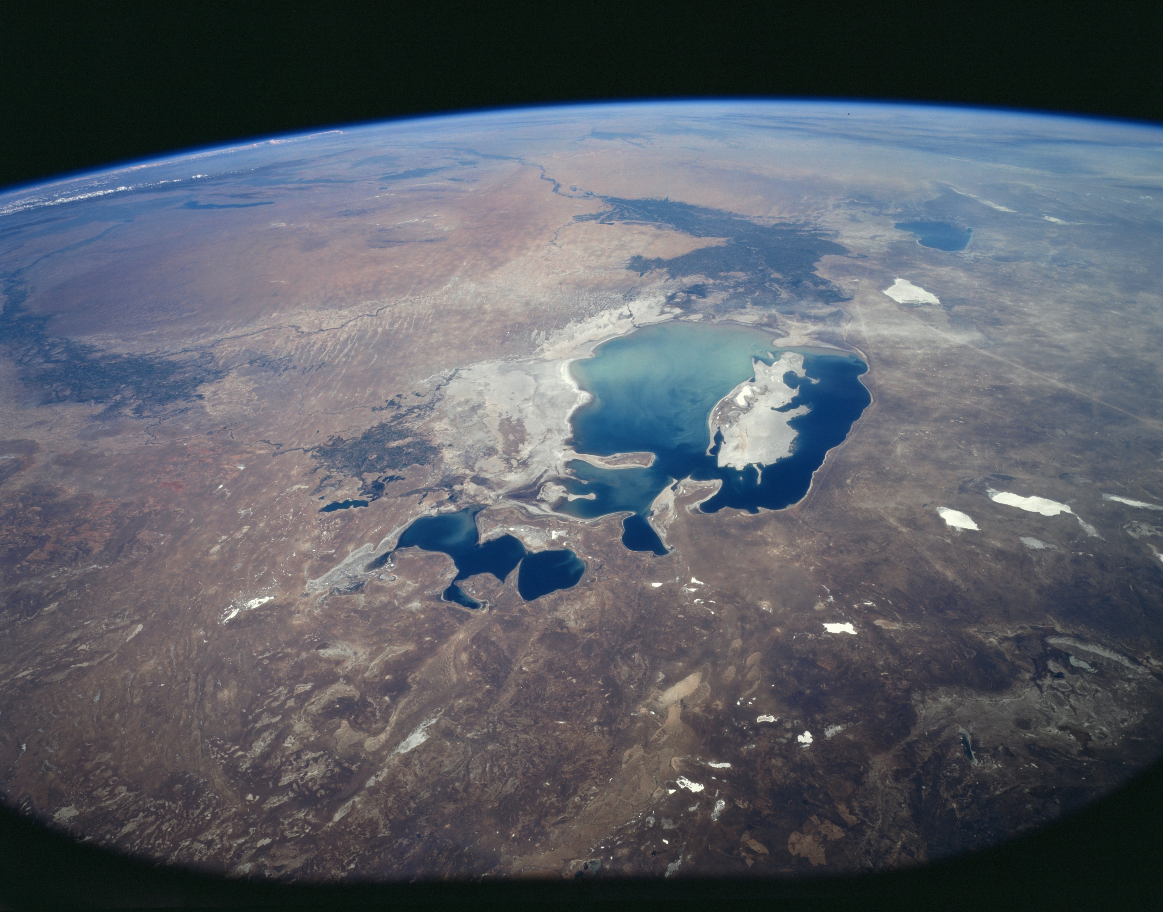
English: STS085-503-119 Aral Sea, Kazakhstan August 1997 Once the fourth largest inland body of water in the world, the Aral Sea, as seen in this southeast-looking view, has shrunk to a fraction of its former size and is now the eighth largest inland body of water in the world. Water has been diverted to cotton irrigation since the late 1950’s from the two rivers that feed the Aral Sea, the Amu-Darya in the south, and the Syr-Darya in the northeast. Pollution of the waters of the Aral Sea from heavy usage of the fertilizers and pesticides has been occurring since the 1960’s. Also occurring was runoff of chemicals used in chemical weapons testing on the Ust-Jurt Plateau (right center of the image) by the former USSR military, which was halted in the mid 1980’s. Salinity of the Aral Sea has tripled since 1960 and nearly twenty species of wildlife and vegetation have become extinct. The Aral Sea, because of the decline, has become two separate bodies of water. The Little Aral Sea, or the northern portion, has begun to rise due to the construction of a small dam to hold the water in and slow the rate of evaporation. Irrigated land in the Syr-Dayra River Valley has declined somewhat in the 1990’s, thus allowing water to reach the Little Aral Sea. The dam in the Little Aral Sea is being constructed and financed by the government of the Republic of Kazakhstan and the small cites that once bordered the Aral Sea. Water levels in the Little Aral Sea have risen by as much as 10 feet (3 meters) during the mid and late 1990’s. With no water reaching the southern Aral Sea through Amu-Darya, some scientists predict that this portion of the sea will disappear by the year 2020.
|
| Date | |
| Source | https://eol.jsc.nasa.gov/sseop/EFS/images.pl?photo=STS085-503-119 |
| Author | NASA |
Licensingedit
_NASA_STS085-503-119.jpg&action=edit§ion=1)
| This file is in the public domain because it was solely created by NASA. NASA copyright policy states that "NASA material is not protected by copyright unless noted". (See Template:PD-USGov, NASA copyright policy page or JPL Image Use Policy.) |
|
 |
Warnings:
|
Original upload logedit
_NASA_STS085-503-119.jpg&action=edit§ion=2)
Transferred from en.wikipedia to Commons by Jsayre64 using CommonsHelper. The original description page was here. All following user names refer to en.wikipedia.
- 2012-05-28 10:06 Lukemcurley 5209×4088× (15090238 bytes) Uploading a public-domain item using [[Wikipedia:File_Upload_Wizard|File Upload Wizard]]
STS085-503-119 Aral Sea, Kazakhstan August 1997 Once the fourth largest inland body of water in the world, the Aral Sea, as seen in this southeast-looking view, has shrunk to a fraction of its former size and is now the eighth largest inland body of water in the world. Water has been diverted to cotton irrigation since the late 1950’s from the two rivers that feed the Aral Sea, the Amu-Darya in the south, and the Syr-Darya in the northeast. Pollution of the waters of the Aral Sea from heavy usage of the fertilizers and pesticides has been occurring since the 1960’s. Also occurring was runoff of chemicals used in chemical weapons testing on the Ust-Jurt Plateau (right center of the image) by the former USSR military, which was halted in the mid 1980’s. Salinity of the Aral Sea has tripled since 1960 and nearly twenty species of wildlife and vegetation have become extinct. The Aral Sea, because of the decline, has become two separate bodies of water. The Little Aral Sea, or the northern portion, has begun to rise due to the construction of a small dam to hold the water in and slow the rate of evaporation. Irrigated land in the Syr-Dayra River Valley has declined somewhat in the 1990’s, thus allowing water to reach the Little Aral Sea. The dam in the Little Aral Sea is being constructed and financed by the government of the Republic of Kazakhstan and the small cites that once bordered the Aral Sea. Water levels in the Little Aral Sea have risen by as much as 10 feet (3 meters) during the mid and late 1990’s. With no water reaching the southern Aral Sea through Amu-Darya, some scientists predict that this portion of the sea will disappear by the year 2020.
Public Domain
| EXIF data: | |
| File name | aralsea_1997__nasa_sts085-503-119.jpg |
|---|---|
| Size, Mbytes | 14.736560546875 |
| Mime type | image/jpeg |
While the copyright and licensing information supplied for each photo is believed to be accurate, Free-Photos.biz does not provide any warranty regarding the copyright status or correctness of licensing terms. If you decide to reuse the images from Free-Photos.biz, you should verify the copyright status of each image just as you would when obtaining images from other sources.
The use of depictions of living or deceased persons may be restricted in some jurisdictions by laws regarding personality rights. Such images are exhibited at Free-Photos.biz as works of art that serve higher artistic interests.
PRIVACY POLICY
By registering your account and/or by subscribing to new and newly rated photographs you agree we may send you the links to photos and we may occasionally share other information with you.
We do NOT disclose your personal data.
