

Please login in order to download photos in full size
If you are not registered, please register for free: www.Free-Photos.biz/register
Please note to download premium images you also need to join as a free member..
You can also save the photos without the registration - but only in small and average sizes, and some of them will have the site's watermark. Please simply click your right mouse button and save the image.
Please login in order to like photos
If you are not registered, please register for free:
Sorry, non-members can download up to 1100 full-size photos per month.
It looks like you have used up your limit.
Free members can download an unlimited number of full-size photos - including the premium free photos.
Join as a member today for FREE! - and download the images without limitations:
www.Free-Photos.biz/membership.php
You can also save the images without the membership - but only in small and average sizes, and some of them may have the site's watermark. Please simply click your right mouse button and save the image.
|
This is a premium free photo
This photo was viewed 1 times and was downloaded in full size 0 times.
This photo was liked 0 times


If you are a member, please login in order to see the source link of the above image.
Summaryedit
| Description |
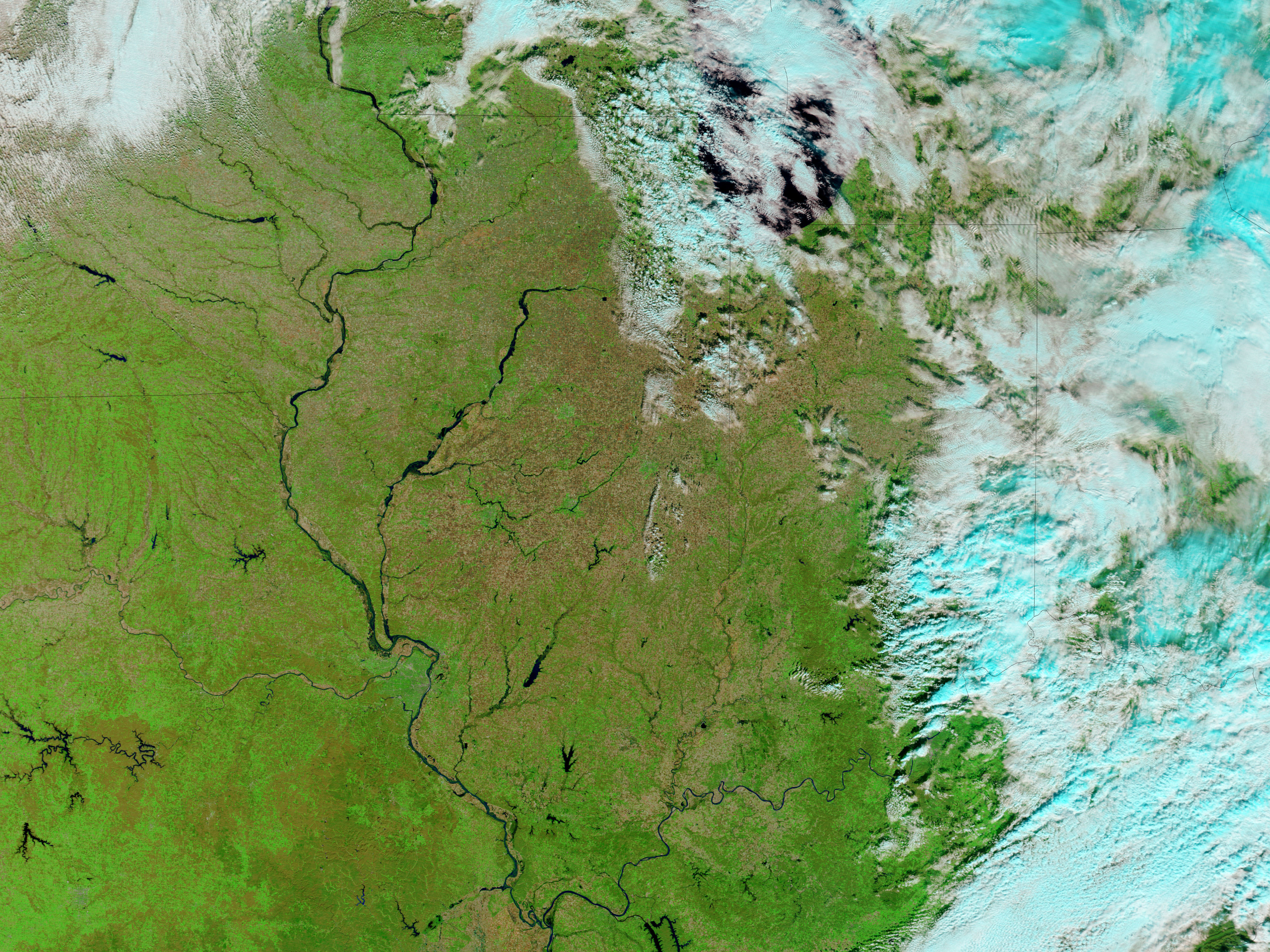
English: This image uses a combination of infra-red and visible light to increase the contrast between water and land. Vegetation appears bright green, water appears navy blue, and clouds appear pale blue-green. the Mississippi River appears swollen near St. Louis. Roughly 175 kilometres north of the city, the Illinois River is especially wide compared to the same area in late October. Due east of St. Louis, Carlyle Lake, along the Kaskaskia River, has also expanded. Smaller tributaries to the Illinois River also appear flooded. East of the Illinois River, vegetation appears less abundant in early November. The change could be the advance of autumn and/or harvesting of agricultural fields, but differences in angle of sunlight (time of day) between the image acquisitions may also play a role.
|
| Date | |
| Source | NASA Image of the Day. Image caputured by the Moderate Resolution Imaging Spectroradiometer (MODIS) on NASA’s Terra satellite. |
| Author | Image courtesy of the MODIS Rapid Response Team, Goddard Space Flight Center. |
| Other versions |
.jpg)
.jpg&action=edit§ion=1)
Licensingedit
.jpg&action=edit§ion=2)
| This file is in the public domain because it was solely created by NASA. NASA copyright policy states that "NASA material is not protected by copyright unless noted". (See Template:PD-USGov, NASA copyright policy page or JPL Image Use Policy.) |
|
 |
Warnings:
|
| Annotations | This image is annotated: View the annotations at Commons |
.jpg)
Public Domain
| EXIF data: | |
| File name | flooding_along_the_illinois_river__after_.jpg |
|---|---|
| Size, Mbytes | 4.8241416015625 |
| Mime type | image/jpeg |
While the copyright and licensing information supplied for each photo is believed to be accurate, Free-Photos.biz does not provide any warranty regarding the copyright status or correctness of licensing terms. If you decide to reuse the images from Free-Photos.biz, you should verify the copyright status of each image just as you would when obtaining images from other sources.
The use of depictions of living or deceased persons may be restricted in some jurisdictions by laws regarding personality rights. Such images are exhibited at Free-Photos.biz as works of art that serve higher artistic interests.
PRIVACY POLICY
By registering your account and/or by subscribing to new and newly rated photographs you agree we may send you the links to photos and we may occasionally share other information with you.
We do NOT disclose your personal data.
