

Please login in order to download photos in full size
If you are not registered, please register for free: www.Free-Photos.biz/register
Please note to download premium images you also need to join as a free member..
You can also save the photos without the registration - but only in small and average sizes, and some of them will have the site's watermark. Please simply click your right mouse button and save the image.
Please login in order to like photos
If you are not registered, please register for free:
Sorry, non-members can download up to 100 full-size photos per month.
It looks like you have used up your limit.
Free members can download an unlimited number of full-size photos - including the premium free photos.
Join as a member today for FREE! - and download the images without limitations:
www.Free-Photos.biz/membership.php
You can also save the images without the membership - but only in small and average sizes, and some of them may have the site's watermark. Please simply click your right mouse button and save the image.
|
Download top free photographs!
This photo was viewed 11 times and was downloaded in full size 3 times.
This photo was liked 0 times


If you are a member, please login in order to see the source link of the above image.
Summaryedit
| Description |
Dansk: Panorama af fuglefjeldet på øen Nunâ øst for Upernavik, syd for Aappilattoq i Grønland. Fotograferet syd for øen under en sejllads til Upernavik Isfjord. På fjeldet, som er 270 m højt yngler gråmåger (Larus hyperboreus). De hvide områder på klipperne er efterladenskaber. De orange områder er gødningselskende laver (formentlig Caloplaca og Xanthoria), som er tilpasset de levevilkår det høje næringsindhold fra efterladenskaberne tilbyder. Billedet er som udgangspunkt skabt i programmet Hugin ud fra 17 billeder arrangeret i tre rækker. De enkelte billeder er taget med et håndholdt kamera (Canon DIGITAL IXUS 800 IS) i en båd der driver lidt med strømmen (for dybt til at kaste anker). Vignetter er søgt fjernet med et tilpasset polynomium i Hugin. Det genererede billede fra Hugin er efterfølgende blevet rektangulært beskåret i GIMP og farveværdikurven er modificeret let for at modvirke overeksponering af visse hvide klippedele. Herefter er billedet Smart Sharpened med en pixel radius på 3,0 og en amount på 30%. Den inverterede kantdetekterede maske er benyttet til at foretage en selektiv Gaussian blur med pixel radius 5.0 i RGB på himlen for at mindske støjen. I det øverste venstre hjørne er "manglende himmel" søgt indsat.
Svenska: Panorama av ön Nunâ öster om Upernavik och syd om Aappilattoq på Grönland, fotot togs syd om ön under en seglats till Upernavik Grönland. Fjället är 270 m över havet och bebos av Måsar. De vita områdena på klipporna är spillning, och de gula är lavar (antagligen Caloplaca och Xanthoria). Bilden bearbetades med Hugin och GIMP, för mer teknisk info läs den engelska texten)
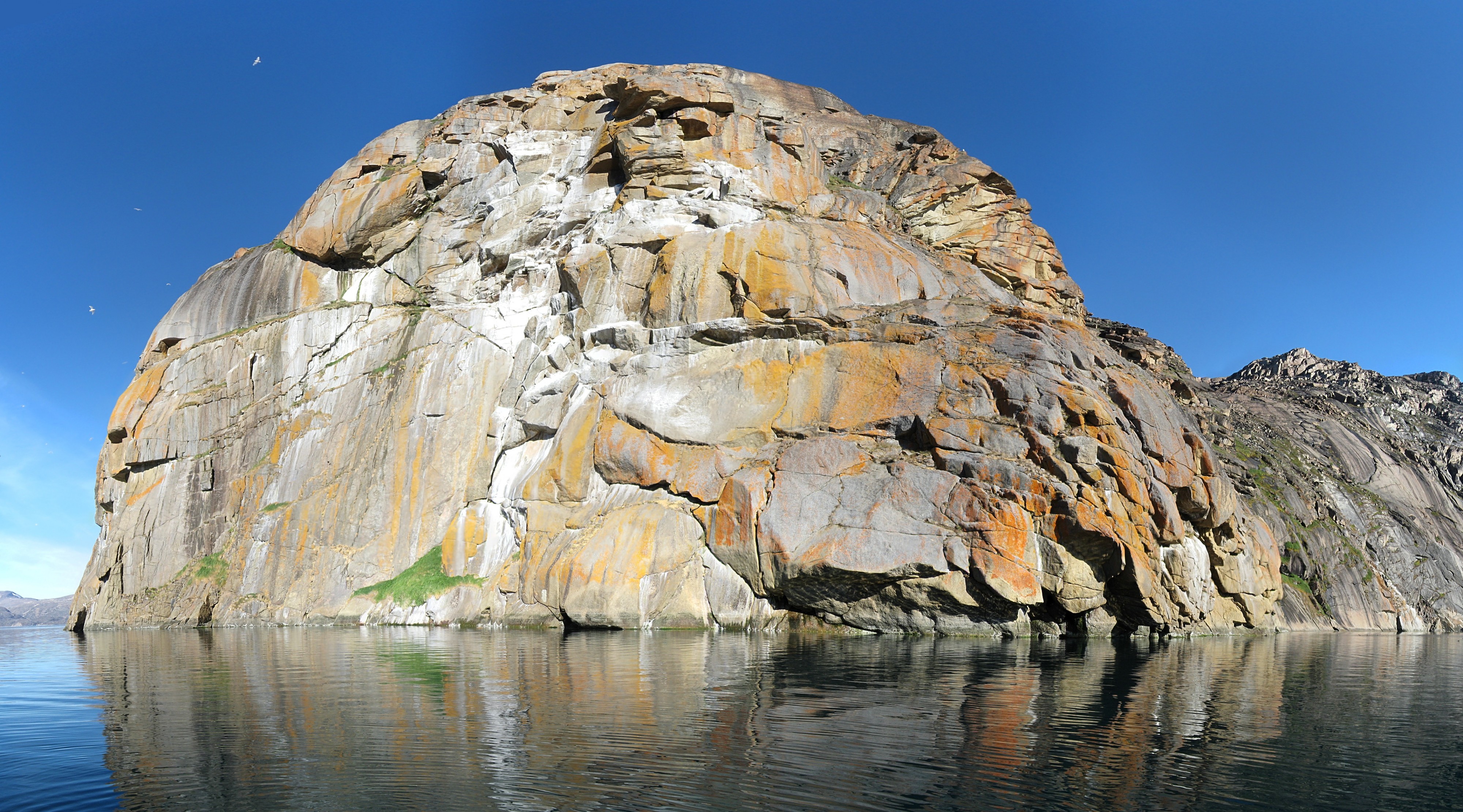
English: Panorama of the island Nunâ east of Upernavik and south of Aappilattoq in Greenland. Photographed south of the island during a sail trip to Upernavik Icefjord. The mountain, which extends 270 m above sea level, is inhabited with Glacous Gulls (Larus hyperboreus). The white areas are bird droppings. The yellow areas are lichen (probably Caloplaca and Xanthoria) adapted to the nutritious environment. The image has been generated using Hugin based on 17 individual photos arranged in three rows. The images were taken with a hand-held camera (Canon DIGITAL IXUS 800 IS) in a small boat that was slowly drifting (not optimal, but it was too deep to anchor). Vignetting has been minimized using a best fit polynomial in Hugin. The output image from Hugin has been rectangularly cropped in GIMP. The colour value curve has been modified slightly to compensate for over-exposure in certain white areas. Hereafter the photo has been Smart Sharpened with a pixel radius of 3.0 and an amount of 30%. the inverted edge detected mask was used in RGB to apply a selective gaussian blur with pixel radius 5.0 of the sky in an attempt to remove noise there. "Missing sky" in the upper left corner has been pasted in by simple colour picking and painting (do not know other methods).
Français : Vue panoramique de l'île de Nûna à l'est de Upernavik et au sud d'Aappilattoq, au Groenland. Image prise au sud de l'île durant un voyage en voilier vers le Fjord d'Upernavik. La montagne, culminant à 270m, est peuplée de goélands. Les zones blanches sont des fientes d'oiseaux, les taches jaunes, du lichen. Image générée en utilisant Hugin, à partir de 17 photos en 3 rangs. Les photos ont été prises d'une barque à la dérive (l'eau était trop profonde pour mouiller l'ancre). Divers traitements (recadrage, courbes, nettetée, supression du vignettage du ciel) ont été appliqués en utilisant les logiciels Hugin et GIMP.
|
| Date | |
| Source | Own work in Hugin and GIMP based on own photographs. |
| Author | Kim Hansen |
| Other versions |
|


|
Camera location |
|
View this and other nearby images on: | (Info) |
|---|
|
|
This image was selected as picture of the day on Wikimedia Commons for . It was captioned as follows: English: Panorama of the island Nunâ in Greenland.
Asturianu: Panorama de la islla Nunâ, en Groenlandia.
Čeština: Ostov Nunâ u pobřeží Grónska
Dansk: Panorama af fuglefjeldet på øen Nunâ øst for Upernavik i Grønland.
Deutsch: Panorama der Insel Nuna vor der Küste Grönlands
English: Panorama of the island Nunâ in Greenland.
Español: Vista de la isla de Nunâ, en Groenlandia.
Français : Vue panoramique de l'île de Nûna à l'est de Upernavik et au sud d'Aappilattoq, au Groenland.
Magyar: Panoráma a grönlandi Nunâ szigetről
Íslenska: Eyjan Nunâ á Grænlandi.
Italiano: Vista dell'isola Nunâ in Groenlandia.
日本語: グリーンランドNunâ島の全景。
ქართული: კუნძული ნუნია, გრენლანდია.
Latina: Despectus in insulam Nunâ, Groenlandiae
Nederlands: Panorama van het eiland Nunâ ten zuiden van het dorp Aappilattoq voor de kust van de Groenlandse gemeente Upernavik
Polski: Pejzaż wyspy Nunâ (Grenlandia).
Português: Panorama da ilha Nunâ na Groenlândia.
Русский: Панорама острова Нунья (Упернавик, Гренландия)
Slovenčina: Panoráma ostrova Nunâ pri pobreží Grónska.
Српски / srpski: Панорама острва Нуна код Гренланда.
Svenska: Ön Nunâ öster om Upernavik vid Grönlands kust.
中文(简体): 格陵兰西部的努纳岛
中文(繁體): 格陵蘭西部的努納島
|
|
This image has been assessed using the Quality image guidelines and is considered a Quality image. |
Licensing:edit
|

Referenceedit
Det Grønne Grønland, Tyge W. Böcher, Ed. by Bent Fredskild and Jens J. Böcher, Rhodos (2000), ISBN 87 7245 845 3, p. 76-77.
GNU Free Documentation License
| EXIF data: | |
| File name | nuna__island_upernavik_district_2007-08-09_3.jpg |
|---|---|
| Size, Mbytes | 4.7485068359375 |
| Mime type | image/jpeg |
While the copyright and licensing information supplied for each photo is believed to be accurate, Free-Photos.biz does not provide any warranty regarding the copyright status or correctness of licensing terms. If you decide to reuse the images from Free-Photos.biz, you should verify the copyright status of each image just as you would when obtaining images from other sources.
The use of depictions of living or deceased persons may be restricted in some jurisdictions by laws regarding personality rights. Such images are exhibited at Free-Photos.biz as works of art that serve higher artistic interests.
PRIVACY POLICY
By registering your account and/or by subscribing to new and newly rated photographs you agree we may send you the links to photos and we may occasionally share other information with you.
We do NOT disclose your personal data.
