
Please login in order to download photos in full size
If you are not registered, please register for free: www.Free-Photos.biz/register
Please note to download premium images you also need to join as a free member..
You can also save the photos without the registration - but only in small and average sizes, and some of them will have the site's watermark. Please simply click your right mouse button and save the image.
Please login in order to like photos
If you are not registered, please register for free:
Sorry, non-members can download up to 100 full-size photos per month.
It looks like you have used up your limit.
Free members can download an unlimited number of full-size photos - including the premium free photos.
Join as a member today for FREE! - and download the images without limitations:
www.Free-Photos.biz/membership.php
You can also save the images without the membership - but only in small and average sizes, and some of them may have the site's watermark. Please simply click your right mouse button and save the image.
|
Download top free photographs!
This photo was viewed 9 times and was downloaded in full size 9 times.
This photo was liked 0 times


Source page: | http://commons.wikimedia.org/wiki/File:Kamchatka_peninsula_topo.jpg |
|---|
| Warning | The original file has a large number of pixels and when opened at full resolution, may either not load properly or cause your browser to freeze. These problems can be avoided by use of the ZoomViewer.
|
|---|
| Description |
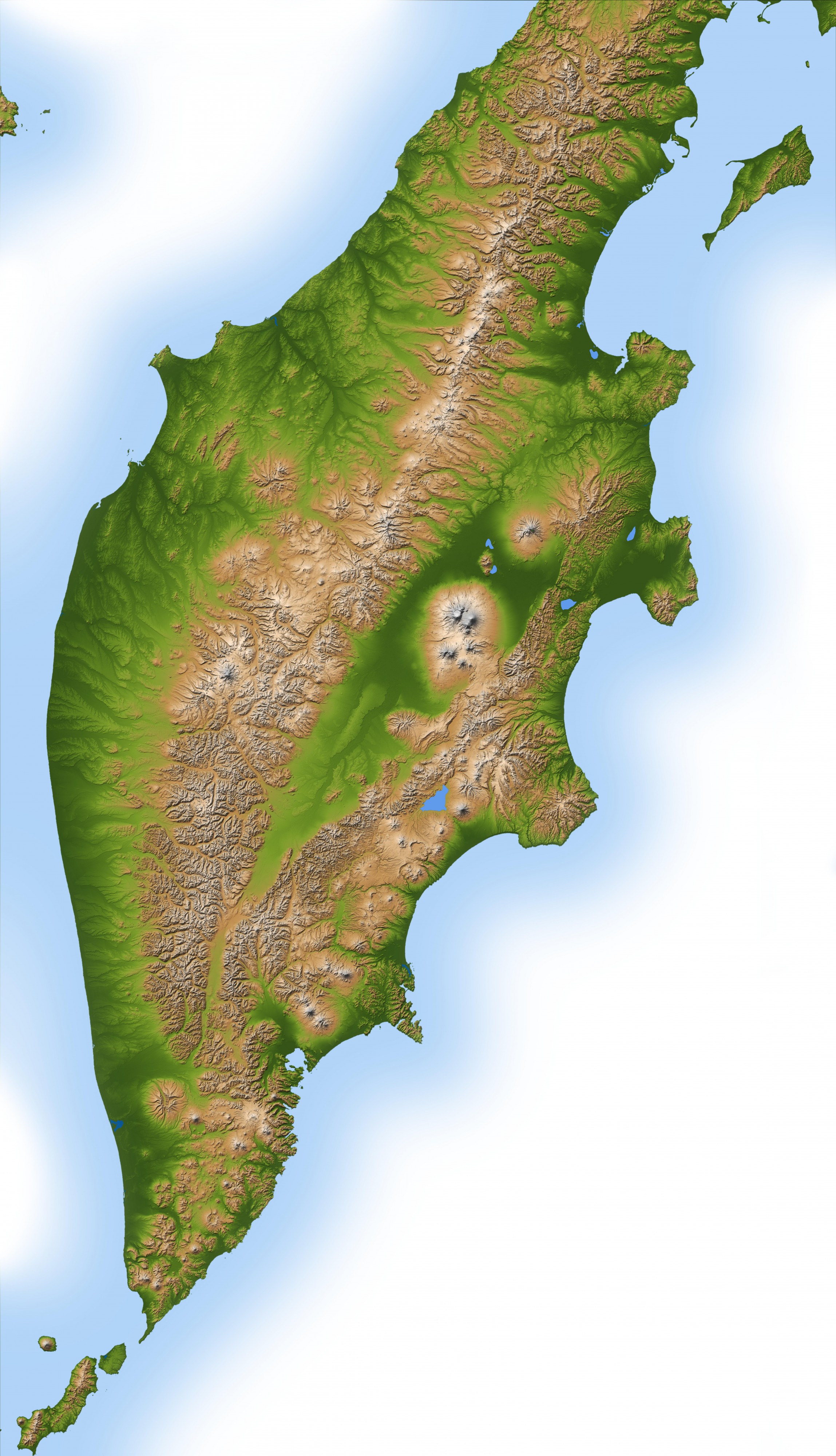
Topography of Kamchatka Peninsula. Russia's Kamchatka Peninsula, lying between the Sea of Okhotsk to the west and the Bering Sea and Pacific Ocean to the east, is one of the most active volcanic regions along the Pacific Ring of Fire. It covers an area about the size of Colorado but contains more than 100 volcanoes stretching across the 1000-kilometer-long (620-mile-long) land mass. A dozen or more of these have active vents, with the youngest located along the eastern half of the peninsula. This color-coded shaded relief image, generated with data from the Shuttle Radar Topography Mission (SRTM), shows Kamchatka's volcanic nature to dramatic effect. Kliuchevskoi, one of the most active and renowned volcanoes in the world, dominates the main cluster of volcanoes called the Kliuchi group, visible as a circular feature in the center-right of the image. The two other main volcanic ranges lie along northeast-southwest lines, with the older, less active range occupying the center and western half of Kamchatka. The younger, more active belt begins at the southernmost point of the peninsula and continues upward along the Pacific coastline. Two visualization methods were combined to produce this image: shading and color coding of topographic height. The shade image was derived by computing topographic slope in the north-south direction, so northern slopes appear bright and southern slopes appear dark. Color coding is directly related to topographic height, with green at the lower elevations, rising through yellow and brown to white at the highest elevations. The Shuttle Radar Topography Mission flew aboard the Space Shuttle Endeavour, launched on February 11, 2000. The mission used the same radar instrument that comprised the Spaceborne Imaging Radar-C/X-Band Synthetic Aperture Radar that flew twice on the Space Shuttle Endeavour in 1994. The Shuttle Radar Topography Mission was designed to collect three-dimensional measurements of the Earth's surface. To collect the 3-D data, engineers added a 60-meter (200-foot)-long mast, installed additional C-band and X-band antennas, and improved tracking and navigation devices. The mission is a cooperative project between NASA, the National Imagery and Mapping Agency of the U.S. Department of Defense, and the German and Italian space agencies. It is managed by NASA's Jet Propulsion Laboratory, Pasadena, Calif., for NASA's Earth Science Enterprise, Washington, D.C. |
|||||
| Date | ||||||
| Source | https://photojournal.jpl.nasa.gov/catalog/PIA03374 | |||||
| Author | NASA/JPL/NIMA | |||||
| Permission (Reusing this file) |
|
|||||
| Other versions |
Cropped version : File:Kliuchevskoi volcanic group topo.jpg |
This image or video was catalogued by Jet Propulsion Laboratory of the United States National Aeronautics and Space Administration (NASA) under Photo ID: PIA03374. This tag does not indicate the copyright status of the attached work. A normal copyright tag is still required. See Commons:Licensing for more information. |
| EXIF data: | |
| File name | kamchatka_peninsula_topo.jpg |
|---|---|
| Size, Mbytes | 9.4000380859375 |
| Mime type | image/jpeg |
While the copyright and licensing information supplied for each photo is believed to be accurate, Free-Photos.biz does not provide any warranty regarding the copyright status or correctness of licensing terms. If you decide to reuse the images from Free-Photos.biz, you should verify the copyright status of each image just as you would when obtaining images from other sources.
The use of depictions of living or deceased persons may be restricted in some jurisdictions by laws regarding personality rights. Such images are exhibited at Free-Photos.biz as works of art that serve higher artistic interests.
PRIVACY POLICY
By registering your account and/or by subscribing to new and newly rated photographs you agree we may send you the links to photos and we may occasionally share other information with you.
We do NOT disclose your personal data.
