

Please login in order to download photos in full size
If you are not registered, please register for free: www.Free-Photos.biz/register
Please note to download premium images you also need to join as a free member..
You can also save the photos without the registration - but only in small and average sizes, and some of them will have the site's watermark. Please simply click your right mouse button and save the image.
Please login in order to like photos
If you are not registered, please register for free:
Sorry, non-members can download up to 100 full-size photos per month.
It looks like you have used up your limit.
Free members can download an unlimited number of full-size photos - including the premium free photos.
Join as a member today for FREE! - and download the images without limitations:
www.Free-Photos.biz/membership.php
You can also save the images without the membership - but only in small and average sizes, and some of them may have the site's watermark. Please simply click your right mouse button and save the image.
|
Download top free photographs!
This photo was viewed 29 times and was downloaded in full size 4 times.
This photo was liked 0 times


If you are a member, please login in order to see the source link of the above image.
|
|
This is a featured picture on Wikimedia Commons (Featured pictures) and is considered one of the finest images. This file was a candidate in Picture of the Year 2006. This is a featured picture on the German language Wikipedia (Exzellente Bilder) and is considered one of the finest images. This is a featured picture on the English language Wikipedia (Featured pictures) and is considered one of the finest images. This is a featured picture on the Spanish language Wikipedia (Recursos destacados) and is considered one of the finest images. This is a featured picture on the Romanian language Wikipedia (Imagini de calitate) and is considered one of the finest images. This is a featured picture on the Turkish language Wikipedia (Seçkin resimler) and is considered one of the finest images. If you have an image of similar quality that can be published under a suitable copyright license, be sure to upload it, tag it, and nominate it. |
|

| Description |
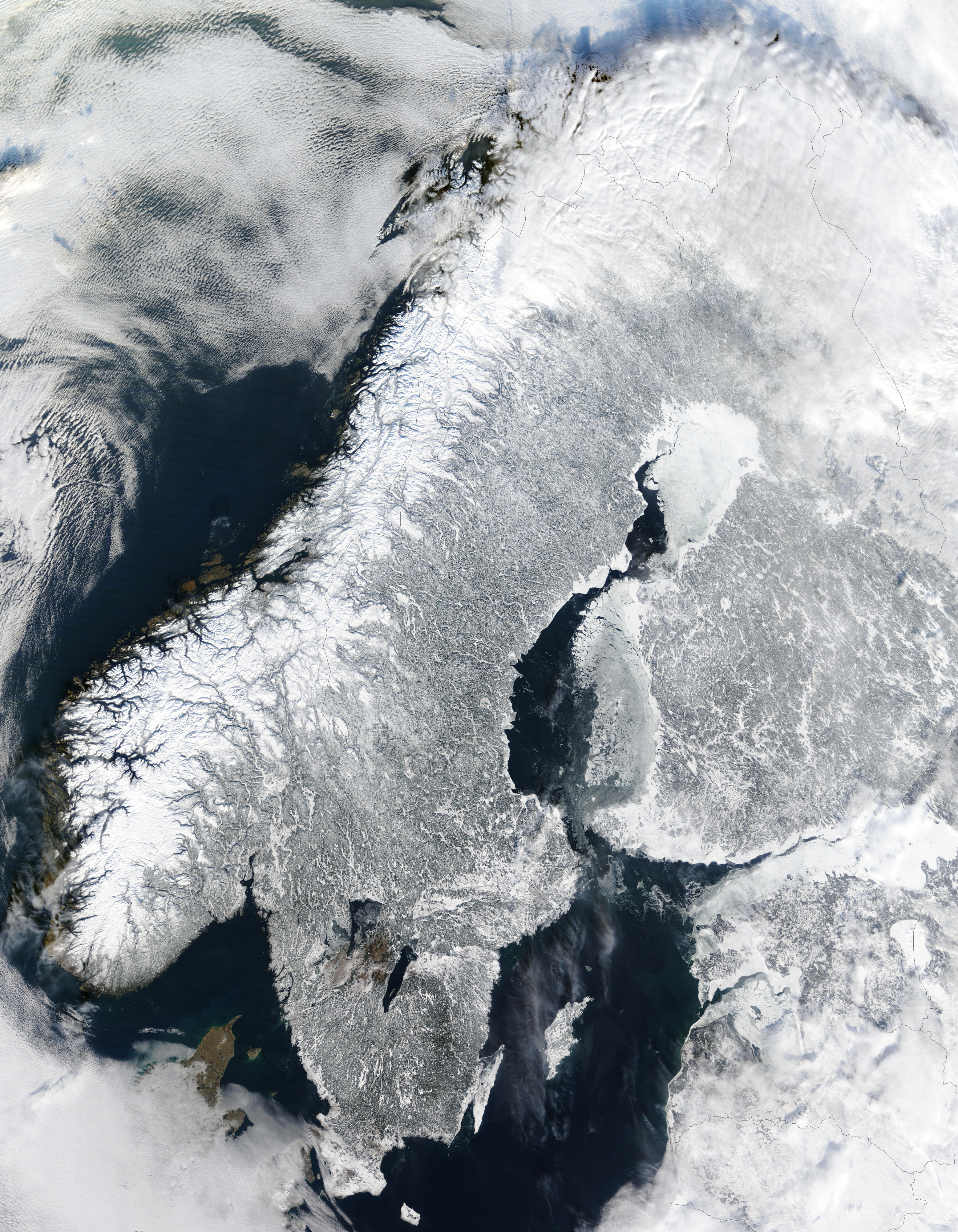
English: Scandinavia from space in winter.
The Moderate Resolution Imaging Spectroradiometer (MODIS) instrument aboard NASA’s Terra satellite captured the above image of the Scandinavian Peninsula on February 19, 2003. Español: Escandinavia en invierno, imagen de la NASA
Français : Scandinavie en hiver depuis l'espace. Image prise par l'instrument MODIS à bord du satellite Terra de la NASA.
Avec ses paysages sculptés par les glaciers du quaternaire, la Scandinavie en hiver est aussi pittoresque que froide. A l'ouest sont visibles les étroits bras de mer appelés fjords, qui ponctuent la côte norvégienne. Ces fjords très profonds (plus de 600 m et jusque 1308m dans le Sognefjord) ont étés creusés par de lourds glaciers au cours des âges glaciaires. Ces glaciers descendus de la montagne ont creusé leurs vallées bien en dessous du niveau de la mer. A la fin de la glaciation, c'est donc la mer qui a envahis ces profondes vallées. Nederlands: Satellietopname van Noorwegen, Zweden en Finland in de winter
Român?: Peninsula Sandinav? în timpul iernii — vedere din satelit (19 februarie 2003).
???????: ????????????? ?????????? ????? (19 ??????? 2003)
Svenska: Satellitbild över Skandinavien. I Norge finns det fjordar, i Sverige sjöar och i Finland också. Hela halvön är täckt av snö på vintern. Även om det är kallt om vintern nu, så var det ännu kallare på istiden.
|
| Date | 19 February 2003 |
| Source | MODIS Land Rapid Response Team |
| Author | Jacques Descloitres, MODIS Land Rapid Response Team at NASA GSFC |
| Permission (Reusing this file) |
Quote of https://rapidfire.sci.gsfc.nasa.gov/faq/ - All the images that appear on our site are in the public domain and can be freely used and reproduced for any purpose. Please credit the MODIS Rapid Response Project appropriately: "Image courtesy of MODIS Rapid Response Project at NASA/GSFC". |
| This file is in the public domain because it was created by NASA. NASA copyright policy states that "NASA material is not protected by copyright unless noted". (See Template:PD-USGov, NASA copyright policy page or JPL Image Use Policy.)
|
|
|
|
Warnings:
|
|
This image was selected as a picture of the day for 12 January 2005. It was captioned as follows: English: Scandinavia from space in winter.
?esky: Zimní Skandinávie p?i pohledu z vesmíru
Deutsch: Winterliches Skandinavien aus dem Weltraum gesehen
English: Scandinavia from space in winter.
Esperanto: Skandinavio de spaco vintre.
Español: La Península Escandinava en invierno vista desde el espacio
Suomi: Kuva talvisesta Fenno-Skandiasta ja Baltiasta avaruudesta kuvattuna
Français : Vue depuis orbite terrestre de la péninsule scandinave en hiver.
Italiano: Vista della Scandinavia innevata dallo spazio.
???: ????????????
???: ??????? ????.
|
Public Domain
| EXIF data: | |
| File name | scandinavia.tmo2003050.jpg |
|---|---|
| Size, Mbytes | 7.5938603515625 |
| Mime type | image/jpeg |
While the copyright and licensing information supplied for each photo is believed to be accurate, Free-Photos.biz does not provide any warranty regarding the copyright status or correctness of licensing terms. If you decide to reuse the images from Free-Photos.biz, you should verify the copyright status of each image just as you would when obtaining images from other sources.
The use of depictions of living or deceased persons may be restricted in some jurisdictions by laws regarding personality rights. Such images are exhibited at Free-Photos.biz as works of art that serve higher artistic interests.
PRIVACY POLICY
By registering your account and/or by subscribing to new and newly rated photographs you agree we may send you the links to photos and we may occasionally share other information with you.
We do NOT disclose your personal data.
