

Please login in order to download photos in full size
If you are not registered, please register for free: www.Free-Photos.biz/register
Please note to download premium images you also need to join as a free member..
You can also save the photos without the registration - but only in small and average sizes, and some of them will have the site's watermark. Please simply click your right mouse button and save the image.
Please login in order to like photos
If you are not registered, please register for free:
Sorry, non-members can download up to 1100 full-size photos per month.
It looks like you have used up your limit.
Free members can download an unlimited number of full-size photos - including the premium free photos.
Join as a member today for FREE! - and download the images without limitations:
www.Free-Photos.biz/membership.php
You can also save the images without the membership - but only in small and average sizes, and some of them may have the site's watermark. Please simply click your right mouse button and save the image.
|
This is a premium free photo
This photo was viewed 2 times and was downloaded in full size 1 times.
This photo was liked 0 times


Source page: |
http://commons.wikimedia.org/wiki/File:Aerial_view_of_Pearl_Harbor_on_3_May_1940.jpg |
|---|
Summaryedit
| Description |
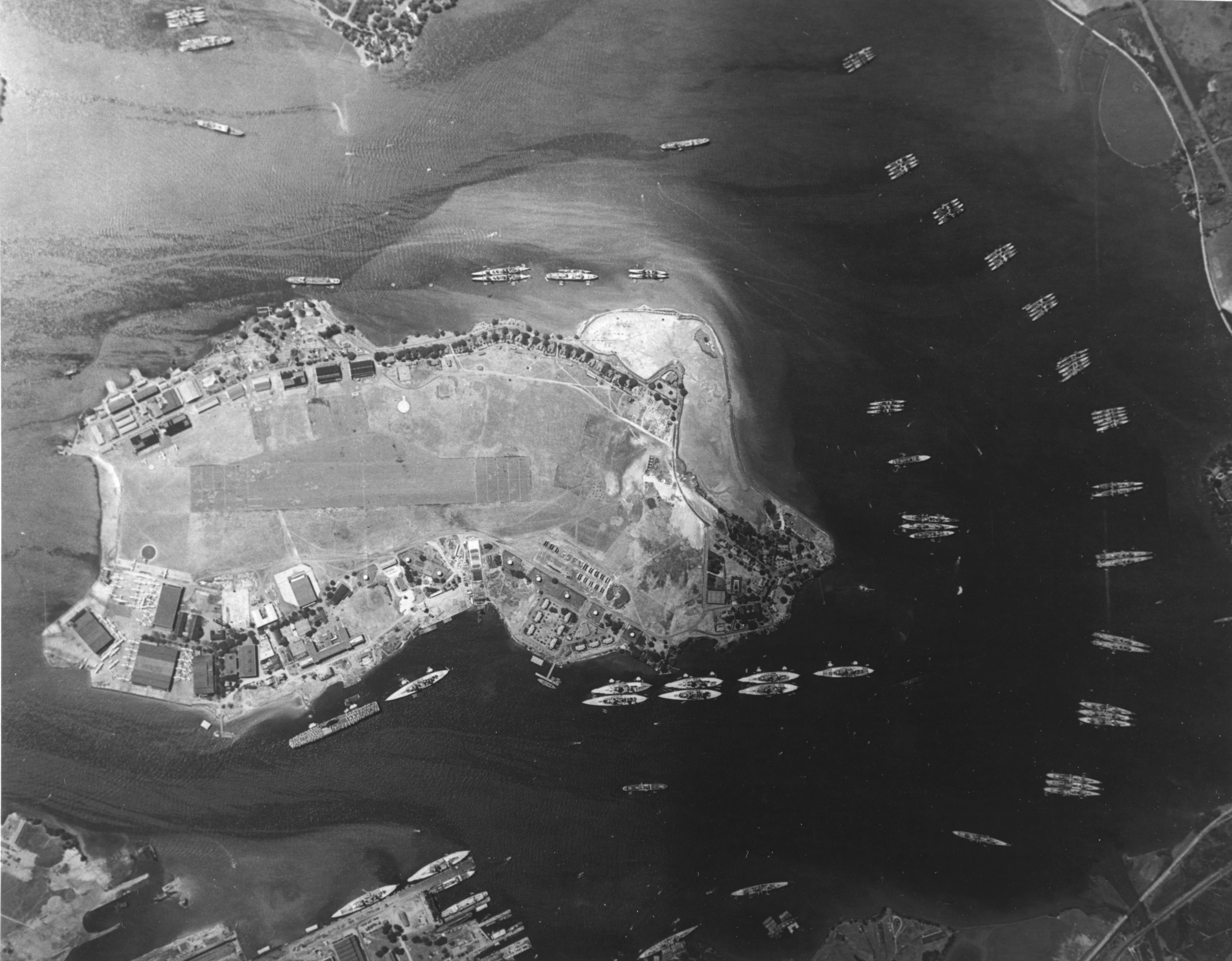
Vertical aerial photograph of Pearl Harbor, Hawaii (USA), from 5,250 m (17,200 ft) altitude, looking directly down on East Loch and on the Fleet Air Base on Ford Island. Taken on 3 May 1940, after the conclusion of Fleet Problem XXI, and just prior to the 7 May receipt of word that the Fleet was to be retained in Hawaiian waters. There are eight battleships and the carrier USS Yorktown (CV-5) tied up along the island's southeastern side (toward the top), with two more battleships alongside 1010 dock at top right center. Two light cruisers and two destroyers are among the ships moored along Ford Island's northwestern side. Seventeen other cruisers and over thirty destroyers are also visible, mainly in East Loch. At the seaplane base, at the southern (top right) tip of Ford Island, are at least 38 Consolidated PBY patrol planes. |
| Date | |
| Source | Official U.S. Navy photo 80-G-411117 from the U.S. Navy Naval History and Heritage Command |
| Author | U.S. Navy |
Licensingedit
| This file is a work of a sailor or employee of the U.S. Navy, taken or made as part of that person's official duties. As a work of the U.S. federal government, the image is in the public domain in the United States. |
 |
|
|
|
||
| EXIF data: | |
| File name | aerial_view_of_pearl_harbor_on_3_may_1940.jpg |
|---|---|
| Size, Mbytes | 9.022578125 |
| Mime type | image/jpeg |
While the copyright and licensing information supplied for each photo is believed to be accurate, Free-Photos.biz does not provide any warranty regarding the copyright status or correctness of licensing terms. If you decide to reuse the images from Free-Photos.biz, you should verify the copyright status of each image just as you would when obtaining images from other sources.
The use of depictions of living or deceased persons may be restricted in some jurisdictions by laws regarding personality rights. Such images are exhibited at Free-Photos.biz as works of art that serve higher artistic interests.
PRIVACY POLICY
By registering your account and/or by subscribing to new and newly rated photographs you agree we may send you the links to photos and we may occasionally share other information with you.
We do NOT disclose your personal data.
