

Please login in order to download photos in full size
If you are not registered, please register for free: www.Free-Photos.biz/register
Please note to download premium images you also need to join as a free member..
You can also save the photos without the registration - but only in small and average sizes, and some of them will have the site's watermark. Please simply click your right mouse button and save the image.
Please login in order to like photos
If you are not registered, please register for free:
Sorry, non-members can download up to 1100 full-size photos per month.
It looks like you have used up your limit.
Free members can download an unlimited number of full-size photos - including the premium free photos.
Join as a member today for FREE! - and download the images without limitations:
www.Free-Photos.biz/membership.php
You can also save the images without the membership - but only in small and average sizes, and some of them may have the site's watermark. Please simply click your right mouse button and save the image.
|
This is a premium free photo
This photo was viewed 1 times and was downloaded in full size 1 times.
This photo was liked 0 times


If you are a member, please login in order to see the source link of the above image.
Summaryedit
| Artist |
|
|||||||||||||||||||
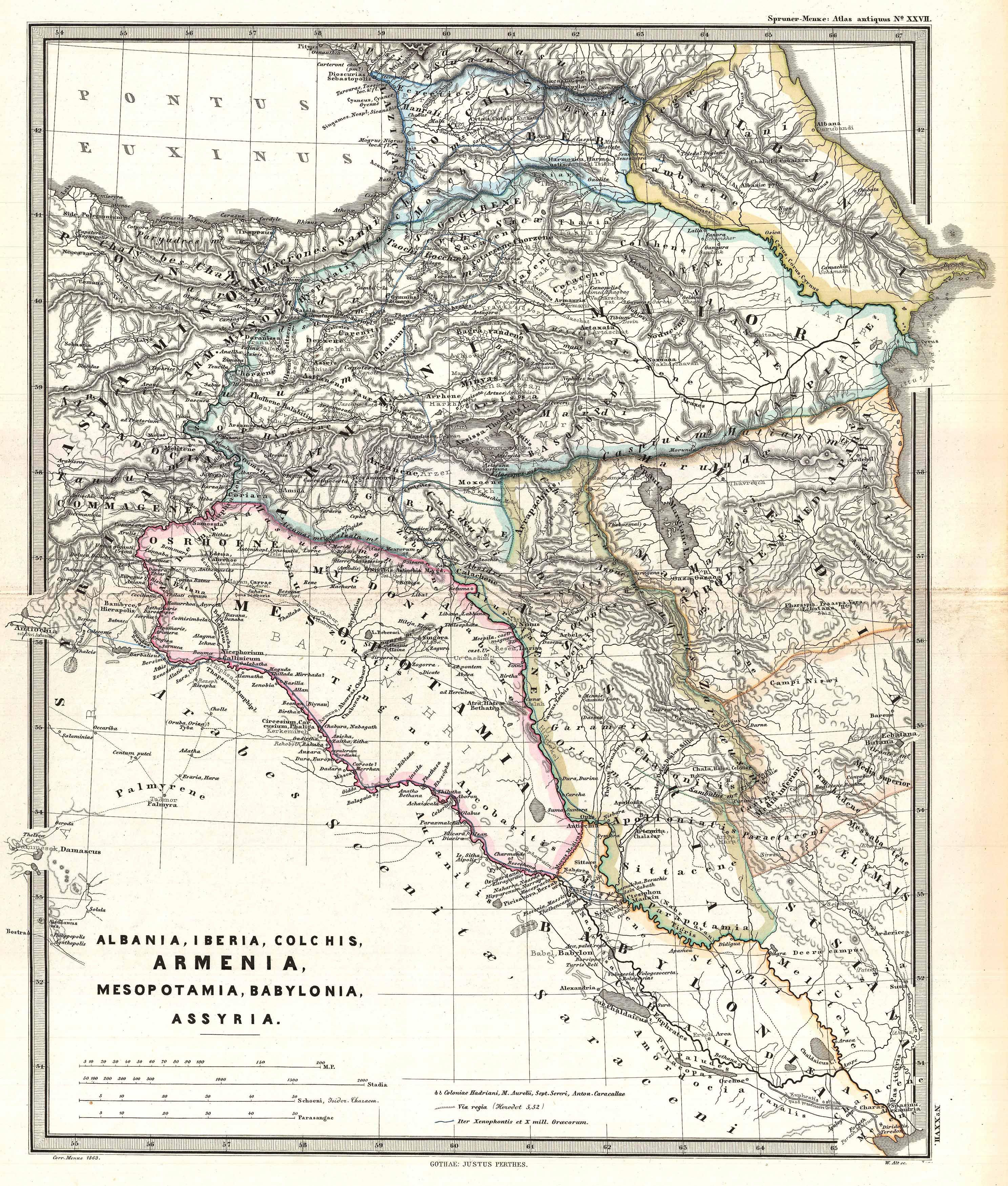
| Title | Albania, Iberia, Colchis, Armenia, Mesopotamia, Babylonia, Assyria. | |||||||||||||||||||
| Description |
English: A particularly interesting map, this is Karl von Spruner’s 1865 rendering of the Caucasus and Mesopotamia in antiquity. Centered on Lake Van (modern day eastern Turkey), this map covers the Caucasus region between the Black Sea and the Caspian Sea, then southwards to the Fertile Crescent as far as the Euphrates River, Babylonia, and the head of the Persian Gulf. These regions include the modern day countries of Iraq, Armenia, Georgia, Azerbaijan, and adjacent parts of Syria, Turkey, Iran, and the North Caucasus. Like most of Spruner’s work this example overlays ancient political geographies on relatively contemporary physical geographies, thus identifying the sites of forgotten towns and villages, the movements of armies, and the disposition of lands in the region. This particular example includes ancient names for many notable regions and historical sites. As a whole the map labels important cities, rivers, mountain ranges and other minor topographical detail. Territories and countries outlined in color. The whole is rendered in finely engraved detail exhibiting the fine craftsmanship for which the Perthes firm is known.
Deutsch: Antikes Vorderasien. Die Karte reicht im Westen bis Bosra, Damaskus, Antiochien und die Mündung des Iris (Yeşilırmak) ins Schwarze Meer, im Norden bis Pityus (Pizunda) an der Schwarzmeerküste und zum dagestanischen Fluß Sulak, im Osten bis Abşeron, Ekbatana und Susa und im Süden bis zur Mündung von Euphrat und Tigris.
|
|||||||||||||||||||
| Date | (undated) | |||||||||||||||||||
| Dimensions | Height: 16 in (40.6 cm). Width: 13 in (33 cm). | |||||||||||||||||||
| Accession number | Geographicus code: CaucusesIraq-spruner-1865 | |||||||||||||||||||
| Source/Photographer |
Spruner, Karl von, Spruner-Menke Atlas Antiquus,, (Gotha: Justus Perthes), 1865.
|
|||||||||||||||||||
| Permission (Reusing this file) |
|
|||||||||||||||||||
Licensingedit
This photographic reproduction is therefore also considered to be in the public domain. In other jurisdictions, re-use of this content may be restricted; see Reuse of PD-Art photographs for details. |
||||
Public Domain
| EXIF data: | |
| File name | 1965_spruner_map_of_the_caucasus_and_iraq_in_antiquity_-_geographicus_-_caucusesiraq-spruner-1865.jpg |
|---|---|
| Size, Mbytes | 2.50451171875 |
| Mime type | image/jpeg |
While the copyright and licensing information supplied for each photo is believed to be accurate, Free-Photos.biz does not provide any warranty regarding the copyright status or correctness of licensing terms. If you decide to reuse the images from Free-Photos.biz, you should verify the copyright status of each image just as you would when obtaining images from other sources.
The use of depictions of living or deceased persons may be restricted in some jurisdictions by laws regarding personality rights. Such images are exhibited at Free-Photos.biz as works of art that serve higher artistic interests.
PRIVACY POLICY
By registering your account and/or by subscribing to new and newly rated photographs you agree we may send you the links to photos and we may occasionally share other information with you.
We do NOT disclose your personal data.
