

Please login in order to download photos in full size
If you are not registered, please register for free: www.Free-Photos.biz/register
Please note to download premium images you also need to join as a free member..
You can also save the photos without the registration - but only in small and average sizes, and some of them will have the site's watermark. Please simply click your right mouse button and save the image.
Please login in order to like photos
If you are not registered, please register for free:
Sorry, non-members can download up to 1100 full-size photos per month.
It looks like you have used up your limit.
Free members can download an unlimited number of full-size photos - including the premium free photos.
Join as a member today for FREE! - and download the images without limitations:
www.Free-Photos.biz/membership.php
You can also save the images without the membership - but only in small and average sizes, and some of them may have the site's watermark. Please simply click your right mouse button and save the image.
|
This is a premium free photo
This photo was viewed 4 times and was downloaded in full size 1 times.
This photo was liked 0 times


Source page: |
http://commons.wikimedia.org/wiki/File:San_Francisquito_Reservoir_on_topo_v2.jpg |
|---|
Summaryedit
| Description |
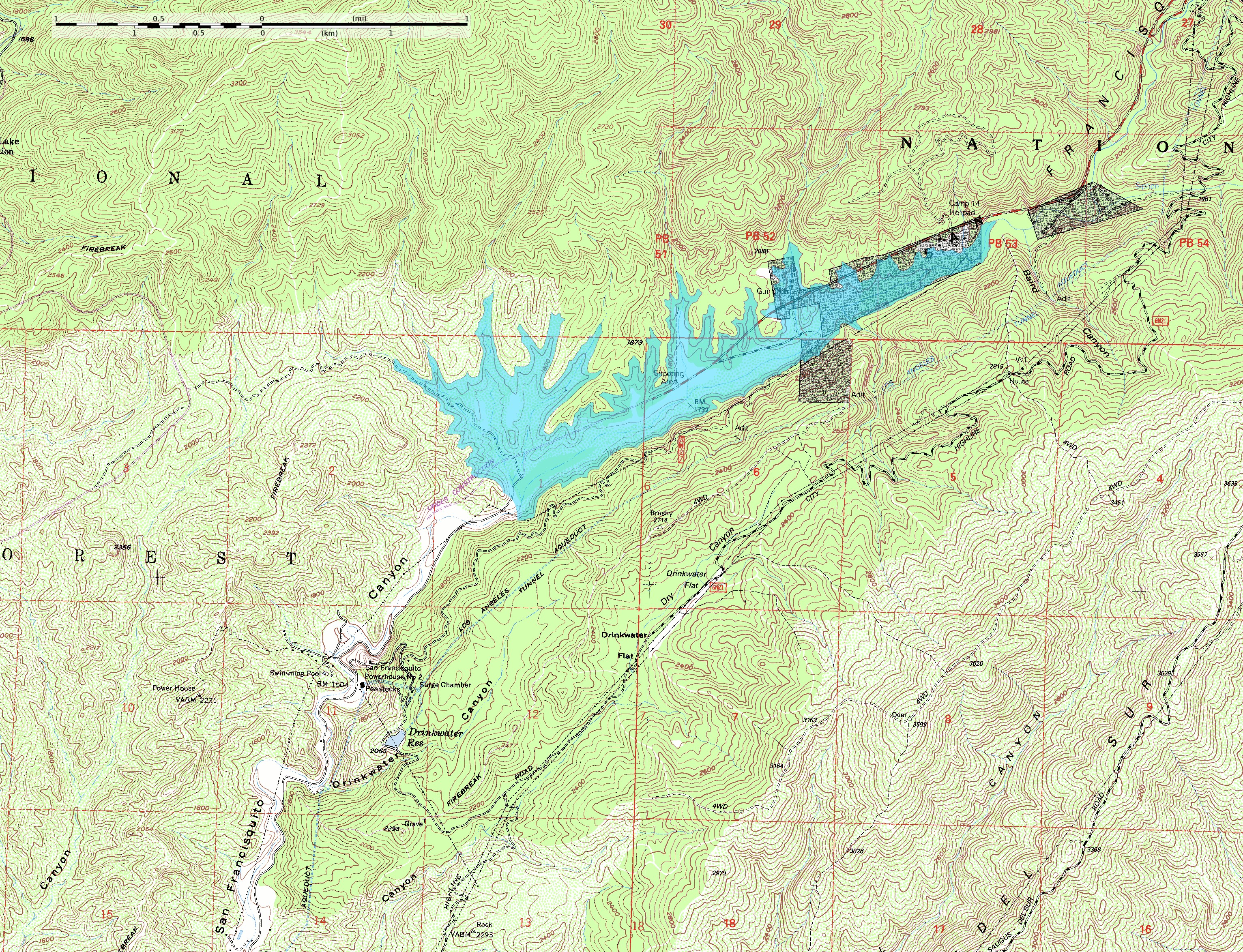
English: This map shows the approximate extent of the former San Francisquito Reservoir. The reservoir was impounded by the St. Francis Dam which failed in 1928. According to this depiction the reservoir was approximately 2.8 miles (4.5 km) long. In addition to the reservoir this map also shows the location of part of the Los Angeles Aqueduct from which it was filled; it was built as a storage stucture for the aqueduct. Also visible on the map at full size is the location of Powerhouse #2 which figures in the story of the flood created by the failure of the dam. The dark blocks indicate private inholdings in the national forest.
The reservoir extent was determined by tracing at or just below the 1840-foot elevation contour; the pool elevation was about 1835 feet when full and when the dam collapsed. The topo map includes sections of the Warm Springs Mountain 7.5" quadrangle (o34118e5) and the Green Valley quadrangle (o34118e4) from the USGS obtained as DRG files. Note: The location and orientation of the dam (at the southwest extent of the reservoir) is approximate. Additionally, the elevation data in this map is from after the breach of the dam, which caused significant erosion of the hillside at the southeast abuttment; the dam was probably a little smaller than this reconstruction depicts. |
| Date | |
| Source | Own work |
| Author | Kbh3rd |
| Other versions |

| Camera location | View this and other nearby images on: OpenStreetMap - Google Earth |
|---|
Licensingedit
|
I, the copyright holder of this work, hereby publish it under the following licenses:
You may select the license of your choice.
|

| EXIF data: | |
| File name | san_francisquito_reservoir_on_topo_v2.jpg |
|---|---|
| Size, Mbytes | 4.5720634765625 |
| Mime type | image/jpeg |
While the copyright and licensing information supplied for each photo is believed to be accurate, Free-Photos.biz does not provide any warranty regarding the copyright status or correctness of licensing terms. If you decide to reuse the images from Free-Photos.biz, you should verify the copyright status of each image just as you would when obtaining images from other sources.
The use of depictions of living or deceased persons may be restricted in some jurisdictions by laws regarding personality rights. Such images are exhibited at Free-Photos.biz as works of art that serve higher artistic interests.
PRIVACY POLICY
By registering your account and/or by subscribing to new and newly rated photographs you agree we may send you the links to photos and we may occasionally share other information with you.
We do NOT disclose your personal data.
