

Please login in order to download photos in full size
If you are not registered, please register for free: www.Free-Photos.biz/register
Please note to download premium images you also need to join as a free member..
You can also save the photos without the registration - but only in small and average sizes, and some of them will have the site's watermark. Please simply click your right mouse button and save the image.
Please login in order to like photos
If you are not registered, please register for free:
Sorry, non-members can download up to 1100 full-size photos per month.
It looks like you have used up your limit.
Free members can download an unlimited number of full-size photos - including the premium free photos.
Join as a member today for FREE! - and download the images without limitations:
www.Free-Photos.biz/membership.php
You can also save the images without the membership - but only in small and average sizes, and some of them may have the site's watermark. Please simply click your right mouse button and save the image.
|
This is a premium free photo
This photo was viewed 1 times and was downloaded in full size 0 times.
This photo was liked 0 times


If you are a member, please login in order to see the source link of the above image.
| Artist | https://www.geographicus.com/mm5/cartographers/dufour.txt | |||||
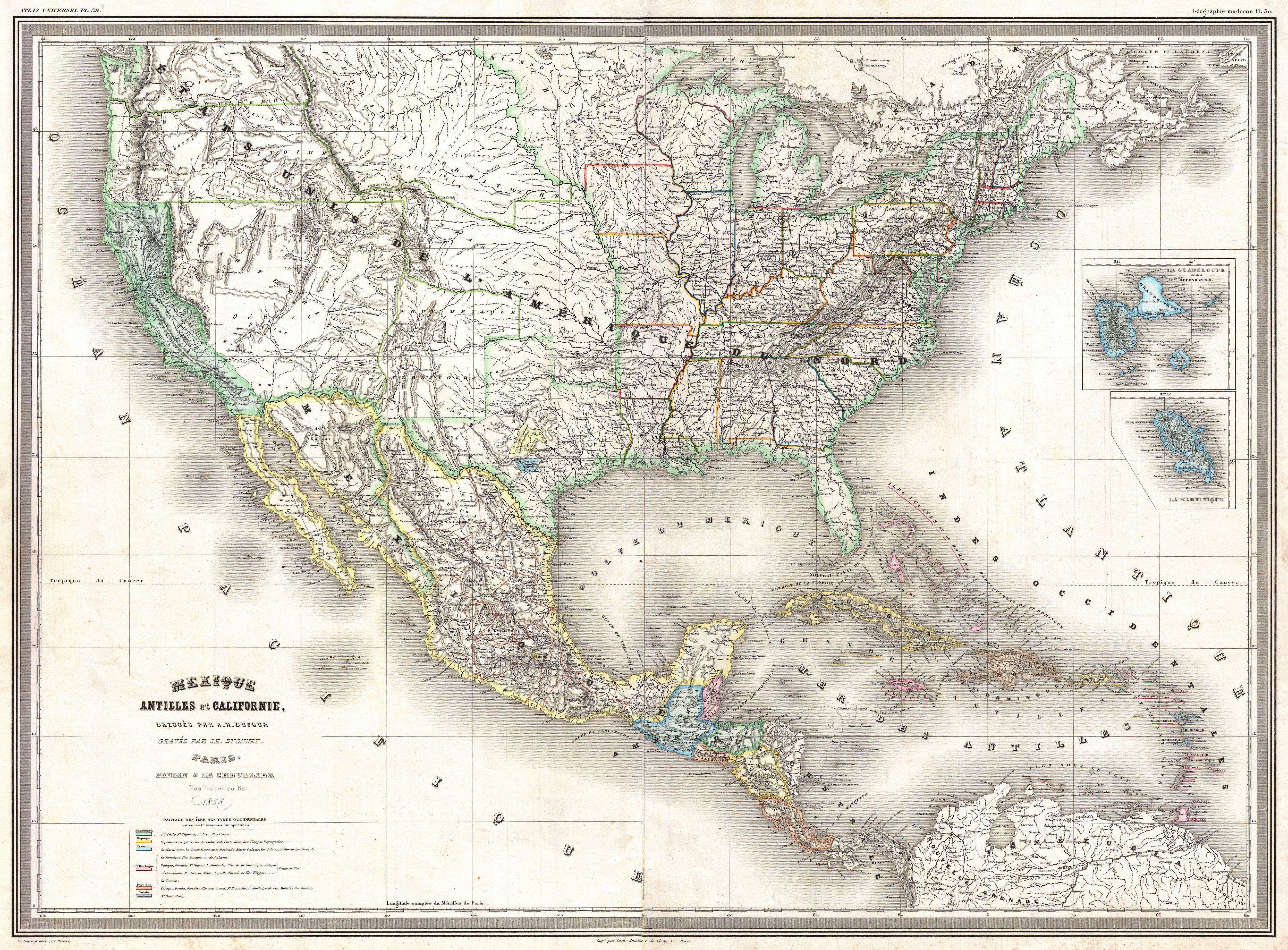
| Title | Mexique Antilles et Californie | |||||
| Description |
English: A finely detailed large format 1858 map of the United States on Mercator's projection by the French cartographer A. H. Dufour. Convers the entirety of the United States during the brief period following the Gold Rush but before the outbreak of the American Civil War. The European influence of this map can be seen in the French (around San Antonio) and German (near Austin) colonies noted in Texas. Castroville appears as the major town in the Col. Française, which extends west to the Frio River. The Col. Allemande shows the Adelsverein's area between the Colorado and Llano Rivers with Fredericksburg as its primary town. An expansive West Texas presents a very wide Panhandle and Trans-Pecos region. Nebraska extends to the Canadian border. Though this map postdates the Gadsden Purchase, the border is shown in the pre-Gadsden configuration. The eastern border of California is curiously defined by the Sierra Nevada range rather than by straight boundary lines. Interestingly, though clearly a map of the United States, California seems to be the focus of this map and is highlighted appropriately in both the map’s title and with vivid full color. Most likely this is a reflection of European interest in the Gold Rush. The two inserts are of the French Caribbean island possessions, the remnants of France's once extensive New World empire. Engraved by Charles Dyonnet for A. H. Dufour’s Atlas Universal .
|
|||||
| Date | 1858 (dated) | |||||
| Dimensions | Height: 22.5 in (57.2 cm). Width: 30 in (76.2 cm). | |||||
| Accession number | Geographicus code: UnitedStates-dufour-1858 | |||||
| Source/Photographer |
Dufour, A. H., Atlas Universel, (Paris) 1858.
|
|||||
| Permission (Reusing this file) |
|
|||||
Public Domain
| EXIF data: | |
| File name | 1858_dufour_map_of_the_united_states_-_geographicus_-_unitedstates-dufour-1858.jpg |
|---|---|
| Size, Mbytes | 5.2290654296875 |
| Mime type | image/jpeg |
While the copyright and licensing information supplied for each photo is believed to be accurate, Free-Photos.biz does not provide any warranty regarding the copyright status or correctness of licensing terms. If you decide to reuse the images from Free-Photos.biz, you should verify the copyright status of each image just as you would when obtaining images from other sources.
The use of depictions of living or deceased persons may be restricted in some jurisdictions by laws regarding personality rights. Such images are exhibited at Free-Photos.biz as works of art that serve higher artistic interests.
PRIVACY POLICY
By registering your account and/or by subscribing to new and newly rated photographs you agree we may send you the links to photos and we may occasionally share other information with you.
We do NOT disclose your personal data.
