

Please login in order to download photos in full size
If you are not registered, please register for free: www.Free-Photos.biz/register
Please note to download premium images you also need to join as a free member..
You can also save the photos without the registration - but only in small and average sizes, and some of them will have the site's watermark. Please simply click your right mouse button and save the image.
Please login in order to like photos
If you are not registered, please register for free:
Sorry, non-members can download up to 100 full-size photos per month.
It looks like you have used up your limit.
Free members can download an unlimited number of full-size photos - including the premium free photos.
Join as a member today for FREE! - and download the images without limitations:
www.Free-Photos.biz/membership.php
You can also save the images without the membership - but only in small and average sizes, and some of them may have the site's watermark. Please simply click your right mouse button and save the image.
|
Download top free photographs!
This photo was viewed 21 times and was downloaded in full size 7 times.
This photo was liked 0 times


Source page: | http://commons.wikimedia.org/wiki/File:First_Picture_of_Mars_-_GPN-2000-001699.jpg |
|---|
| Description |
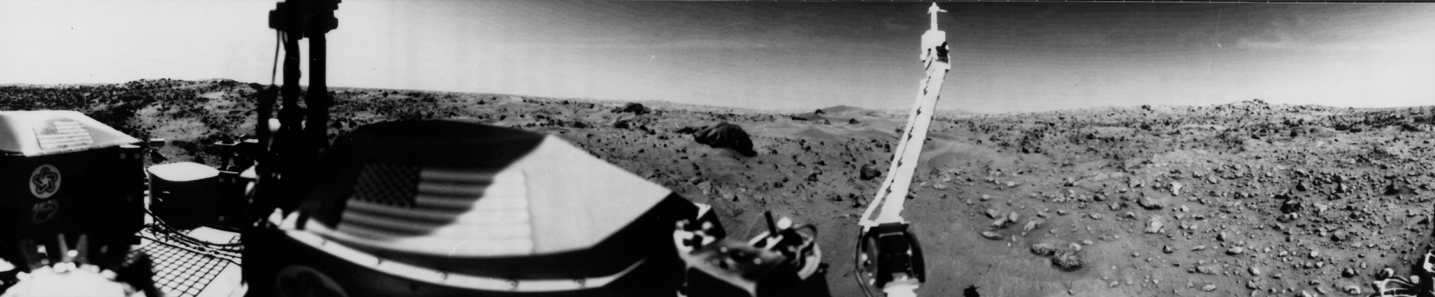
English: Sand dunes and large rocks are revealed in this panoramic image of Mars, the second photograph taken by Viking 1's Camera 1 on July 23, 1976. The horizon is approximately 3 kilometers (2 miles) away. The left and right thirds of the picture are the same area that were photographed on July 20 (Sol 0) by camera 2 and provide stereo coverage. The middle third reveals a part of the Martian Surface not seen on the July 20thpanorama. The late afternoon sun is high in the sky over the left side of the picture. The support struts of the S-band high-gain antenna extends to the top of the picture.
The American flags are located on the two RTG (Radioisotope Thermoeletric Generator) wind screens. In the middle third of the picture the rocky surface is covered by thick deposits of wind-blown material, forming numerous dunes. At the center of the picture on the horizon are two low hills which may be part of the rim of the distant crater. Two very large rocks are visible in the middle ground; the nearer one is 3 meters (10 feet) in diameter and is 8 meters (25 feets) from the spacecraft. A cloud layer is visible halfway between the horizon and the top of the picture. The meteorology boom is located right of center. Behind it, the "White Mesa" is visible, which could be seen on the far left side of the Sol 0 Camera 2 panorama. In the nearer ground are numerous rocks about 10cm (4 inches) across, with horse-shoe shaped scour marks on their upwind side and wind tails in their lee. The fine grained material in the front of them contains small pits formed by impact of material kicked out by the lander's descent rocket engines. |
|||||
| Date | ||||||
| Source | Great Images in NASA Description | |||||
| Author | NASA | |||||
| Permission (Reusing this file) |
|

| This image or video was catalogued by NASA Headquarters of the United States National Aeronautics and Space Administration (NASA) under Photo ID: GPN-2000-001699 AND Alternate ID: 76-H-624. This tag does not indicate the copyright status of the attached work. A normal copyright tag is still required. See Commons:Licensing for more information. |
Sand dunes and large rocks are revealed in this panoramic image of Mars, the second photograph taken by Viking 1's Camera 1 on July 23, 1976. The horizon is approximately 3 kilometers (2 miles) away. The left and right thirds of the picture are the same area that were photographed on July 20 (Sol 0) by camera 2 and provide stereo coverage. The middle third reveals a part of the Martian Surface not seen on the July 20thpanorama. The late afternoon sun is high in the sky over the left side of the picture. The support struts of the S-band high-gain antenna extends to the top of the picture. The American flags are located on the two RTG (Radioisotope Thermoeletric Generator) wind screens. In the middle third of the picture the rocky surface is covered by thick deposits of wind-blown material, forming numerous dunes. At the center of the picture on the horizon are two low hills which may be part of the rim of the distant crater. Two very large rocks are visible in the middle ground; the nearer one is 3 meters (10 feet) in diameter and is 8 meters (25 feets) from the spacecraft. A cloud layer is visible halfway between the horizon and the top of the picture. The meteorology boom is located right of center. Behind it, the "White Mesa" is visible, which could be seen on the far left side of the Sol 0 Camera 2 panorama. In the nearer ground are numerous rocks about 10cm (4 inches) across, with horse-shoe shaped scour marks on their upwind side and wind tails in their lee. The fine grained material in the front of them contains small pits formed by impact of material kicked out by the lander's descent rocket engines.
| EXIF data: | |
| File name | first_picture_of_mars_-_gpn-2000-001699.jpg |
|---|---|
| Size, Mbytes | 0.6689130859375 |
| Mime type | image/jpeg |
While the copyright and licensing information supplied for each photo is believed to be accurate, Free-Photos.biz does not provide any warranty regarding the copyright status or correctness of licensing terms. If you decide to reuse the images from Free-Photos.biz, you should verify the copyright status of each image just as you would when obtaining images from other sources.
The use of depictions of living or deceased persons may be restricted in some jurisdictions by laws regarding personality rights. Such images are exhibited at Free-Photos.biz as works of art that serve higher artistic interests.
PRIVACY POLICY
By registering your account and/or by subscribing to new and newly rated photographs you agree we may send you the links to photos and we may occasionally share other information with you.
We do NOT disclose your personal data.
