
Please login in order to download photos in full size
If you are not registered, please register for free: www.Free-Photos.biz/register
Please note to download premium images you also need to join as a free member..
You can also save the photos without the registration - but only in small and average sizes, and some of them will have the site's watermark. Please simply click your right mouse button and save the image.
Please login in order to like photos
If you are not registered, please register for free:
Sorry, non-members can download up to 100 full-size photos per month.
It looks like you have used up your limit.
Free members can download an unlimited number of full-size photos - including the premium free photos.
Join as a member today for FREE! - and download the images without limitations:
www.Free-Photos.biz/membership.php
You can also save the images without the membership - but only in small and average sizes, and some of them may have the site's watermark. Please simply click your right mouse button and save the image.
|
Download top free photographs!
This photo was viewed 9 times and was downloaded in full size 3 times.
This photo was liked 0 times


If you are a member, please login in order to see the source link of the above image.
Summaryedit
| Description |
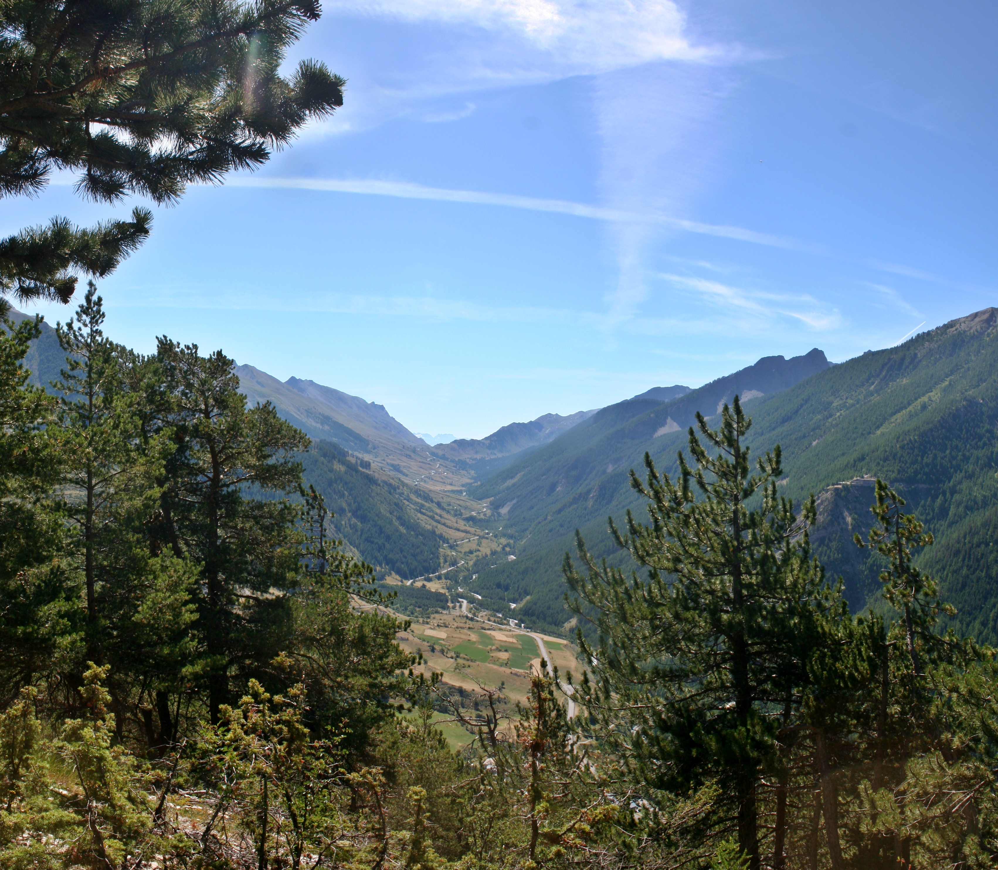
English: The Ubayette valley, as seen fron the serre de la platte ridge. On the background, the Larche mountain pass on the french-italian border is visible. The Ubayette springs lie in the Lauzanier valley. The entering of the Lauzanier valley is visible on the right bellow the pass. Another visible feature is the opposition between the sunny side (locally called Adret, here on the left), and the shadowed side (locally called Ubac, on the right of the picture). The sunny side was historically deforested and cultivated, and stil is partially cultivated today. It also habors all the villages and hamlets existing in the valley, plus the road. The shadowed side is covered by a forest of larches. Alpes-de-Haute-Provence département, France.
Français : La vallée de l'Ubayette, vue depuis le serre de la platte. Au fond, on distingue le col frontalier de Larche. L'Ubayette prend sa source dans le vallon du Lausanier, dont on devine l'entrée à droite sous le col. l'asymétrie entre l'adret (ici à gauche) et l'ubac (ici à droite) est très visible sur cette photo. L'adret a été déboisé et est encore partiellement cultivé. Les villages se développent sur ce versant qu'emprunte aussi la route. L'ubac est entièrement recouvert de mélèzes. Alpes-de-Haute-Provence, France.
|
| Date | |
| Source | Own work |
| Author | Berrucomons |
| Camera location | View this and other nearby images on: OpenStreetMap - Google Earth |
|---|
Licensingedit
|
I, the copyright holder of this work, hereby publish it under the following licenses:
You may select the license of your choice.
|

|
This image has been assessed using the Quality image guidelines and is considered a Quality image. |
GNU Free Documentation License
| EXIF data: | |
| File name | valla_e_ubayette.jpg |
|---|---|
| Size, Mbytes | 7.0089677734375 |
| Mime type | image/jpeg |
While the copyright and licensing information supplied for each photo is believed to be accurate, Free-Photos.biz does not provide any warranty regarding the copyright status or correctness of licensing terms. If you decide to reuse the images from Free-Photos.biz, you should verify the copyright status of each image just as you would when obtaining images from other sources.
The use of depictions of living or deceased persons may be restricted in some jurisdictions by laws regarding personality rights. Such images are exhibited at Free-Photos.biz as works of art that serve higher artistic interests.
PRIVACY POLICY
By registering your account and/or by subscribing to new and newly rated photographs you agree we may send you the links to photos and we may occasionally share other information with you.
We do NOT disclose your personal data.
