

Please login in order to download photos in full size
If you are not registered, please register for free: www.Free-Photos.biz/register
Please note to download premium images you also need to join as a free member..
You can also save the photos without the registration - but only in small and average sizes, and some of them will have the site's watermark. Please simply click your right mouse button and save the image.
Please login in order to like photos
If you are not registered, please register for free:
Sorry, non-members can download up to 1100 full-size photos per month.
It looks like you have used up your limit.
Free members can download an unlimited number of full-size photos - including the premium free photos.
Join as a member today for FREE! - and download the images without limitations:
www.Free-Photos.biz/membership.php
You can also save the images without the membership - but only in small and average sizes, and some of them may have the site's watermark. Please simply click your right mouse button and save the image.
|
This is a premium free photo
This photo was viewed 2 times and was downloaded in full size 1 times.
This photo was liked 0 times


If you are a member, please login in order to see the source link of the above image.
| Description |
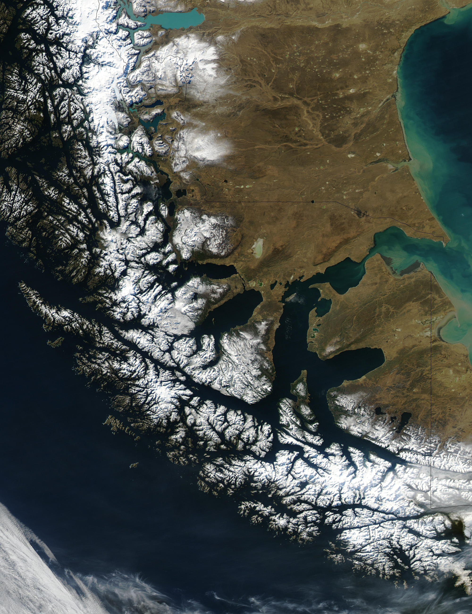
Español: Estrecho de Magallanes y territorio sur de los kawésqar
English: Until the Panama Canal was finished in 1914, the Strait of Magellan was the only safe way to move between the Atlantic and Pacific Oceans. Protected by the Tierra del Fuego to the south and the bulk of South America to the north, ships crossed in relative ease, removed from the dangers of Drake Passage. Drake Passage is the relatively narrow stretch of ocean separating South America from Antarctica, the waters of which are notoriously turbulent, unpredictable, and frequented by icebergs and sea ice. In this unusually clear true-color Moderate Resolution Imaging Spectroradiometer (MODIS) image, the entire Strait is visible. The eastern opening is the wide bay on the border of Chile and Argentina. To the west, there are a number of access points from the Pacific, though the most easily seen here is the roughly 200 km stretch from the Queen Adelaide Archipelago (at center left) to the bulk of the Strait (at lower center). The islands and mountains are highlighted by bright white snow, while the lower-elevation lands to the north and east remain clear. This image was acquired by the Aqua satellite on August 27, 2003.
Русский: До Панамского канала, завершённого в 1914 году, Магелланов пролив был единственным безопасным маршрутом, соединяющим Атлантический и Тихий океаны. Защищённые Огненной Землёй на юге и материковой часть Южной Америки на севере, корабли передвигались с относительной легкостью, в удалении от опасностей пролива Дрейка. Пролив Дрейка (часто пролив относят к Южному океану) является сравнительно узким участком океана, разделяющий Южную Америку и Антарктиду, в водах которого часты бури и появление айсбергов и морских льдов.
Изображение получено с помощью спектрорадиометра среднего разрешения MODIS (Moderate-Resolution Imaging Spectroradiometer). На востоке расположен широкий залив, на границе Чили и Аргентины. С западной стороны есть несколько точек входа из Тихого океана, хотя самый легко заметный протянулся примерно на 200 км вдоль архипелага королевы Аделаиды (слева в центре) до основной части пролива (ниже центра). Острова и горы на западе покрыты белым снегом, а на более пологой местности к северу и востоку снега нет. Это изображение было получено спутником Aqua 27 августа 2003 года. |
| Date | |
| Source | https://visibleearth.nasa.gov/view_rec.php?id=6092
|
| Author | Jacques Descloitres, MODIS Rapid Response Team, NASA/GSFC |
Licensingedit
| This file is in the public domain because it was solely created by NASA. NASA copyright policy states that "NASA material is not protected by copyright unless noted". (See Template:PD-USGov, NASA copyright policy page or JPL Image Use Policy.) |
|
 |
Warnings:
|
Public Domain
| EXIF data: | |
| File name | straitofmagellan.jpg |
|---|---|
| Size, Mbytes | 0.9333994140625 |
| Mime type | image/jpeg |
While the copyright and licensing information supplied for each photo is believed to be accurate, Free-Photos.biz does not provide any warranty regarding the copyright status or correctness of licensing terms. If you decide to reuse the images from Free-Photos.biz, you should verify the copyright status of each image just as you would when obtaining images from other sources.
The use of depictions of living or deceased persons may be restricted in some jurisdictions by laws regarding personality rights. Such images are exhibited at Free-Photos.biz as works of art that serve higher artistic interests.
PRIVACY POLICY
By registering your account and/or by subscribing to new and newly rated photographs you agree we may send you the links to photos and we may occasionally share other information with you.
We do NOT disclose your personal data.
