

Please login in order to download photos in full size
If you are not registered, please register for free: www.Free-Photos.biz/register
Please note to download premium images you also need to join as a free member..
You can also save the photos without the registration - but only in small and average sizes, and some of them will have the site's watermark. Please simply click your right mouse button and save the image.
Please login in order to like photos
If you are not registered, please register for free:
Sorry, non-members can download up to 1100 full-size photos per month.
It looks like you have used up your limit.
Free members can download an unlimited number of full-size photos - including the premium free photos.
Join as a member today for FREE! - and download the images without limitations:
www.Free-Photos.biz/membership.php
You can also save the images without the membership - but only in small and average sizes, and some of them may have the site's watermark. Please simply click your right mouse button and save the image.
|
This is a premium free photo
This photo was viewed 2 times and was downloaded in full size 0 times.
This photo was liked 0 times


If you are a member, please login in order to see the source link of the above image.
|
|
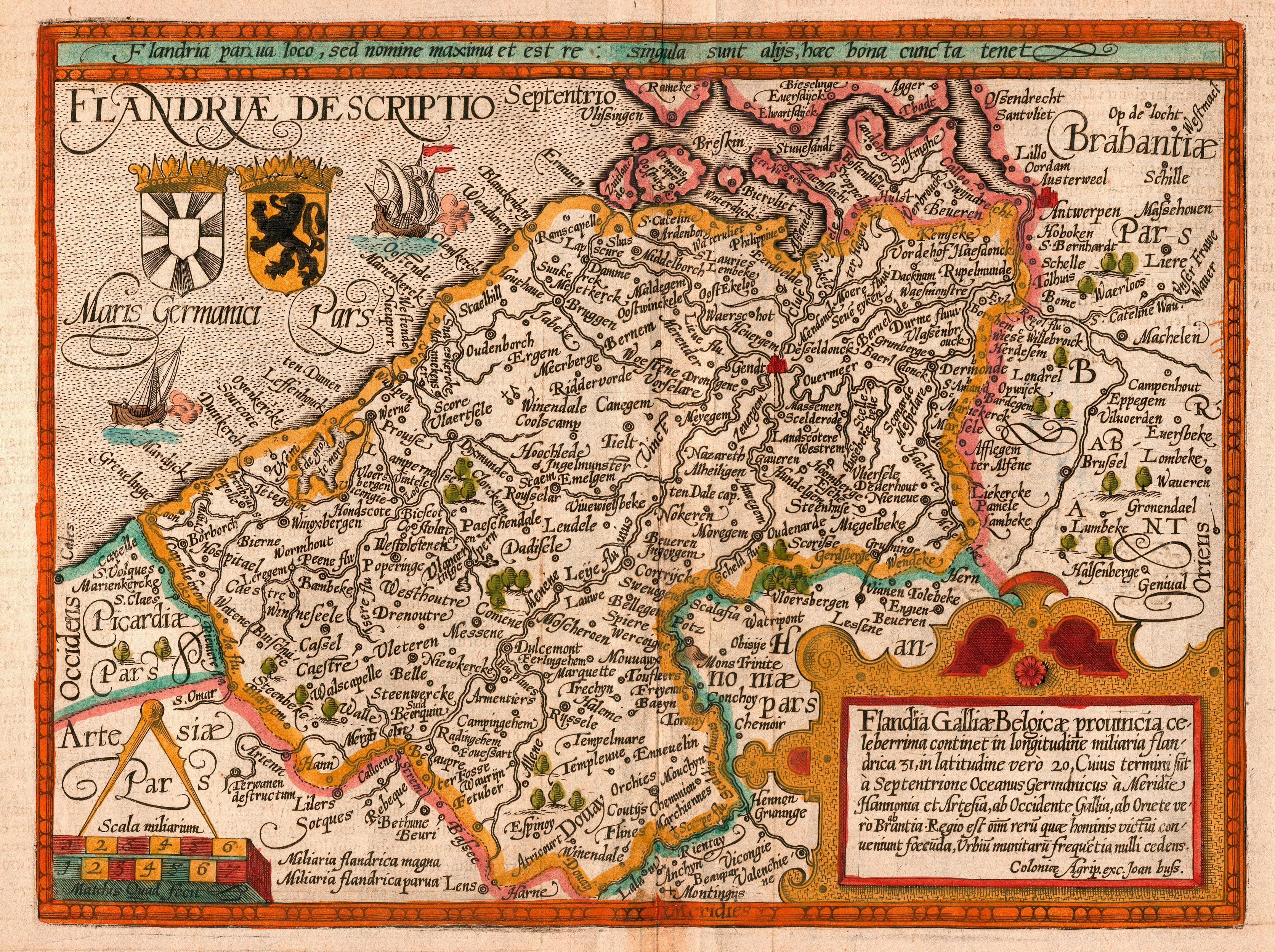
This image was selected as picture of the day on Wikimedia Commons for . It was captioned as follows: English: Map of the county of Flanders by 1609
Alemannisch: Charte vo Flandern (Belgiä) us em Jahr 1609.
العربية: خريطة دولة فلندرز عام 1609.
Беларуская: Карта Фландрыі (1609)
Bosanski: Karta Grofovije Flandrija iz 1609.
Česky: Mapa Vévodství Flandry z roku 1609
Dansk: Kort over Flandern (Belgien) i 1609.
Deutsch: Karte von Flandern (Belgien) aus dem Jahre 1609.
English: Map of the county of Flanders by 1609
فارسی: نقشه کشور فلندرز در 1609
Français : Carte de la Flandre
Magyar: Flandria térképe 1609-ből, Matthias Quad térképész és Johannes Bussemacher grafikus és kiadó (Köln) munkája
Íslenska: Kort af Flandri árið 1609.
Italiano: Mappa delle Fiandre del 1609.
日本語: 1609年のフランドル地域の地図
한국어: 1609년에 그려진 플란데런 지도.
Polski: Mapa hrabstwa Flandrii wykonana około roku 1609.
Русский: Карта Фландрии 1609 года
Српски / srpski: Мапа Фландрије из 1609. године.
Svenska: Grevskapet Flandern på en karta från 1609.
Türkçe: Flanders kontluğunun 1609'daki haritası
Українська: Карта Фландрії 1609 року
中文(简体): 佛兰德伯国1609年地图
中文(繁體): 佛蘭德伯國1609年地圖
|
Summary
| Description |
English: Map of the county of Flanders by Matthias Quad (cartographer) and Johannes Bussemacher (engraver & publisher, Cologne)
Nederlands: Kaart van het graafschap Vlaanderen door Matthias Quad (kartograaf) en Johannes Bussemacher (graveur en uitgever, Keulen)
Français : Carte du comté de Flandre par Matthias Quad (cartographe) et Johannes Bussemacher (graveur et éditeur, Cologne)
Español: Mapa del condado de Flandes, de Matthias Quad (cartógrafo) y Johannes Bussemacher (grabador y editor, Colonia, Alemania)
|
| Date | |
| Source | eigen werk (scan) |
| Author | Matthias Quad (†1613) and Johannes Bussemacher / scanned by Marc Ryckaert (MJJR) |
Licensing
| This image (or other media file) is in the public domain because its copyright has expired. This applies to Australia, the European Union and those countries with a copyright term of life of the author plus 70 years.
|
|
|
|
|
Public Domain
| EXIF data: | |
| File name | quad_flandria.jpg |
|---|---|
| Size, Mbytes | 7.7090703125 |
| Mime type | image/jpeg |
| Orientation of image | 1 |
| Image resolution in width direction | 300 |
| Image resolution in height direction | 300 |
| Unit of X and Y resolution | 2 |
| Color space information | 65535 |
| Exif image width | 3345 |
| Exif image length | 2498 |
| Software used | Adobe Photoshop 7.0 |
While the copyright and licensing information supplied for each photo is believed to be accurate, Free-Photos.biz does not provide any warranty regarding the copyright status or correctness of licensing terms. If you decide to reuse the images from Free-Photos.biz, you should verify the copyright status of each image just as you would when obtaining images from other sources.
The use of depictions of living or deceased persons may be restricted in some jurisdictions by laws regarding personality rights. Such images are exhibited at Free-Photos.biz as works of art that serve higher artistic interests.
PRIVACY POLICY
By registering your account and/or by subscribing to new and newly rated photographs you agree we may send you the links to photos and we may occasionally share other information with you.
We do NOT disclose your personal data.
