

Please login in order to download photos in full size
If you are not registered, please register for free: www.Free-Photos.biz/register
Please note to download premium images you also need to join as a free member..
You can also save the photos without the registration - but only in small and average sizes, and some of them will have the site's watermark. Please simply click your right mouse button and save the image.
Please login in order to like photos
If you are not registered, please register for free:
Sorry, non-members can download up to 1100 full-size photos per month.
It looks like you have used up your limit.
Free members can download an unlimited number of full-size photos - including the premium free photos.
Join as a member today for FREE! - and download the images without limitations:
www.Free-Photos.biz/membership.php
You can also save the images without the membership - but only in small and average sizes, and some of them may have the site's watermark. Please simply click your right mouse button and save the image.
|
This is a premium free photo
This photo was viewed 1 times and was downloaded in full size 0 times.
This photo was liked 0 times


If you are a member, please login in order to see the source link of the above image.
| Artist |
|
|||||||||||||
| Title |
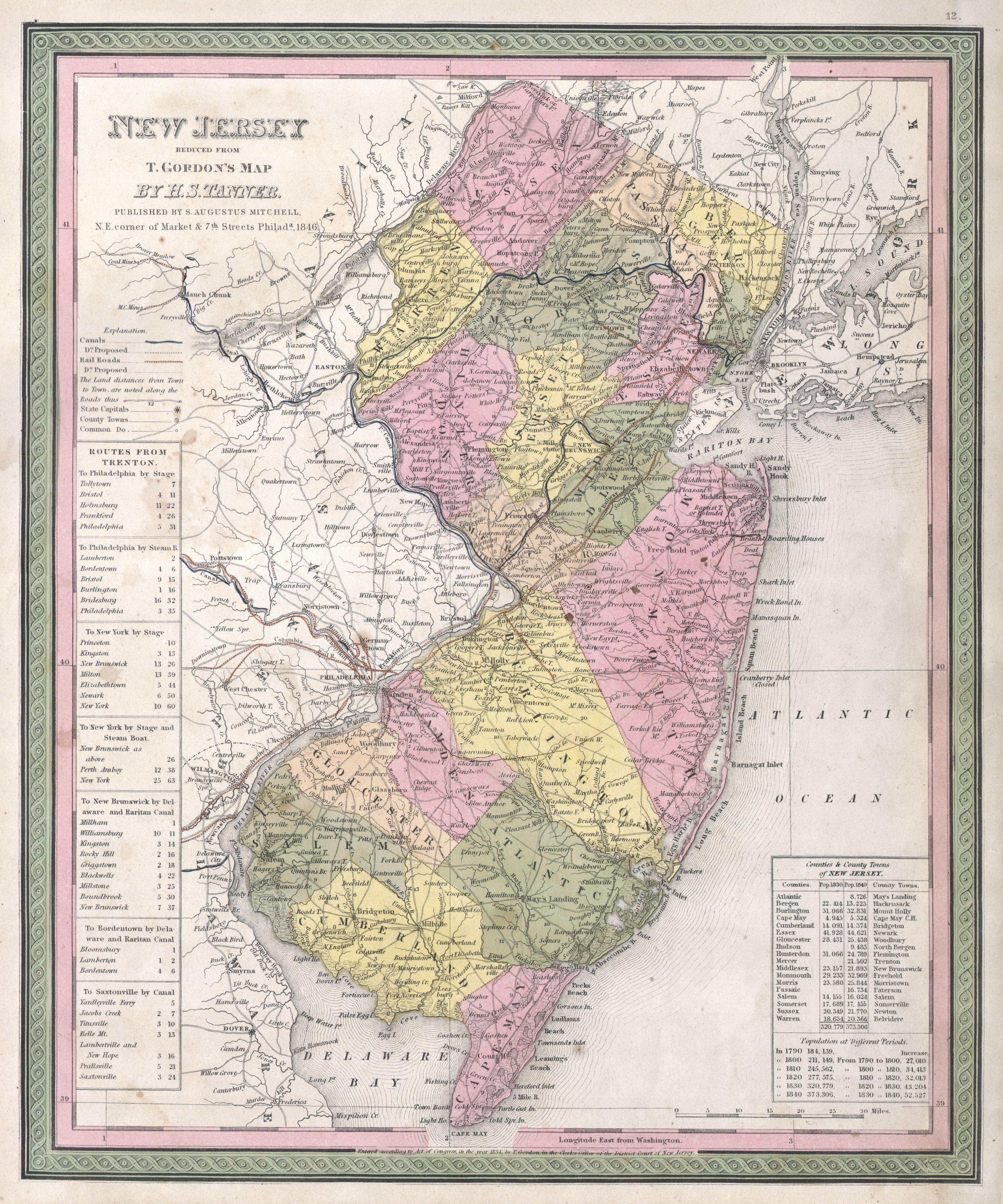
New Jersey reduced from T. Gordon's Map by H. S. Tanner, Published by S. Augustus Mitchell. |
|||||||||||||
| Description |
English: A fine example of Mitchell’s c. 1846 map New Jersey. A highly unusual state of this map. In 1846 Mitchell published two editions of the New Universal Atlas , one edition with the Cary and Hart imprint and borders and another with his own Mitchell imprint and slightly different borders. The Rumsey example, from the first, 1846 issue of the atlas, features the Cary and Hart borders. This issue, though cartographically identical and maintaining the 1846 date, has borders more common in later Mitchell Atlases. However, the copyright on the map remains the same as the earlier Tanner maps – in this instance “T. Gordon”. The map itself is based upon Tanner’s 1834 reduction of Thomas Gordon’s seminal 1828 Map of New Jersey. Prepared for inclusion as map no. 12 in the 1847 issue of Mitchell’s New General Atlas . Dated and copyrighted, “Entered according to Act of Congress in the Year 1834 by T. Gordon in the Clerk’s Office of the District Court of New Jersey.
|
|||||||||||||
| Date |
1846 (dated) |
|||||||||||||
| Dimensions |
Height: 15 in (38.1 cm). Width: 12.5 in (31.8 cm). |
|||||||||||||
| Accession number |
Geographicus code: NewJersey-mitchell-1848 |
|||||||||||||
| Source/Photographer |
A New Universal Atlas Containing Maps of the various Empires, Kingdoms, States and Republics Of The World. (1846 Mitchell issue)
|
|||||||||||||
| Permission (Reusing this file) |
|
|||||||||||||
Public Domain
| EXIF data: | |
| File name | 1846_mitchell_-_tanner_map_of_new_jersey_-_geographicus_-_newjersey-mitchell-1848.jpg |
|---|---|
| Size, Mbytes | 3.396943359375 |
| Mime type | image/jpeg |
While the copyright and licensing information supplied for each photo is believed to be accurate, Free-Photos.biz does not provide any warranty regarding the copyright status or correctness of licensing terms. If you decide to reuse the images from Free-Photos.biz, you should verify the copyright status of each image just as you would when obtaining images from other sources.
The use of depictions of living or deceased persons may be restricted in some jurisdictions by laws regarding personality rights. Such images are exhibited at Free-Photos.biz as works of art that serve higher artistic interests.
PRIVACY POLICY
By registering your account and/or by subscribing to new and newly rated photographs you agree we may send you the links to photos and we may occasionally share other information with you.
We do NOT disclose your personal data.
