

Please login in order to download photos in full size
If you are not registered, please register for free: www.Free-Photos.biz/register
Please note to download premium images you also need to join as a free member..
You can also save the photos without the registration - but only in small and average sizes, and some of them will have the site's watermark. Please simply click your right mouse button and save the image.
Please login in order to like photos
If you are not registered, please register for free:
Sorry, non-members can download up to 1100 full-size photos per month.
It looks like you have used up your limit.
Free members can download an unlimited number of full-size photos - including the premium free photos.
Join as a member today for FREE! - and download the images without limitations:
www.Free-Photos.biz/membership.php
You can also save the images without the membership - but only in small and average sizes, and some of them may have the site's watermark. Please simply click your right mouse button and save the image.
|
This is a premium free photo
This photo was viewed 6 times and was downloaded in full size 2 times.
This photo was liked 0 times


If you are a member, please login in order to see the source link of the above image.
This image was improved or created by the Wikigraphists of the Graphic Lab (fr). You can propose images to clean up, improve, create or translate as well.
Català | ?esky | Deutsch | ?Deutsch (Sie-Form)? | ???????? | English | Esperanto | Español | Suomi | Français | Magyar | ??????? | Italiano | ?????????? | Plattdüütsch | Occitan | Polski | Português | ??????? | Svenska | ???????/Tatarça | Türkçe | ?????????? | ?? | ???(??)? | ???(??)? | Zazaki | +/?
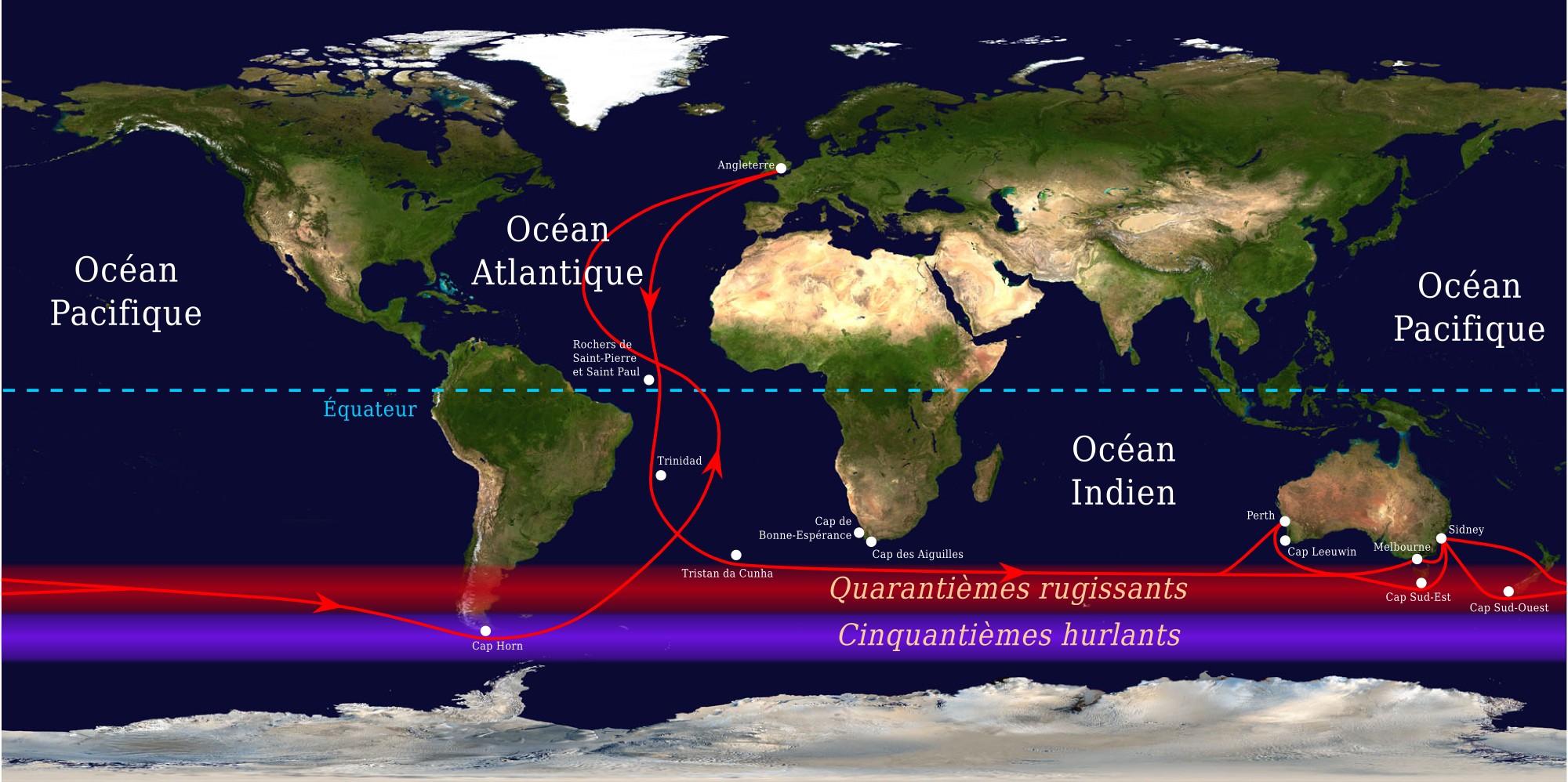
fr : Routes commerciales empruntées par les navires entre l'Angleterre et l'Australie/Nouvelle Zélande du XVIIIe au XXe siècle. Dessiné par Jérôme BLUM le 22 juillet 2006, inspiré par la version anglaise. La carte de fond est dans le domaine public. Elle est issue du projet Visible Earth de l'observatoire de la Terre de la NASA. L'image originale provient de cette page.
en : The clipper route sailed by ships between England and Australia/New Zealand. Drawn by Jérôme BLUM on 22 july 2006, inspired by the english version. This image was constructed from a public domain Visible Earth product of the Earth Observatory office of the United States government space agency NASA. Original image can be found at this page.
| This bitmap image was downsampled from an Inkscape vectorial image, causing some loss of quality. Try asking the author for the SVG source. |
Licensing
From the source image :
|

GNU Free Documentation License
| EXIF data: | |
| File name | routes_commerciales_maritimes.jpg |
|---|---|
| Size, Mbytes | 0.3683642578125 |
| Mime type | image/jpeg |
While the copyright and licensing information supplied for each photo is believed to be accurate, Free-Photos.biz does not provide any warranty regarding the copyright status or correctness of licensing terms. If you decide to reuse the images from Free-Photos.biz, you should verify the copyright status of each image just as you would when obtaining images from other sources.
The use of depictions of living or deceased persons may be restricted in some jurisdictions by laws regarding personality rights. Such images are exhibited at Free-Photos.biz as works of art that serve higher artistic interests.
PRIVACY POLICY
By registering your account and/or by subscribing to new and newly rated photographs you agree we may send you the links to photos and we may occasionally share other information with you.
We do NOT disclose your personal data.
