

Please login in order to download photos in full size
If you are not registered, please register for free: www.Free-Photos.biz/register
Please note to download premium images you also need to join as a free member..
You can also save the photos without the registration - but only in small and average sizes, and some of them will have the site's watermark. Please simply click your right mouse button and save the image.
Please login in order to like photos
If you are not registered, please register for free:
Sorry, non-members can download up to 1100 full-size photos per month.
It looks like you have used up your limit.
Free members can download an unlimited number of full-size photos - including the premium free photos.
Join as a member today for FREE! - and download the images without limitations:
www.Free-Photos.biz/membership.php
You can also save the images without the membership - but only in small and average sizes, and some of them may have the site's watermark. Please simply click your right mouse button and save the image.
|
This is a premium free photo
This photo was viewed times and was downloaded in full size 0 times.
This photo was liked 0 times


If you are a member, please login in order to see the source link of the above image.
| Artist | ||||||
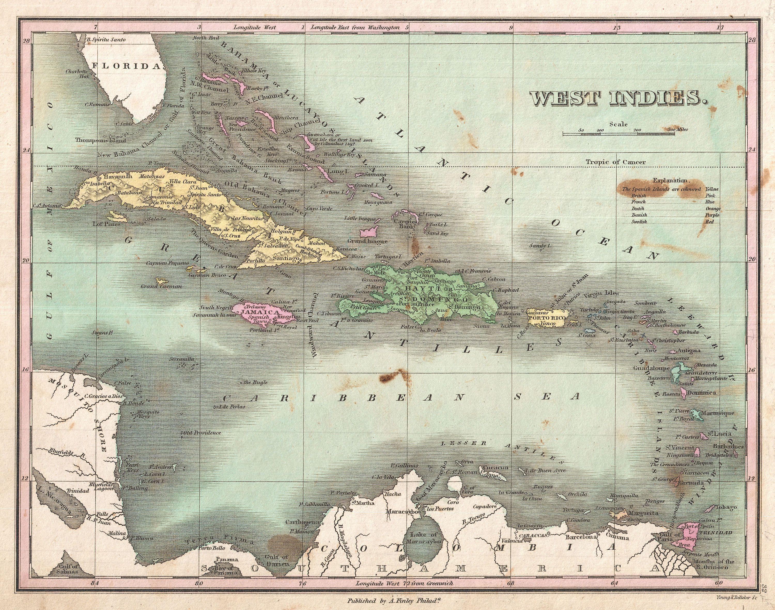
| Title | West Indies. | |||||
| Description |
English: This is Finley’s desirable 1827 map of the West Indies and Caribbean. Shows the Greater and LEsser Antilles as well as the Bahamas and portions of the Spanish Main. Islands are color coded according to their European claimants. Shows cities, forts, bays, rivers, roads, and some topographical features. It the Bahamas, Finley identifies Guanaham or Cat Isle, the first land in the America to be sighted by Columbus. Mile scales and title in upper right quadrant. Engraved by Young and Delleker for the 1827 edition of Anthony Finley's General Atlas .
|
|||||
| Date | (undated) | |||||
| Dimensions | Height: 9 in (22.9 cm). Width: 11.5 in (29.2 cm). | |||||
| Accession number | Geographicus code: WestIndies-finley-1827 | |||||
| Source/Photographer |
Finley, Anthony, A New General Altas, Comprising a Complete Set of Maps, representing the Grand Divisions of the Globe, Together with the several Empires, Kingdoms and States in the World; Compiled from the Best Authorities, and corrected by the Most Recent Discoveries, Philadelphia, 1827.
|
|||||
| Permission (Reusing this file) |
|
|||||
See alsoedit
- Alternative map of early 1800s West Indies:

Public Domain
| EXIF data: | |
| File name | 1827_finley_map_of_the_west_indies__caribbean__and_antilles_-_geographicus_-_westindies-finley-1827.jpg |
|---|---|
| Size, Mbytes | 2.1741572265625 |
| Mime type | image/jpeg |
While the copyright and licensing information supplied for each photo is believed to be accurate, Free-Photos.biz does not provide any warranty regarding the copyright status or correctness of licensing terms. If you decide to reuse the images from Free-Photos.biz, you should verify the copyright status of each image just as you would when obtaining images from other sources.
The use of depictions of living or deceased persons may be restricted in some jurisdictions by laws regarding personality rights. Such images are exhibited at Free-Photos.biz as works of art that serve higher artistic interests.
PRIVACY POLICY
By registering your account and/or by subscribing to new and newly rated photographs you agree we may send you the links to photos and we may occasionally share other information with you.
We do NOT disclose your personal data.
