

Please login in order to download photos in full size
If you are not registered, please register for free: www.Free-Photos.biz/register
Please note to download premium images you also need to join as a free member..
You can also save the photos without the registration - but only in small and average sizes, and some of them will have the site's watermark. Please simply click your right mouse button and save the image.
Please login in order to like photos
If you are not registered, please register for free:
Sorry, non-members can download up to 1100 full-size photos per month.
It looks like you have used up your limit.
Free members can download an unlimited number of full-size photos - including the premium free photos.
Join as a member today for FREE! - and download the images without limitations:
www.Free-Photos.biz/membership.php
You can also save the images without the membership - but only in small and average sizes, and some of them may have the site's watermark. Please simply click your right mouse button and save the image.
|
This is a premium free photo
This photo was viewed times and was downloaded in full size 0 times.
This photo was liked 0 times


If you are a member, please login in order to see the source link of the above image.
| Artist | ||||||
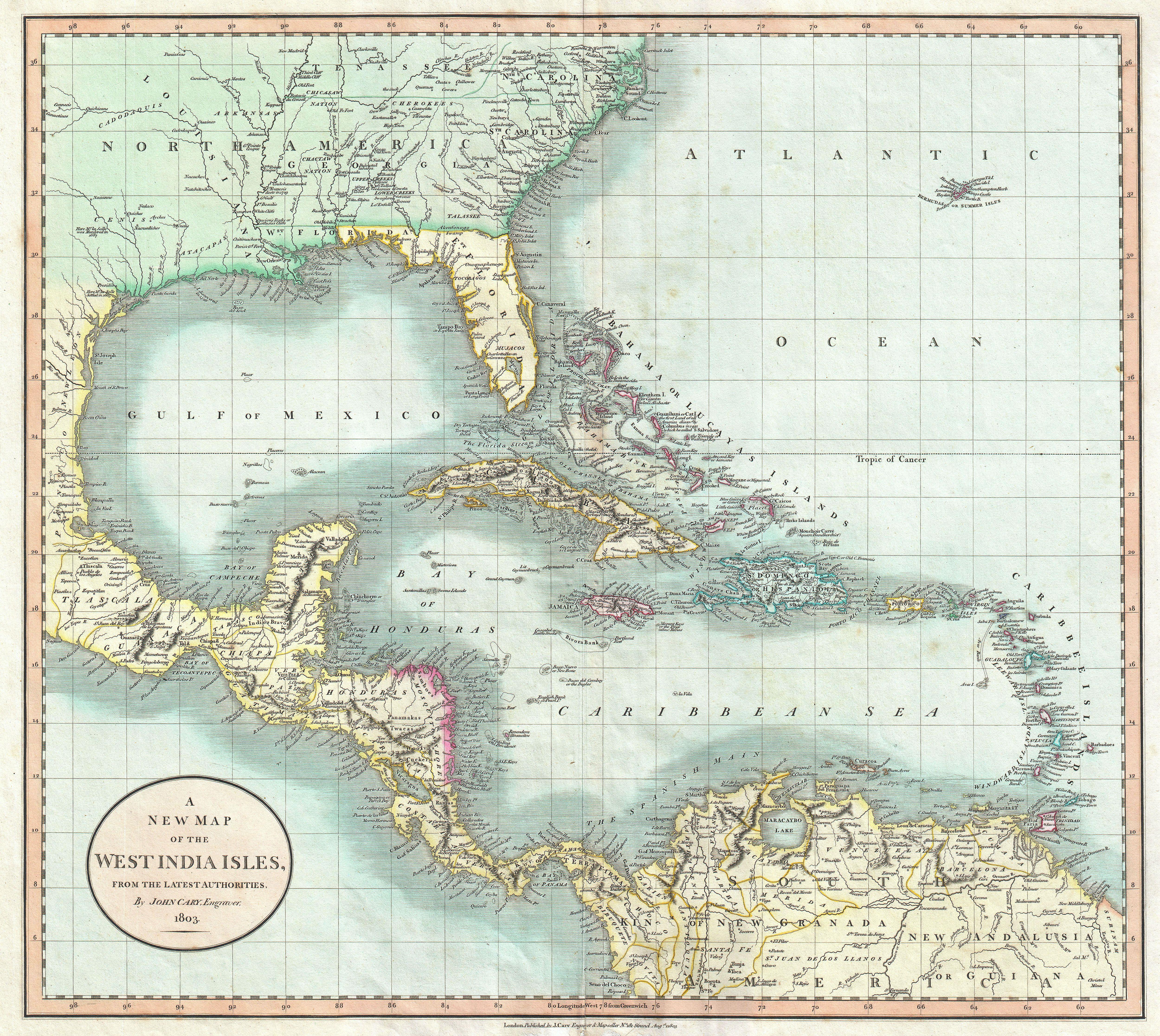
| Title | A New Map of the West India Isles. | |||||
| Description |
English: A beautiful example of John Cary’s important 1803 map of Florida, Central America and the West Indies. Covers from Texas (called Cenis) eastward to the Carolinas and the Bahamas, and then southward past Florida and the West Indies to include all of Central America and the northern part of South America. Offers superb detail throughout, especially regarding Florida and the Caribbean. In the North America section of the map Georgia is shown extending westward as far as the Mississippi River despite the creation of the Mississippi Territory in 1798. Florida is divided at the Apalachicola River into eastern and western sections. West Florida, ostensibly part of the Louisiana Purchase, was claimed by the Spanish and remained under their control until 1812. Lists numerous place names along the Mississippi River including Davion’s Rocks, Ft. Bosalie, Ft. Francis (destroyed in 1729), New Madrid and Old Fort, among others. In modern day Texas, called Cenis here, Cary lists eight place names as well as both the 1685 settlement founded by La Salle on the Gulf coast, and the place further inland where, in 1687, he was murdered. All in all, one of the most interesting and attractive atlas maps of the West Indies to appear in first ten years of the 19th century. Prepared in 1803 by John Cary for issue in his magnificent 1808 New Universal Atlas .
|
|||||
| Date | (dated) | |||||
| Dimensions | Height: 18.25 in (46.4 cm). Width: 20.5 in (52.1 cm). | |||||
| Accession number | Geographicus code: WestIndies-cary-1803 | |||||
| Source/Photographer |
Cary, John, Cary's New Universal Atlas, containing distinct maps of all the principal states and kingdoms throughout the World. From the latest and best authorities extant. London: Printed for J. Cary, Engraver and Map-seller, No. 181, near Norfolk Street, Strand, 1808.
|
|||||
| Permission (Reusing this file) |
|
|||||
Public Domain
| EXIF data: | |
| File name | 1803_cary_map_of_florida__central_america__the_bahamas__and_the_west_indies_-_geographicus_-_westindies-cary-1803.jpg |
|---|---|
| Size, Mbytes | 7.1523759765625 |
| Mime type | image/jpeg |
While the copyright and licensing information supplied for each photo is believed to be accurate, Free-Photos.biz does not provide any warranty regarding the copyright status or correctness of licensing terms. If you decide to reuse the images from Free-Photos.biz, you should verify the copyright status of each image just as you would when obtaining images from other sources.
The use of depictions of living or deceased persons may be restricted in some jurisdictions by laws regarding personality rights. Such images are exhibited at Free-Photos.biz as works of art that serve higher artistic interests.
PRIVACY POLICY
By registering your account and/or by subscribing to new and newly rated photographs you agree we may send you the links to photos and we may occasionally share other information with you.
We do NOT disclose your personal data.
