

Please login in order to download photos in full size
If you are not registered, please register for free: www.Free-Photos.biz/register
Please note to download premium images you also need to join as a free member..
You can also save the photos without the registration - but only in small and average sizes, and some of them will have the site's watermark. Please simply click your right mouse button and save the image.
Please login in order to like photos
If you are not registered, please register for free:
Sorry, non-members can download up to 1100 full-size photos per month.
It looks like you have used up your limit.
Free members can download an unlimited number of full-size photos - including the premium free photos.
Join as a member today for FREE! - and download the images without limitations:
www.Free-Photos.biz/membership.php
You can also save the images without the membership - but only in small and average sizes, and some of them may have the site's watermark. Please simply click your right mouse button and save the image.
|
This is a premium free photo
This photo was viewed 3 times and was downloaded in full size 0 times.
This photo was liked 0 times


If you are a member, please login in order to see the source link of the above image.
Summaryedit
| Artist |
|
|||||||||||||||||||
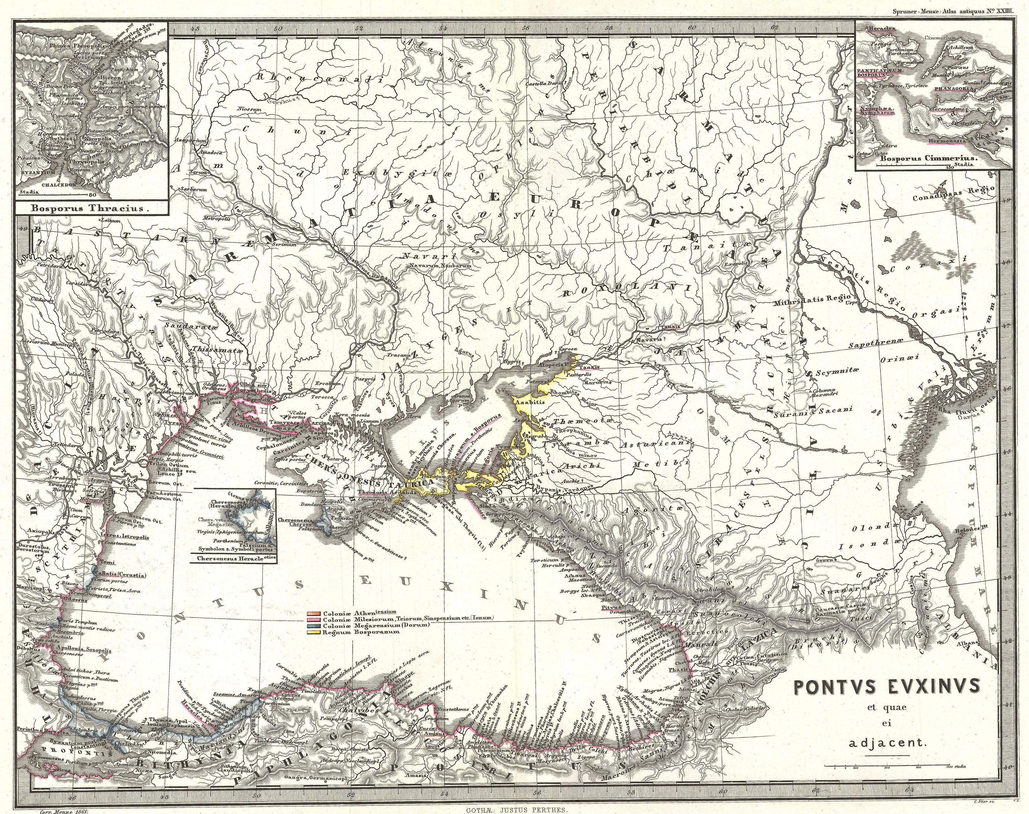
| Title | Pontus Euxinus et quae ei adjacent. | |||||||||||||||||||
| Description |
English: This is Karl von Spruner’s 1865 map of the Black Sea and adjacent regions (Pontus Euxinus et quae ei Adjacent). This detailed map focuses on the Black Sea and the area immediately surrounding it, including what is modern day Ukraine, the southern-most portion of Russia, and northern Turkey. Spruner also includes two detailed insets of Thrace (Thracia) and the Crimea (Cimmerius.) Thrace is a historical and geographical region in Southeast Europe. The areas it comprises are southeastern Bulgaria (Northern Thrace), northeastern Greece (Western Thrace), and the European part of Turkey (Eastern Thrace). Crimea is a peninsular region north of the Caucasus and the Black Sea attached to modern day Ukraine. The map shows important cities, rivers, mountain ranges and other minor topographical detail. Countries and territories are designated with colored borders and each map includes a key or legend. The whole is rendered in finely engraved detail exhibiting throughout the fine craftsmanship of the Perthes firm.
|
|||||||||||||||||||
| Date | (undated) | |||||||||||||||||||
| Dimensions | Height: 13 in (33 cm). Width: 16 in (40.6 cm). | |||||||||||||||||||
| Accession number | Geographicus code: PontusEuxinus-spruner-1865 | |||||||||||||||||||
| Source/Photographer |
Spruner, Karl von, Spruner-Menke Atlas Antiquus,, (Gotha: Justus Perthes), 1865.
|
|||||||||||||||||||
| Permission (Reusing this file) |
|
|||||||||||||||||||
Licensingedit
This photographic reproduction is therefore also considered to be in the public domain. In other jurisdictions, re-use of this content may be restricted; see Reuse of PD-Art photographs for details. |
||||
Public Domain
| EXIF data: | |
| File name | 1865_spruner_map_of_the_black_sea_and_adjacent_regions_-_geographicus_-_pontuseuxinus-spruner-1865.jpg |
|---|---|
| Size, Mbytes | 2.628787109375 |
| Mime type | image/jpeg |
While the copyright and licensing information supplied for each photo is believed to be accurate, Free-Photos.biz does not provide any warranty regarding the copyright status or correctness of licensing terms. If you decide to reuse the images from Free-Photos.biz, you should verify the copyright status of each image just as you would when obtaining images from other sources.
The use of depictions of living or deceased persons may be restricted in some jurisdictions by laws regarding personality rights. Such images are exhibited at Free-Photos.biz as works of art that serve higher artistic interests.
PRIVACY POLICY
By registering your account and/or by subscribing to new and newly rated photographs you agree we may send you the links to photos and we may occasionally share other information with you.
We do NOT disclose your personal data.
