

Please login in order to download photos in full size
If you are not registered, please register for free: www.Free-Photos.biz/register
Please note to download premium images you also need to join as a free member..
You can also save the photos without the registration - but only in small and average sizes, and some of them will have the site's watermark. Please simply click your right mouse button and save the image.
Please login in order to like photos
If you are not registered, please register for free:
Sorry, non-members can download up to 1100 full-size photos per month.
It looks like you have used up your limit.
Free members can download an unlimited number of full-size photos - including the premium free photos.
Join as a member today for FREE! - and download the images without limitations:
www.Free-Photos.biz/membership.php
You can also save the images without the membership - but only in small and average sizes, and some of them may have the site's watermark. Please simply click your right mouse button and save the image.
|
This is a premium free photo
This photo was viewed 2 times and was downloaded in full size 2 times.
This photo was liked 0 times


Source page: |
http://commons.wikimedia.org/wiki/File:Clouds_off_the_Aleutian_Islands.jpg |
|---|
| Description |
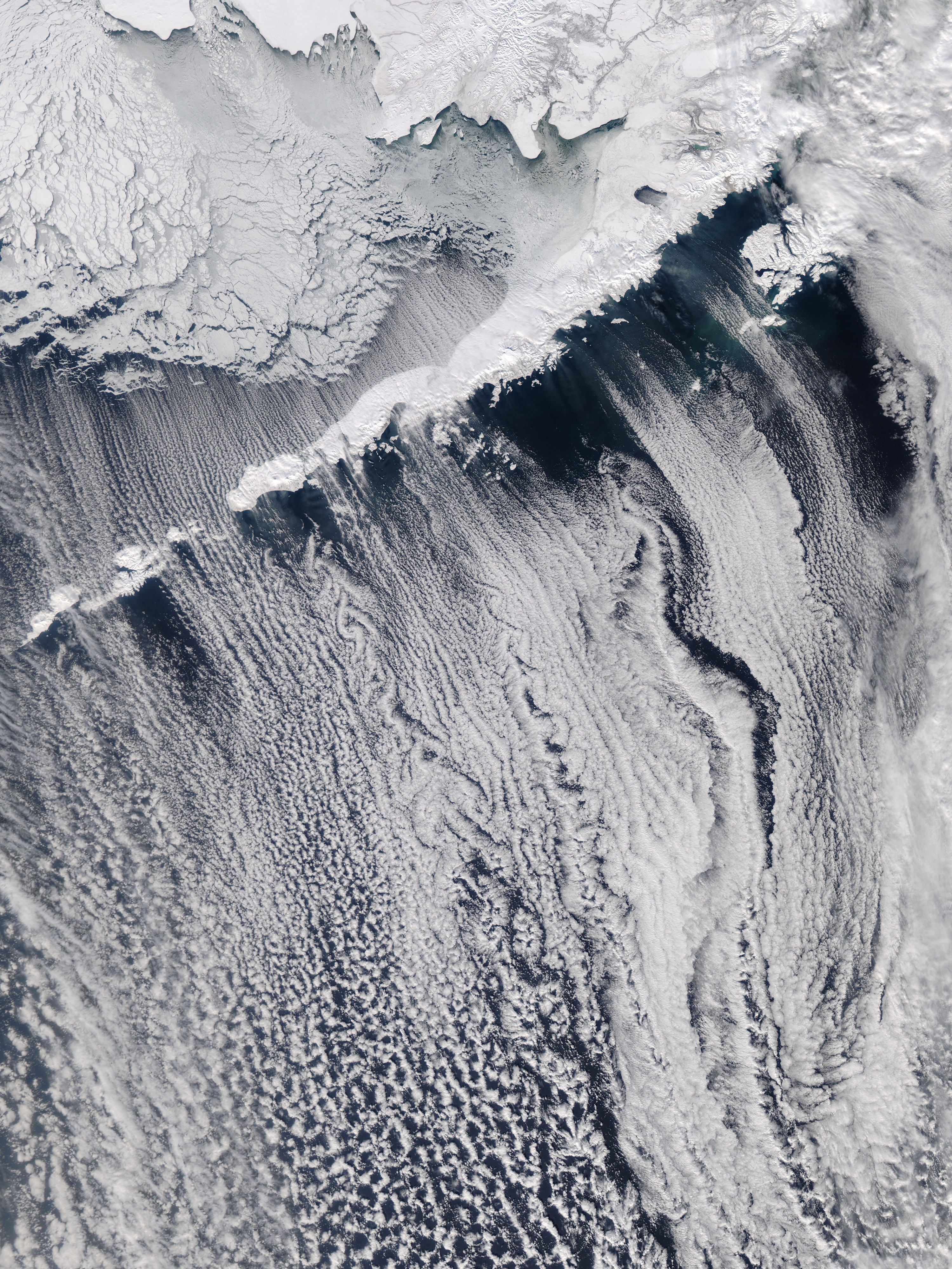
"March 23, 2010 - Clouds off the Aleutian Islands Interesting cloud patterns were visible over the Aleutian Islands and the Alaska Peninsula in this image, captured by the MODIS on the Aqua satellite on March 14, 2010. Turbulence, caused by the wind passing over the highest points of the islands, is producing the pronounced eddies that swirl the clouds into a pattern called a vortex "street". In this image, the clouds have also aligned in parallel rows or streets. Cloud streets form when low-level winds move between and over obstacles causing the clouds to line up into rows (much like streets) that match the direction of the winds. At the point where the clouds first form streets, they're very narrow and well-defined. But as they age, they lose their definition, and begin to spread out and rejoin each other into a larger cloud mass. The Aleutians are a chain of islands that extend from Alaska toward the Kamchatka Peninsula in Russia and here separate the Bering Sea from the Gulf of Alaska.
<a href="https://modis.gsfc.nasa.gov/gallery/individual.php?db_date=2010-03-23" rel="nofollow">modis.gsfc.nasa.gov/gallery/individual.php?db_date=2010-0...</a>
<a href="https://www.nasa.gov/centers/goddard/home/index.html" rel="nofollow">www.nasa.gov/centers/goddard/home/index.html</a>" |
|||||||
| Date | ||||||||
| Source | Flickr: Clouds off the Aleutian Islands | |||||||
| Author | NASA Goddard Space Flight Center | |||||||
| Permission (Reusing this file) |
|
| EXIF data: | |
| File name | clouds_off_the_aleutian_islands.jpg |
|---|---|
| Size, Mbytes | 7.120357421875 |
| Mime type | image/jpeg |
While the copyright and licensing information supplied for each photo is believed to be accurate, Free-Photos.biz does not provide any warranty regarding the copyright status or correctness of licensing terms. If you decide to reuse the images from Free-Photos.biz, you should verify the copyright status of each image just as you would when obtaining images from other sources.
The use of depictions of living or deceased persons may be restricted in some jurisdictions by laws regarding personality rights. Such images are exhibited at Free-Photos.biz as works of art that serve higher artistic interests.
PRIVACY POLICY
By registering your account and/or by subscribing to new and newly rated photographs you agree we may send you the links to photos and we may occasionally share other information with you.
We do NOT disclose your personal data.
