

Please login in order to download photos in full size
If you are not registered, please register for free: www.Free-Photos.biz/register
Please note to download premium images you also need to join as a free member..
You can also save the photos without the registration - but only in small and average sizes, and some of them will have the site's watermark. Please simply click your right mouse button and save the image.
Please login in order to like photos
If you are not registered, please register for free:
Sorry, non-members can download up to 1100 full-size photos per month.
It looks like you have used up your limit.
Free members can download an unlimited number of full-size photos - including the premium free photos.
Join as a member today for FREE! - and download the images without limitations:
www.Free-Photos.biz/membership.php
You can also save the images without the membership - but only in small and average sizes, and some of them may have the site's watermark. Please simply click your right mouse button and save the image.
|
This is a premium free photo
This photo was viewed 1 times and was downloaded in full size 0 times.
This photo was liked 0 times


If you are a member, please login in order to see the source link of the above image.
| Artist |
|
|||||||||||||||||||||||
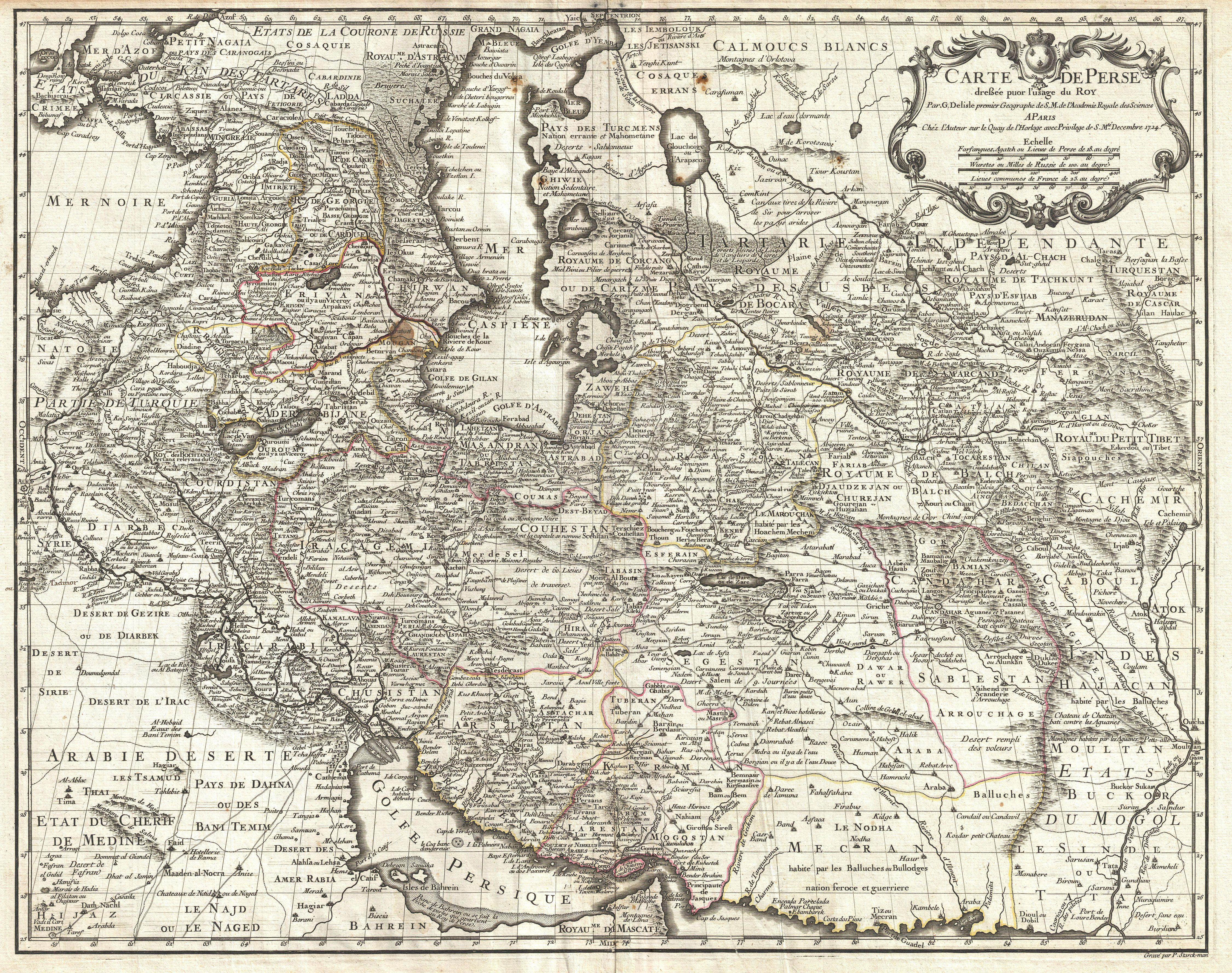
| Title | Carte de Perse, dressee pour l'usage du Roy. Par G. Delisle premier Geographe de S.M. de l'Academie Royale des Sciences. | |||||||||||||||||||||||
| Description |
English: A fine first edition example of Guillaume De L’Isle’s important 1724 map of Persia. Covers from the Crimea and the Sea of Azov south to the Persian Gulf and the Straight of Ormuz and east as far as Kashmir (Cachmir) and Kabul (Caboul). This map includes modern day Iran, Iraq, Afghanistan, Kuwait, Uzbekistan, Turkmenistan, Tajikistan, Georgia, Armenia, and Azerbaijan, with adjacent parts of Russia, Pakistan, Turkey, Ukraine, and Kazakhstan, and Arabia. Cartographically De L’Isle’s mapping of Persia marks a significant advance in European cartographic knowledge of the region. This map benefits considerably from Russian cartographic surveys and other sources no doubt smuggled to Guillaume De L’Isle by his brother Nicholas de L’Isle, who held a cartographic position with the Russian Academy of Sciences. The extent to which Russian data influenced this map is nowhere more evident than in De L’Isle’s remarkable rendering of the Caspian Sea – one of the first accurate maps of the great lake to follow Van Verden’s historic survey of 1721. Russian cartographic information is also apparent with regard to place names, such as the Russian name for the Aral Sea (Glouchoiye). It is equally likely that De L’Isle drew on Russian sources for his mapping of the Silk Route centers of Bukhara, Samarkand, and Ferghana, which were known stopping points for Russian trade envoys to China. For the remainder of Persia De L’Isle most likely updated Persian and Arabic cartographic information with reports from Georgian and Armenian traders and mercenaries active throughout Persia. It may be through these sources that De L’Isle was able to add considerable geographic information regarding trade routes and place names in central Persia. These include such significant advances as the identification of Terheran (Tiheran), the current capital of Iran, which is notable absent it earlier European maps of Persia. This map was drawn by Guillaume De L’Isle and engraved by P. Starckman. It issued independently as well as included in a number of composite atlases including De L’Isle’s 1731 Atlas de Geographie . A number of reissues by Buache, Covens & Mortier, and others followed.
|
|||||||||||||||||||||||
| Date | (undated) | |||||||||||||||||||||||
| Dimensions | Height: 20 in (50.8 cm). Width: 25 in (63.5 cm). | |||||||||||||||||||||||
| Accession number | Geographicus code: Persia-delisle-1724 | |||||||||||||||||||||||
| Source/Photographer |
De L'Isle, G., Atlas de Geographie, c. 1730.
|
|||||||||||||||||||||||
| Permission (Reusing this file) |
|
|||||||||||||||||||||||
| Other versions |
|
|||||||||||||||||||||||

_-_Geographicus_-_Persia-delisle-1724._A.jpg)
_-_Geographicus_-_Persia-delisle-1724._B.jpg)
_-_Geographicus_-_Persia-delisle-1724._C.jpg)
_-_Geographicus_-_Persia-delisle-1724._D.jpg)
_-_Geographicus_-_Persia-delisle-1724._E.jpg)
_-_Geographicus_-_Persia-delisle-1724._F.jpg)
_-_Geographicus_-_Persia-delisle-1724._G.jpg)
_-_Geographicus_-_Persia-delisle-1724._H.jpg)
_-_Geographicus_-_Persia-delisle-1724._I.jpg)
|
_-_Geographicus_-_Persia-delisle-1724.jpg)
Public Domain
| EXIF data: | |
| File name | 1724_de_l_isle_map_of_persia__iran__iraq__afghanistan__-_geographicus_-_persia-delisle-1724.jpg |
|---|---|
| Size, Mbytes | 5.7185263671875 |
| Mime type | image/jpeg |
While the copyright and licensing information supplied for each photo is believed to be accurate, Free-Photos.biz does not provide any warranty regarding the copyright status or correctness of licensing terms. If you decide to reuse the images from Free-Photos.biz, you should verify the copyright status of each image just as you would when obtaining images from other sources.
The use of depictions of living or deceased persons may be restricted in some jurisdictions by laws regarding personality rights. Such images are exhibited at Free-Photos.biz as works of art that serve higher artistic interests.
PRIVACY POLICY
By registering your account and/or by subscribing to new and newly rated photographs you agree we may send you the links to photos and we may occasionally share other information with you.
We do NOT disclose your personal data.
