Завантаження...

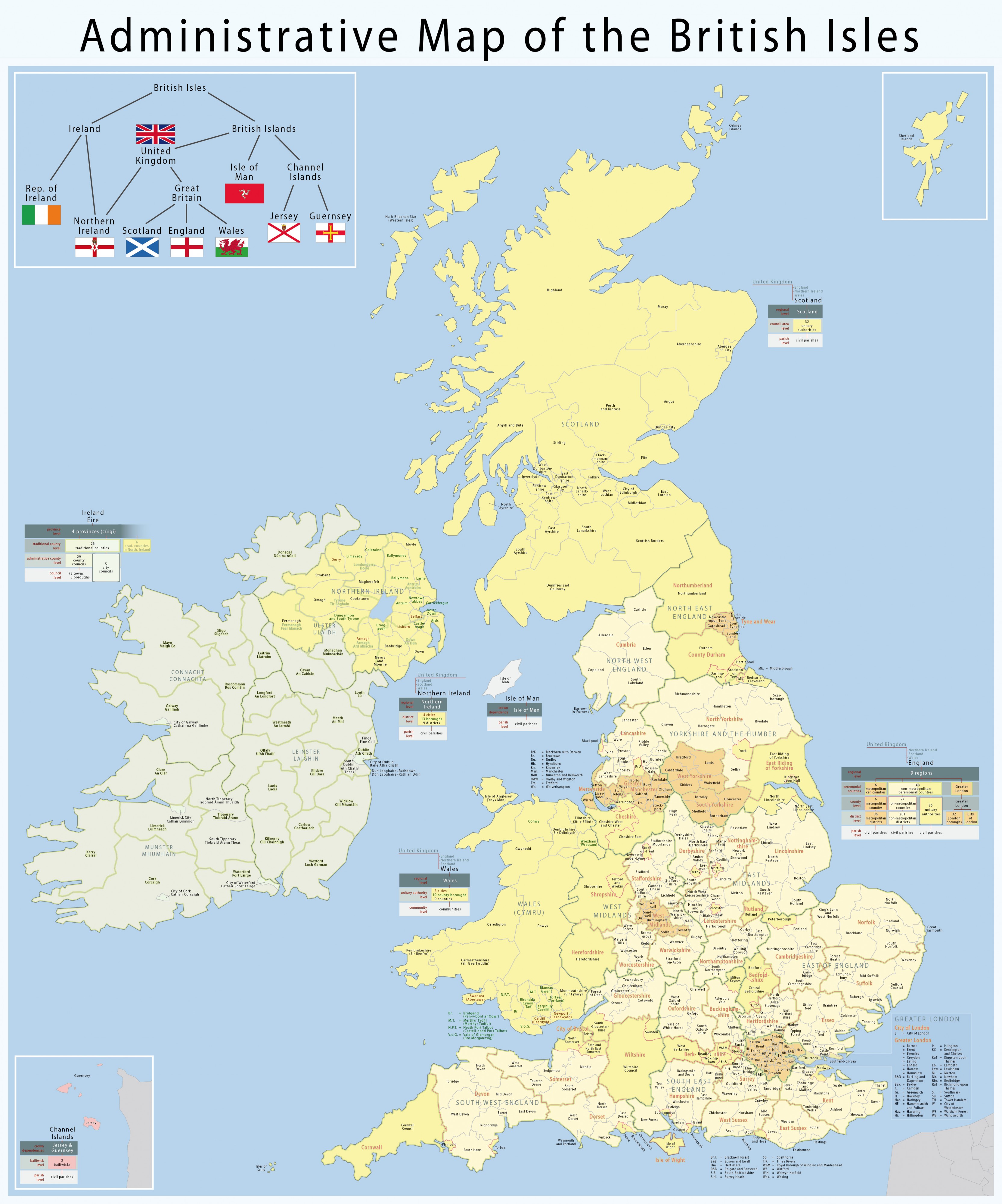
Map of the administrative geography of the British Isles


This is a premium free photo


This photo was viewed 1 times and was downloaded in full size 0 times.

This photo was liked 0 times


Source page:

http://commons.wikimedia.org/wiki/File:Map_of_the_administrative_geography_of_the_British_Isles.jpg

Summaryedit

Description
  • Deutsch: Karte der Verwaltungsgliederung des Britischen Inseln
  • English: Map of the administrative geography of the British Isles
  • Français : Plan administrative des Îles Britanniques
Date
Source Own work, using this diagram and the following flags: United Kingdom, Ireland, Northern Ireland, Scotland, England, Wales, Isle of Man, Jersey, Guernsey
Author Maximilian Dörrbecker (Chumwa)
Permission
(Reusing this file)
Flag of Germany.svg

Diese Datei habe ich als Urheber Maximilian Dörrbecker (Chumwa) unter der CC-BY-SA-3.0 (de) in der Wikipedia veröffentlicht. Dies bedeutet, dass eine kostenlose, auch kommerzielle Nutzung außerhalb der Wikipedia unter folgenden Bedingungen möglich ist:

  • Online-Medien:
    1. Als Urheber wird „Maximilian Dörrbecker/Wikipedia“ genannt.
    2. Es wird ein Link auf die Originaldatei gesetzt: //commons.wikimedia.org/wiki/File:Map_of_the_administrative_geography_of_the_British_Isles.jpg
    3. Eine Kopie des Lizenzvertrags auf Ihrer Seite oder die vollständige Internetadresse (https://creativecommons.org/licenses/by-sa/3.0/de/legalcode) zum Lizenzvertrag am Bild
  • Print-Medien:
    1. Als Urheber wird „Maximilian Dörrbecker/Wikipedia“ genannt.
    2. Eine Kopie des Lizenzvertrags oder die vollständige Internetadresse (https://creativecommons.org/licenses/by-sa/3.0/de/legalcode) zum Lizenzvertrag im Abbildungsverzeichnis des gedruckten Werks. In Bildunterschriften reicht der Hinweis „Lizenz: cc-by-sa-3.0“ auf den zugrundeliegenden Lizenzvertrag aus.

Ich bitte um Zusendung eines Belegexemplares bzw. der URL, unter der die Datei benutzt wird.

Bitte schreiben Sie mir eine E-Mail, wenn Sie

  • meine Adresse für die Zusendung eines Belegexemplares benötigen,
  • weitergehende Fragen zur Lizenznutzung haben.
Flag of the United Kingdom.svg

I have published this file as author Maximilian Dörrbecker (Chumwa) under the "CC-BY-SA-3.0" in Wikipedia. This means that free, commercial usage outside of Wikipedia is permitted under the following licence terms:

  • Online media:
    1. The author "Maximilian Dörrbecker/Wikipedia" is named.
    2. A weblink to the original file is provided: //commons.wikimedia.org/wiki/File:Map_of_the_administrative_geography_of_the_British_Isles.jpg
    3. A copy of or the Uniform Resource Identifier (https://creativecommons.org/licenses/by-sa/3.0/de/legalcode) for this licence with every copy
  • Print media:
    1. The author "Maximilian Dörrbecker/Wikipedia" is named.
    2. A copy of or the Uniform Resource Identifier (https://creativecommons.org/licenses/by-sa/3.0/de/legalcode) for this licence in the table of figures of the printed work. In image captions the reference „Licence: cc-by-sa-3.0“ for the underlying licence is sufficient.

Please send me a specimen copy or the URL of the website where the file is used.

Please write an email if you

  • need my postal address for sending a specimen copy
  • have further questions about the terms of the licence
w:en:Creative Commons
attribution share alike
This file is licensed under the Creative Commons Attribution-Share Alike 3.0 Unported license.
You are free:
  • to share – to copy, distribute and transmit the work
  • to remix – to adapt the work
Under the following conditions:
  • attribution – You must attribute the work in the manner specified by the author or licensor (but not in any way that suggests that they endorse you or your use of the work).
  • share alike – If you alter, transform, or build upon this work, you may distribute the resulting work only under the same or similar license to this one.

Other versions
Photo's description:
Karte der Verwaltungsgliederung des Britischen Inseln Map of the administrative geography of the British Isles Français : Plan administrative des Îles Britanniques


Only registered users can post comments. Please login.


EXIF data:
File name map_of_the_administrative_geography_of_the_british_isles.jpg
Size, Mbytes 3.522837890625
Mime type image/jpeg


The images at Free-Photos.biz come mainly from Wikimedia Commons or from our own production. The photos are either in the public domain, or licensed under free linceses: Free-Photos.biz license, GPL, Creative Commons or Free-Art license. Some very few other photos where uploaded to Free-Photos.biz by our users and released into the public domain or into free usage under another free license (like GPL etc.)

While the copyright and licensing information supplied for each photo is believed to be accurate, Free-Photos.biz does not provide any warranty regarding the copyright status or correctness of licensing terms. If you decide to reuse the images from Free-Photos.biz, you should verify the copyright status of each image just as you would when obtaining images from other sources.


The use of depictions of living or deceased persons may be restricted in some jurisdictions by laws regarding personality rights. Such images are exhibited at Free-Photos.biz as works of art that serve higher artistic interests.

PRIVACY POLICY


By registering your account and/or by subscribing to new and newly rated photographs you agree we may send you the links to photos and we may occasionally share other information with you.

We do NOT disclose your personal data.


christianity portal