

Please login in order to download photos in full size
If you are not registered, please register for free: www.Free-Photos.biz/register
Please note to download premium images you also need to join as a free member..
You can also save the photos without the registration - but only in small and average sizes, and some of them will have the site's watermark. Please simply click your right mouse button and save the image.
Please login in order to like photos
If you are not registered, please register for free:
Sorry, non-members can download up to 1100 full-size photos per month.
It looks like you have used up your limit.
Free members can download an unlimited number of full-size photos - including the premium free photos.
Join as a member today for FREE! - and download the images without limitations:
www.Free-Photos.biz/membership.php
You can also save the images without the membership - but only in small and average sizes, and some of them may have the site's watermark. Please simply click your right mouse button and save the image.
|
This is a premium free photo
This photo was viewed 2 times and was downloaded in full size 1 times.
This photo was liked 0 times


If you are a member, please login in order to see the source link of the above image.
Summary
| Description |
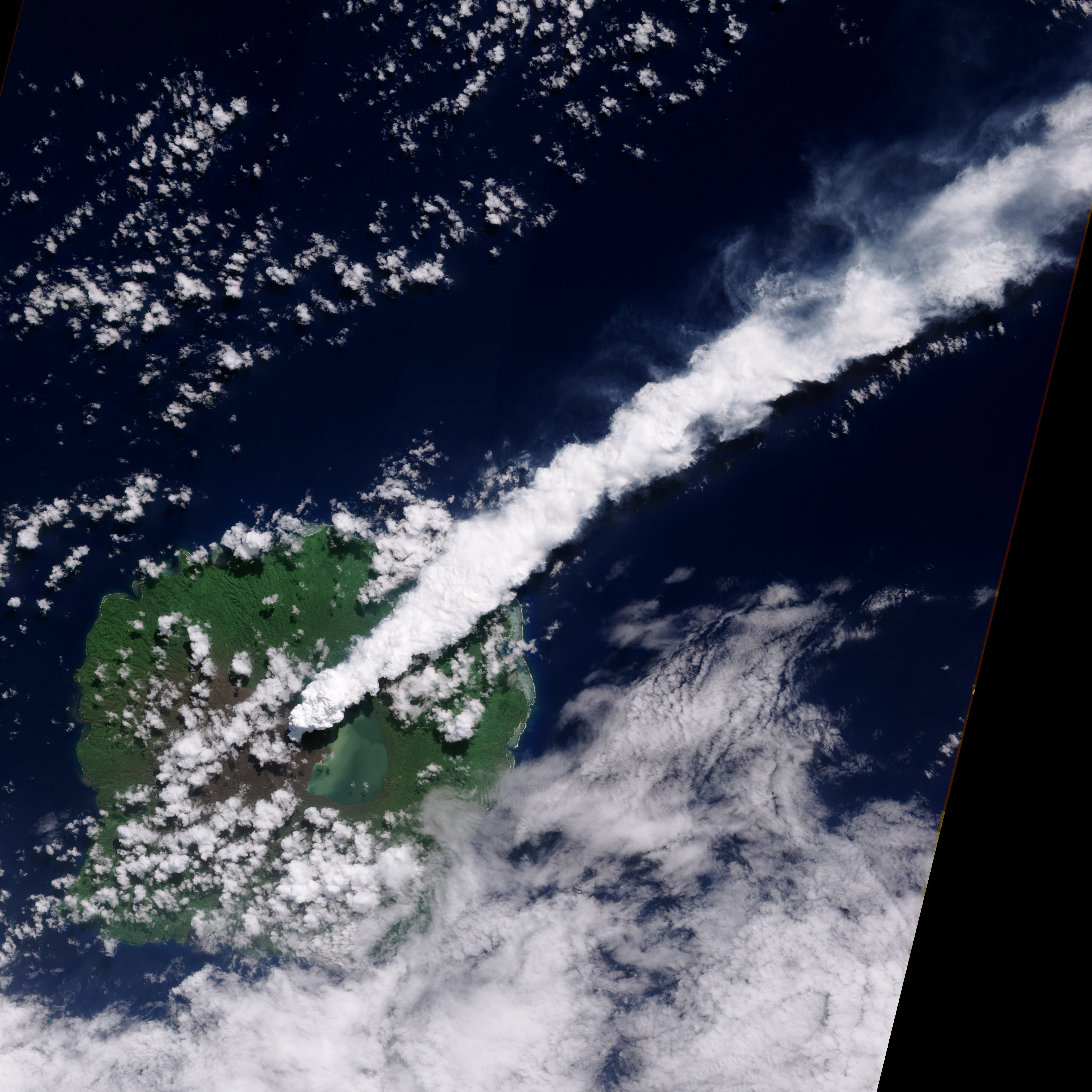
English: In early April 2010, activity at Gaua Volcano in the Vanuatu Archipelago increased. The Vanuatu Geohazards Observatory reported that the ash column, which first appeared in October 2009, became thicker and higher, and volcanic bombs were frequently sighted from the coastal villages surrounding the volcano. According to Radio New Zealand International, Vanuatu government officials are preparing to evacuate residents of Gaua Island, who are threatened by ash, poisonous gases, and landslides. The thick, steam-rich plume from Guau Volcano blows directly northeast in this natural-color satellite image. It was acquired on April 24, 2010 by the Advanced Land Imager aboard NASA’s Earth Observing-1 (EO-1) spacecraft. The thick steam is brighter white than the surrounding lower-altitude clouds. Vegetation is green, as is Lake Letas. Vegetation to the south and west of the volcano, damaged by ash and acidic volcanic gases, is dark gray-brown.
|
| Date | 24 April 2010 |
| Source | https://earthobservatory.nasa.gov/NaturalHazards/view.php?id=43789&src=nha |
| Author | NASA image by Jesse Allen & Robert Simmon, using ALI data from the EO-1 team. Caption by Robert Simmon |
| Other versions |
|

Licensing
| This file is in the public domain because it was created by NASA. NASA copyright policy states that "NASA material is not protected by copyright unless noted". (See Template:PD-USGov, NASA copyright policy page or JPL Image Use Policy.)
|
|
|
|
Warnings:
|
Public Domain
| EXIF data: | |
| File name | eruption_of_gaua_volcano_2010-04-24_lrg.jpg |
|---|---|
| Size, Mbytes | 2.3917548828125 |
| Mime type | image/jpeg |
| Orientation of image | 1 |
| Image resolution in width direction | 1 |
| Image resolution in height direction | 1 |
| Unit of X and Y resolution | 2 |
| Color space information | 1 |
| Exif image width | 4872 |
| Exif image length | 4872 |
| Software used | Adobe Photoshop CS4 Windows |
While the copyright and licensing information supplied for each photo is believed to be accurate, Free-Photos.biz does not provide any warranty regarding the copyright status or correctness of licensing terms. If you decide to reuse the images from Free-Photos.biz, you should verify the copyright status of each image just as you would when obtaining images from other sources.
The use of depictions of living or deceased persons may be restricted in some jurisdictions by laws regarding personality rights. Such images are exhibited at Free-Photos.biz as works of art that serve higher artistic interests.
PRIVACY POLICY
By registering your account and/or by subscribing to new and newly rated photographs you agree we may send you the links to photos and we may occasionally share other information with you.
We do NOT disclose your personal data.
