

Please login in order to download photos in full size
If you are not registered, please register for free: www.Free-Photos.biz/register
Please note to download premium images you also need to join as a free member..
You can also save the photos without the registration - but only in small and average sizes, and some of them will have the site's watermark. Please simply click your right mouse button and save the image.
Please login in order to like photos
If you are not registered, please register for free:
Sorry, non-members can download up to 1100 full-size photos per month.
It looks like you have used up your limit.
Free members can download an unlimited number of full-size photos - including the premium free photos.
Join as a member today for FREE! - and download the images without limitations:
www.Free-Photos.biz/membership.php
You can also save the images without the membership - but only in small and average sizes, and some of them may have the site's watermark. Please simply click your right mouse button and save the image.
|
This is a premium free photo
This photo was viewed 2 times and was downloaded in full size 0 times.
This photo was liked 0 times


If you are a member, please login in order to see the source link of the above image.
| Artist | https://www.geographicus.com/mm5/cartographers/deveer.txt | |||||
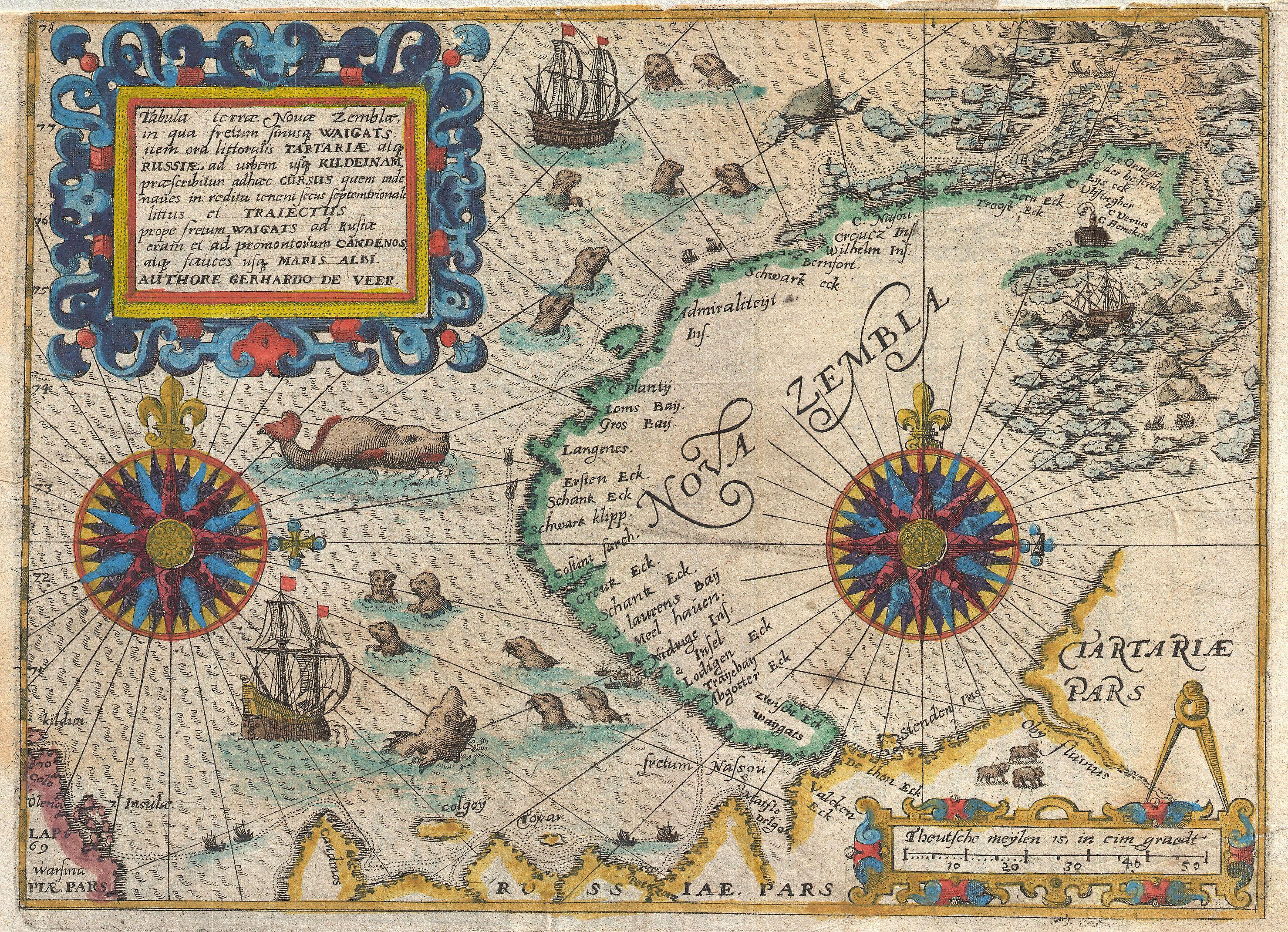
| Title | Tabula terrae Nouae Zemblae in qua fretum sinusq Waigats item ord littorialis Tartariae atq Russiae, ad urgem usq Kildeinam ….Authore Gerhardo De Veer. | |||||
| Description |
English: A highly important map regarding the early search for a Northeast Passage. This remarkable map was drawn in 1601 by Theodore de Bry to describe the ill fated third voyage of the Dutch explorer William Barentsz in search of the Northeast Passage. The map depicts the Island of Nova Zemba, or Novaya Zemlya, in the Russian Arctic along with two stunning compass roses, numerous rhumb lines, and a multitude of seals and sea monsters. Throughout the 16th and 17th centuries the concept of a Northeast Passage through the Arctic to Asia held the same significance as North America's Northwest Passage. The nations of Northern Europe, particularly Russia and Holland, were eager to find an easy route to Asia via the Arctic in order to access the lucrative trade with China and India. Barentsz's first expedition in 1594, in which he discovered Novaya Zemlya and a number of other Arctic Islands, was widely publicized in Europe and led to the assumption that a Northwest Passage may indeed be feasible. His second voyage, 1595, was considered a truncated failure due to inclement weather and ice packs in the Kara Sea. A year later, his third voyage in 1596 was a utter disaster. Our map details Barentsz's route as he passes north of Finland and thus into the Russian Arctic. His expedition then travels north and northwest along the western shore and ultimately around the northern tip of the archipelago. Here the ice flows coming out of the high Arctic trapped Barentsz 'sexpedition and ultimately forced them ashore. Using the timber from their ship they constructed a small cabin where, subsisting on stores from the ship and the occasional polar bear, they survived the unbelievably harsh winter. By June, the ice still refused to yield up the surviving ship, so the desperate sailors decided to try their luck on two smaller vessels. These, shown at the extreme right of the map, in seven weeks of harrowing sea travel eventually circumnavigated Nova Zembla and were rescued by a Russian merchant vessel near the Kola Peninsula. Barentsz himself perished on this desperate trip scarcely seven days after leaving Nova Zembla. However, some of his companions, on returning Holland, published an account of the voyage for which this map was made. In 1871, the Norwegian seal hunter Elling Carlsen rediscovered Barentsz' cabin on Nova Zembla - perfectly preserved due to the Arctic cold. Today icebreakers filled with tourists stop at the site as they round Nova Zembla. On a darker note, Nova Zembla, or more appropriately in this case Novaya Zemlya, was also the site of Russian nuclear testing during the Cold War. The world's largest above ground nuclear detonation, the 50 megaton Tsar Bomba, exploded here n 1961. Drawn by Gerhardo de Veer, a survivor of all three of Barentsz's expeditons, and published c. 1601 by Theodore de Bry in the third issue of the first Latin edition of Grands et Petits Voyages .
|
|||||
| Date | (undated) | |||||
| Dimensions | Height: 7 in (17.8 cm). Width: 9.5 in (24.1 cm). | |||||
| Accession number | Geographicus link: NovaZembla-debry-1601 | |||||
| Source/Photographer |
De Bry, Theodore, Grands and Petits Voyages (First Latin Edition, Third Issue), 1590 - 1634.
|
|||||
| Permission (Reusing this file) |
|
|||||
Public Domain
| EXIF data: | |
| File name | 1601_de_bry_and_de_veer_map_of_nova_zembla_and_the_northeast_passage_-_geographicus_-_novazembla-debry-1601.jpg |
|---|---|
| Size, Mbytes | 2.7458896484375 |
| Mime type | image/jpeg |
While the copyright and licensing information supplied for each photo is believed to be accurate, Free-Photos.biz does not provide any warranty regarding the copyright status or correctness of licensing terms. If you decide to reuse the images from Free-Photos.biz, you should verify the copyright status of each image just as you would when obtaining images from other sources.
The use of depictions of living or deceased persons may be restricted in some jurisdictions by laws regarding personality rights. Such images are exhibited at Free-Photos.biz as works of art that serve higher artistic interests.
PRIVACY POLICY
By registering your account and/or by subscribing to new and newly rated photographs you agree we may send you the links to photos and we may occasionally share other information with you.
We do NOT disclose your personal data.
