

Please login in order to download photos in full size
If you are not registered, please register for free: www.Free-Photos.biz/register
Please note to download premium images you also need to join as a free member..
You can also save the photos without the registration - but only in small and average sizes, and some of them will have the site's watermark. Please simply click your right mouse button and save the image.
Please login in order to like photos
If you are not registered, please register for free:
Sorry, non-members can download up to 1100 full-size photos per month.
It looks like you have used up your limit.
Free members can download an unlimited number of full-size photos - including the premium free photos.
Join as a member today for FREE! - and download the images without limitations:
www.Free-Photos.biz/membership.php
You can also save the images without the membership - but only in small and average sizes, and some of them may have the site's watermark. Please simply click your right mouse button and save the image.
|
This is a premium free photo
This photo was viewed 5 times and was downloaded in full size 1 times.
This photo was liked 0 times


If you are a member, please login in order to see the source link of the above image.
| Artist |
|
|||||||||||||||||||||||
| Title |
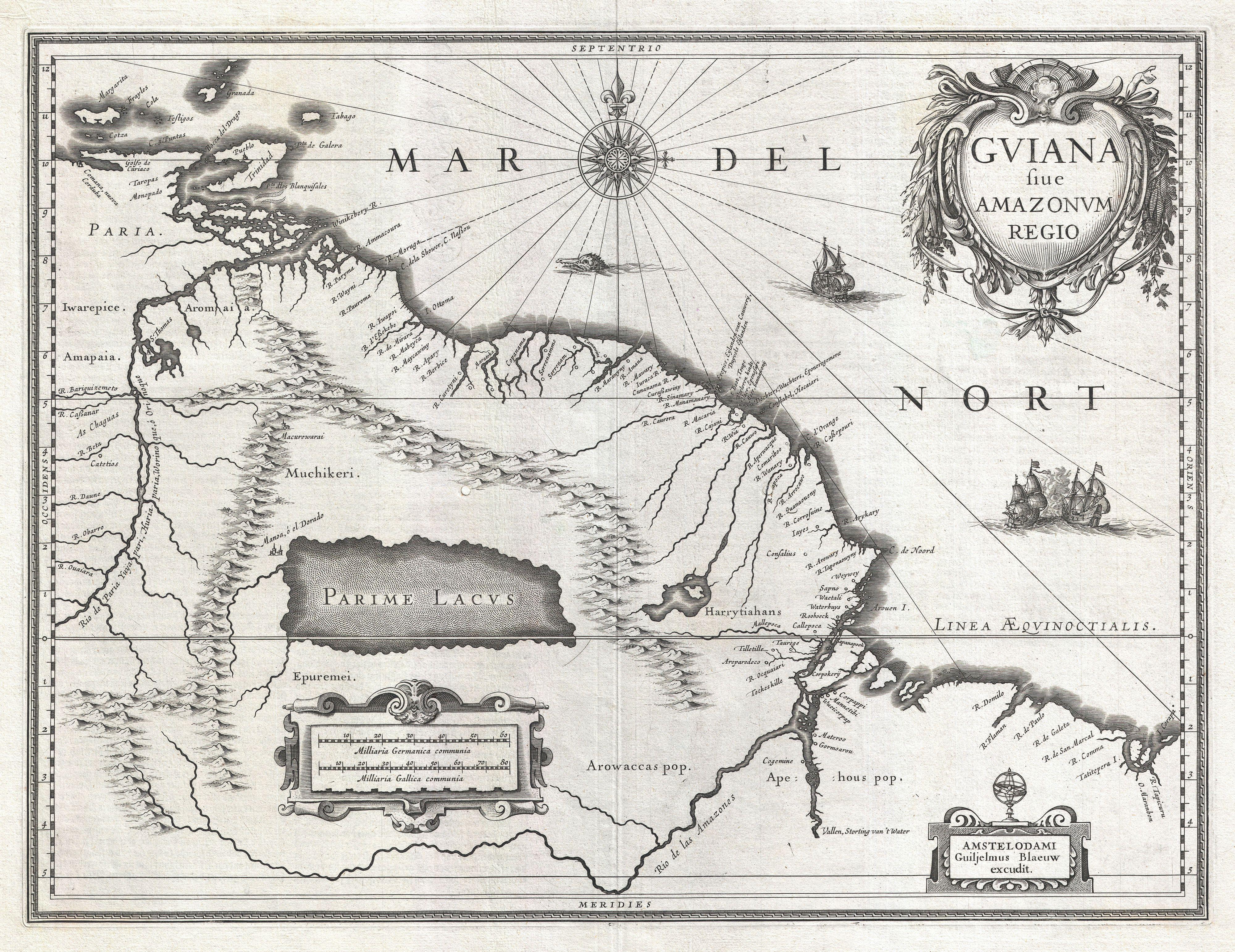
Latina: Gviana siue Amazonvm Regio.
|
|||||||||||||||||||||||
| Description |
English: This is G. Blaeu's remarkable c. 1635 map of the northwestern parts of South America , Lake Parima (Parime Lacus), and the route to El Dorado. Blaeu initially issued this map in 1630 and variants were published well in to the 1660s. This example dates to the 1635 German edition of Blaeu's atlas. The map covers from Isla Margarita and the Orinoco Delta eastward as far as Tampico and southwards as far as the Amazon River. This region of South America generated considerable European interest in the early 17th century following the publication of Sir Walter Raleigh's fascinating Discovery of the Large, Rich, and Beautiful EMPIRE Of GUIANA . Raleigh's expedition traveled down the Orinoco River in search of the Kingdom of El Dorado. Today we know that El Dorado did not exist, but was rather an amalgam of very real tribal traditions and the European lust for gold. Nonetheless, in the 16th century, tales of El Dorado were common conversation along the port cities of the Spanish Main. Having explored a considerable distance down the Orinoco, Raleigh's expedition found itself mired in a remote tribal village at the onset of the rainy season. While waiting for an opportunity to return north, a trading delegation arrived. At this time the dominate trading empire in the Amazon were the Manoa, who, though based near modern day Manaus, pursued trade routes to from the foothills of the Andes to the Amazon and Orinoco Deltas. While the rainy season prevented Raleigh from moving forward, for the Manoa it had the opposite effect. The heavy rains inundated the vast Parima flood plain creating a great inland sea, consequently opening an important trade connection between the Amazon and Orinoco Rivers. When the Manoa arrived, Raleigh and his men noticed that they had various golden trinkets for sale. This was apparently enough for Raleigh to deduce that they must indeed be from the hidden kingdom of El Dorado. When Raleigh asked where the traders came from, the locals, with no common language with which to engage Raleigh, could only explain that they traveled across a great water and were from Manoa. Raleigh's presumptuous narrative inspired many early cartographers to map this massive lake, with the city of El Dorado or Manoa on its shores, in the unexplored lands between the Orinoco and Amazon River basins. In addition to Blaeu's fascinating depiction of Lake Parima, among the most prominent such in any mapping of this region, there are also a number of attractive decorative elements. Three sailing ships ply the waters and just under the compass rose a scary looking sea monster swims toward shore. A decorative baroque title cartouche appears in the upper right quadrant and, at the bottom of the map, to small cartouches frame a distance scales and Blaeu's signature. Uncolored as issued.
|
|||||||||||||||||||||||
| Date | 1635 (undated) | |||||||||||||||||||||||
| Dimensions | Height: 15 in (38.1 cm). Width: 20 in (50.8 cm). | |||||||||||||||||||||||
| Accession number | Geographicus code: Guiana-blaeu-1635 | |||||||||||||||||||||||
| Source/Photographer |
Blaeu, G., Atlantis Appendix, sive pars altera, continens tab. geographicas diversarum Orbis regionum, 1630.
|
|||||||||||||||||||||||
| Permission (Reusing this file) |
|
|||||||||||||||||||||||

Public Domain
| EXIF data: | |
| File name | 1635_blaeu_map_guiana__venezuela__and_el_dorado_-_geographicus_-_guiana-blaeu-1635.jpg |
|---|---|
| Size, Mbytes | 3.596927734375 |
| Mime type | image/jpeg |
While the copyright and licensing information supplied for each photo is believed to be accurate, Free-Photos.biz does not provide any warranty regarding the copyright status or correctness of licensing terms. If you decide to reuse the images from Free-Photos.biz, you should verify the copyright status of each image just as you would when obtaining images from other sources.
The use of depictions of living or deceased persons may be restricted in some jurisdictions by laws regarding personality rights. Such images are exhibited at Free-Photos.biz as works of art that serve higher artistic interests.
PRIVACY POLICY
By registering your account and/or by subscribing to new and newly rated photographs you agree we may send you the links to photos and we may occasionally share other information with you.
We do NOT disclose your personal data.
