

Please login in order to download photos in full size
If you are not registered, please register for free: www.Free-Photos.biz/register
Please note to download premium images you also need to join as a free member..
You can also save the photos without the registration - but only in small and average sizes, and some of them will have the site's watermark. Please simply click your right mouse button and save the image.
Please login in order to like photos
If you are not registered, please register for free:
Sorry, non-members can download up to 1100 full-size photos per month.
It looks like you have used up your limit.
Free members can download an unlimited number of full-size photos - including the premium free photos.
Join as a member today for FREE! - and download the images without limitations:
www.Free-Photos.biz/membership.php
You can also save the images without the membership - but only in small and average sizes, and some of them may have the site's watermark. Please simply click your right mouse button and save the image.
|
This is a premium free photo
This photo was viewed 2 times and was downloaded in full size 0 times.
This photo was liked 0 times


If you are a member, please login in order to see the source link of the above image.
| Artist | Unknown | ||||
| Title |
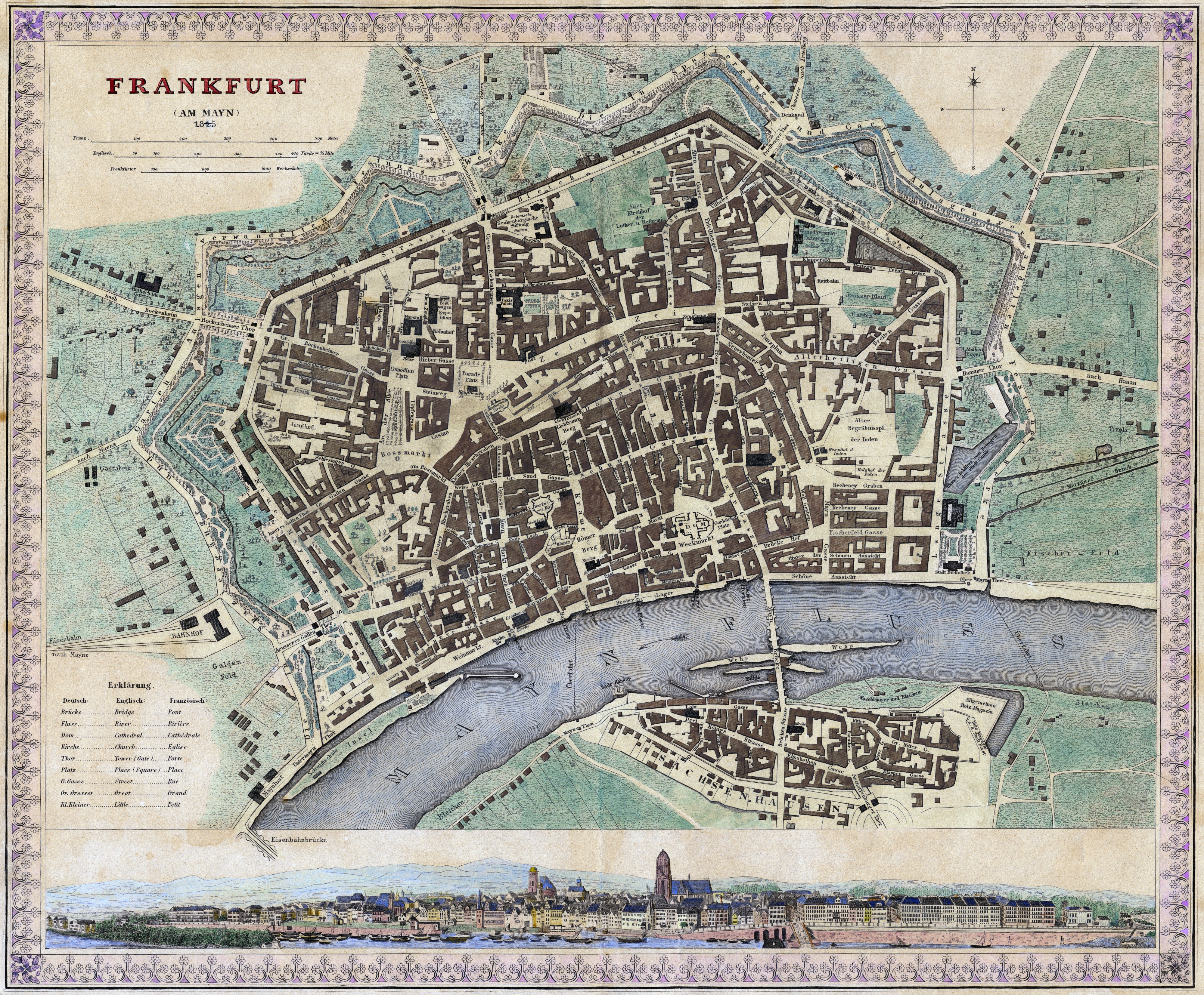
Deutsch: Frankfurt (Am Mayn) 1845.
|
||||
| Date | 1837 / 1845 | ||||
| Medium | hand-colored steel engraving | ||||
| Dimensions | 36 × 30 cm (14.2 × 11.8 in) | ||||
| Current location | Private collection Mylius | ||||
| Frankfurt am Main | |||||
| Notes |
English: Although published in 1845 the map is just a slightly revised and therefore partly yet obsolete version of an 1837 plan by the Society for the Diffusion of Useful Knowledge.
Deutsch: Obwohl 1845 veröffentlicht handelt es sich bei der Karte nur um eine geringfügig und somit bereits damals in Teilen wieder überholte Version eines Planes der Society for the Diffusion of Useful Knowledge von 1837.
|
||||
| Source/Photographer | Frankfurt (Am Mayn) 1845. Meyer's Handatlas No. 62. In: Joseph Meyer (Hrsg.): Grosser Hand-Atlas über alle Theile der Erde in 170 Karten. Verlag des Bibliographischen Instituts, Hildburghausen 1843–60. | ||||
| Permission (Reusing this file) |
|
||||
|
This image has been assessed using the Quality image guidelines and is considered a Quality image. |
This image (or other media file) is in the public domain because its copyright has expired. This applies to Australia, the European Union and those countries with a copyright term of life of the author plus 70 years. You must also include a United States public domain tag to indicate why this work is in the public domain in the United States. Note that a few countries have copyright terms longer than 70 years: Mexico has 100 years, Colombia has 80 years, and Guatemala and Samoa have 75 years, Russia has 74 years for some authors. This image may not be in the public domain in these countries, which moreover do not implement the rule of the shorter term. Côte d'Ivoire has a general copyright term of 99 years and Honduras has 75 years, but they do implement the rule of the shorter term. This file has been identified as being free of known restrictions under copyright law, including all related and neighboring rights. Quality image This image has been assessed using the Quality image guidelines and is considered a Quality image. العربية | беларуская (тарашкевіца) | български | català | čeština | Deutsch | Zazaki | Ελληνικά | English | Esperanto | español | eesti | فارسی | suomi | français | galego | हिन्दी | hrvatski | magyar | Հայերեն | italiano | 日本語 | ქართული | 한국어 | Kurdî | lietuvių | македонски | മലയാളം | Bahasa Melayu | Nederlands | polski | português | português do Brasil | română | русский | slovenčina | slovenščina | српски / srpski | svenska | தமிழ் | తెలుగు | ไทย | Türkçe | українська | vèneto | Tiếng Việt | 中文 | 中文(简体) | 中文(繁體) | +/− File history Click on a date/tim
Public Domain
| EXIF data: | |
| File name | frankfurt_am_main-freie_stadt_frankfurt-plan-1845.jpg |
|---|---|
| Size, Mbytes | 42.496625976562 |
| Mime type | image/jpeg |
| Orientation of image | 1 |
| Image resolution in width direction | 72 |
| Image resolution in height direction | 72 |
| Unit of X and Y resolution | 2 |
| Color space information | 65535 |
| Exif image width | 7000 |
| Exif image length | 5789 |
| Software used | Adobe Photoshop CS3 Windows |
While the copyright and licensing information supplied for each photo is believed to be accurate, Free-Photos.biz does not provide any warranty regarding the copyright status or correctness of licensing terms. If you decide to reuse the images from Free-Photos.biz, you should verify the copyright status of each image just as you would when obtaining images from other sources.
The use of depictions of living or deceased persons may be restricted in some jurisdictions by laws regarding personality rights. Such images are exhibited at Free-Photos.biz as works of art that serve higher artistic interests.
PRIVACY POLICY
By registering your account and/or by subscribing to new and newly rated photographs you agree we may send you the links to photos and we may occasionally share other information with you.
We do NOT disclose your personal data.
