

Please login in order to download photos in full size
If you are not registered, please register for free: www.Free-Photos.biz/register
Please note to download premium images you also need to join as a free member..
You can also save the photos without the registration - but only in small and average sizes, and some of them will have the site's watermark. Please simply click your right mouse button and save the image.
Please login in order to like photos
If you are not registered, please register for free:
Sorry, non-members can download up to 1100 full-size photos per month.
It looks like you have used up your limit.
Free members can download an unlimited number of full-size photos - including the premium free photos.
Join as a member today for FREE! - and download the images without limitations:
www.Free-Photos.biz/membership.php
You can also save the images without the membership - but only in small and average sizes, and some of them may have the site's watermark. Please simply click your right mouse button and save the image.
|
This is a premium free photo
This photo was viewed 4 times and was downloaded in full size 1 times.
This photo was liked 0 times


If you are a member, please login in order to see the source link of the above image.
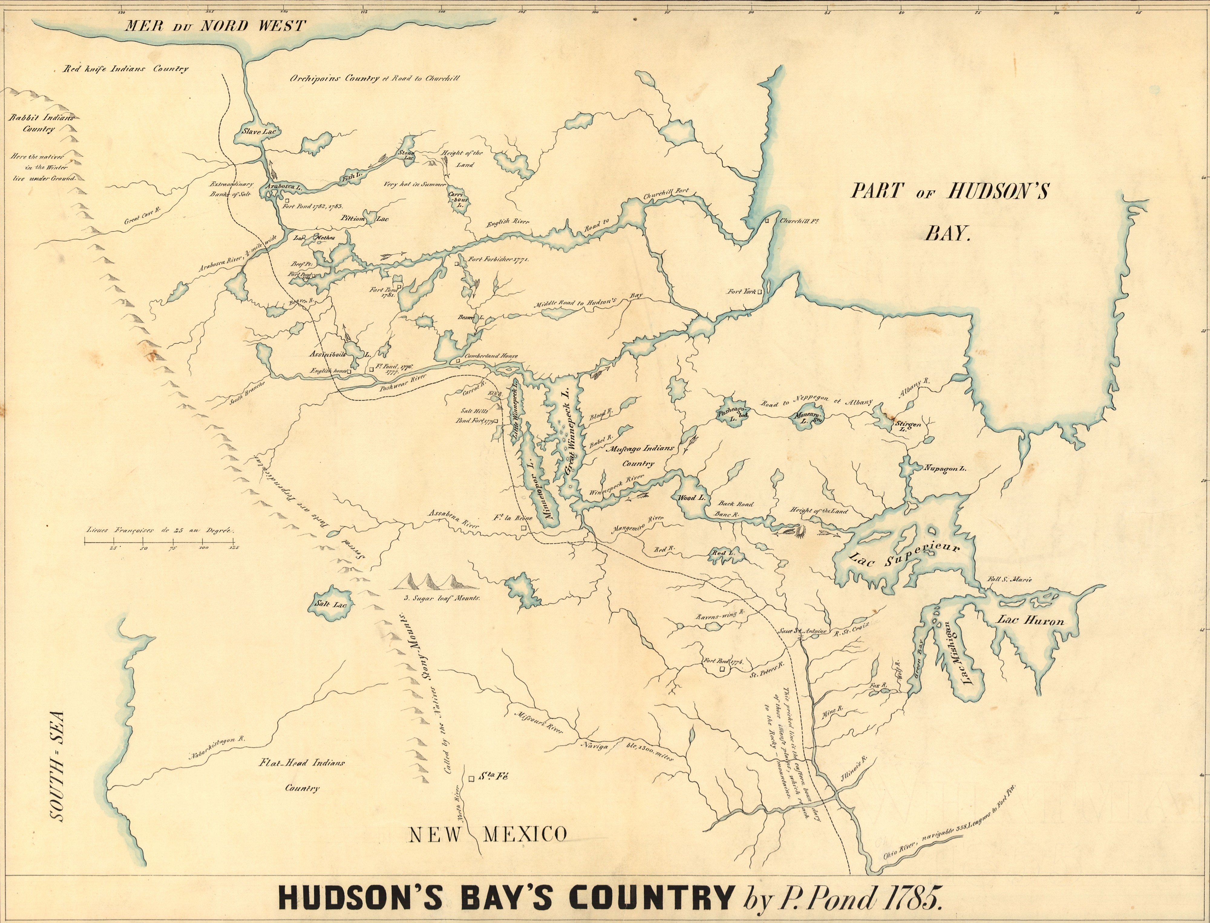
| Description | The following is the author's description of the photograph quoted directly from the photograph's Flickr page. "The immense territory to the northwest of the Methye Portage at the watershed between the Churchill and the Athabaska basins was virtually unknown at the date of this map. Very few traders were working in the Mackenzie Basin, but Peter Pond was the most experienced and had been the first across the Portage. Judging from the evidence available he had not been beyond Lake Athabaska by 1784, but from Indian reports he had amassed a considerable understanding of the more northerly regions. On this map he drew the Mackenzie, Churchill, Saskatchewan, Nelson, and Albany systems, the Manitoba Lakes and the Border Lakes, and showed their interconnections. No previous map, nor any in the next decade, outlines the general hydrographic pattern of western Canada as did this one. Hudson and James Bays are misproportioned, as are the Great Lakes but these are unimportant aspects, for it was the interior network which Pond was emphasizing. (Warkentin and Ruggles. Historical Atlas of Manitoba. map 42, p. 106) ------------------- Hudson's Bay's country / by P. Pond, 1785. "This is a copy of an interesting manuscript map which is preserved in the Archives of the Hudson's Bay Company in London and which has the following title: 'Copy of a map, presented to the Congress by Peter Pond, a native of Milford in the state of Connecticut ...'" Pen-and-ink and watercolor. Scale [ca. 1:7,000,000] Image Source: Library of Congress American Memory Project " |
|||||
| Date | 1785 | |||||
| Source | Library of Congress American Memory Project
|
|||||
| Author | Peter Pond | |||||
| Permission (Reusing this file) |
|

Upload history
- originally posted to Flickr as Hudson's Bay's Country (Peter Pond 1785), where it was licensed cc-by-2.0
- Uploaded using F2ComButton
| This image was originally posted to Flickr by Manitoba Historical Maps at https://flickr.com/photos/11496488@N07/2178544727. It was reviewed on 16 November 2009 by the FlickreviewR robot and confirmed to be licensed under the terms of the cc-by-2.0. |
Public Domain
| EXIF data: | |
| File name | hudson_s_bay_s_country__peter_pond_1785_.jpg |
|---|---|
| Size, Mbytes | 3.8458662109375 |
| Mime type | image/jpeg |
| Orientation of image | 1 |
| Image resolution in width direction | 72 |
| Image resolution in height direction | 72 |
| Unit of X and Y resolution | 2 |
| Color space information | 65535 |
| Exif image width | 7287 |
| Exif image length | 5560 |
| Software used | Adobe Photoshop CS2 Windows |
While the copyright and licensing information supplied for each photo is believed to be accurate, Free-Photos.biz does not provide any warranty regarding the copyright status or correctness of licensing terms. If you decide to reuse the images from Free-Photos.biz, you should verify the copyright status of each image just as you would when obtaining images from other sources.
The use of depictions of living or deceased persons may be restricted in some jurisdictions by laws regarding personality rights. Such images are exhibited at Free-Photos.biz as works of art that serve higher artistic interests.
PRIVACY POLICY
By registering your account and/or by subscribing to new and newly rated photographs you agree we may send you the links to photos and we may occasionally share other information with you.
We do NOT disclose your personal data.
