

Please login in order to download photos in full size
If you are not registered, please register for free: www.Free-Photos.biz/register
Please note to download premium images you also need to join as a free member..
You can also save the photos without the registration - but only in small and average sizes, and some of them will have the site's watermark. Please simply click your right mouse button and save the image.
Please login in order to like photos
If you are not registered, please register for free:
Sorry, non-members can download up to 1100 full-size photos per month.
It looks like you have used up your limit.
Free members can download an unlimited number of full-size photos - including the premium free photos.
Join as a member today for FREE! - and download the images without limitations:
www.Free-Photos.biz/membership.php
You can also save the images without the membership - but only in small and average sizes, and some of them may have the site's watermark. Please simply click your right mouse button and save the image.
|
This is a premium free photo
This photo was viewed 16 times and was downloaded in full size 0 times.
This photo was liked 0 times


Source page: |
http://commons.wikimedia.org/wiki/File:Bellin_map_of_the_Ionian_Sea_1797_IAN_0134.jpg |
|---|
|
Summaryedit
| Title |
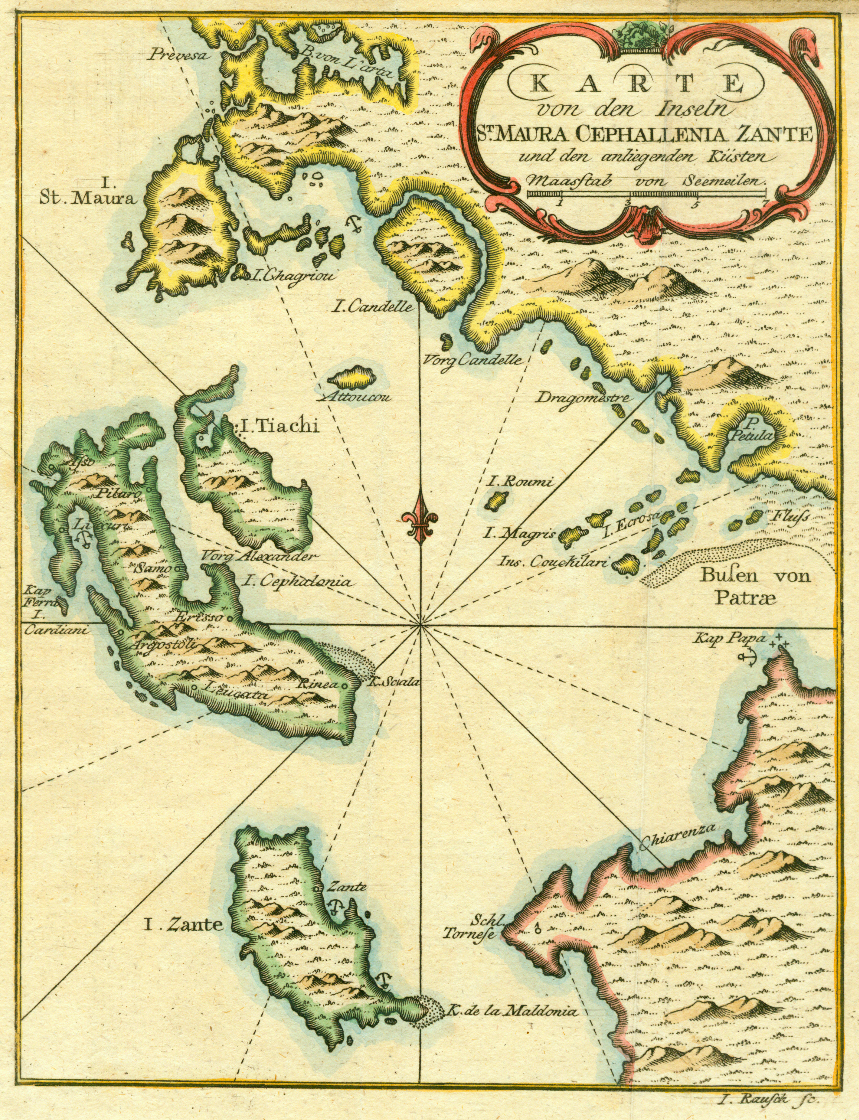
Deutsch: Karte von den Inseln St. Maura Cephallenia Zante und den anliegenden Kusten. English: Map of the islands of Lefkas, Cephalonia, Zante and the adjacent coast. Ελληνικά: Χάρτης των νήσων Λευκάδας, Κεφαλληνίας, Ζακύνθου και των παρακείμενων ακτών. |
||||||||||||||||||||
| Description |
English: Map of the island of Lefkas, Cephalonia, Zante and the coast of western Greece, drawn by Jacques Nicolas Bellin, in 1797. Copper engraving by I. Rausch, Nuremberg. Nikos D. Karabelas map collection, Actia Nicopolis Foundation, Preveza, Greece.
Ελληνικά: Χάρτης των νήσων Λευκάδος, Κεφαλονιάς και Ζακύνθου με τις γειτονικές ακτές της δυτικής Ελλάδας, σχεδιασμένος από τον Jacques Nicolas Bellin το 1797. Χαλκογραφία του I. Rausch, Νυρεμβέργη, 1797. Συλλογή χαρτών Νίκου Δ. Καράμπελα, Ίδρυμα Ακτία Νικόπολις, Πρέβεζα
|
||||||||||||||||||||
| Author |
|
||||||||||||||||||||
| Date | |||||||||||||||||||||
| Source | Unknown German edition, Nuremberg, 1797.
|
||||||||||||||||||||
| Permission (Reusing this file) |
|
||||||||||||||||||||
| Geotemporal data | |||||||||||||||||||||
| Date depicted | |||||||||||||||||||||
| Map location |
Ionian Islands and western Greece |
||||||||||||||||||||
| Map scale | maasstab von Seemeilen 7 | ||||||||||||||||||||
| Heading |
 |
||||||||||||||||||||
| Bounding box |
|
||||||||||||||||||||
| Georeferencing | If inappropriate please set warp_status=skip to hide. | ||||||||||||||||||||
| Bibliographic data | |||||||||||||||||||||
| Map set / atlas |
English: Actia Nicopolis Foundation, Preveza, Greece. Nikos D. Karabelas map collection. Ελληνικά: Ίδρυμα Ακτία Νικόπολις, Πρέβεζα. Συλλογή χαρτών Νίκου Δ. Καράμπελα. |
||||||||||||||||||||
| Map sheet | IAN 0134 | ||||||||||||||||||||
| Map type | map | ||||||||||||||||||||
| Language | german | ||||||||||||||||||||
| Year of publication | |||||||||||||||||||||
| Archival data | |||||||||||||||||||||
| Institution |
|
||||||||||||||||||||
| Accession number | IAN_0134 | ||||||||||||||||||||
| Dimensions | Height: 200 mm (7.87 ″); Width: 154 mm (6.06 ″) | ||||||||||||||||||||
| Medium |
English: Copper engraving. Ελληνικά: Χαλκογραφία. |
||||||||||||||||||||
| Inscriptions | Prevesa / B. von L' arta / I. St. Maura / I. Chagriou / I. Candelle / Attoucou / Vorg Candelle / Dragomestre / P. Petula / Fluss / I. Roumi / I. Magris / Ins. Couchilari / I. Ecrosa / Busen von Patrae / Kap Papa / Chiarenza / Schl. Tornese / K. de la Maldonia / I. Zante / K. Scala / Rinea / Leucata / Argostoli / Erisso / Kap Ferra / I. Cardiani / Samo / I. Cephalonia / Vorg Alexander / Lixuri / Pilaro / Asso / I. Tiachi / I. Rausch sc. | ||||||||||||||||||||

| EXIF data: | |
| File name | bellin_map_of_the_ionian_sea_1797_ian_0134.jpg |
|---|---|
| Size, Mbytes | 12.314872070313 |
| Mime type | image/jpeg |
| Orientation of image | 1 |
| Image resolution in width direction | 500 |
| Image resolution in height direction | 500 |
| Unit of X and Y resolution | 2 |
| Color space information | 65535 |
| Exif image width | 2977 |
| Exif image length | 3882 |
| Software used | Adobe Photoshop CS2 Windows |
While the copyright and licensing information supplied for each photo is believed to be accurate, Free-Photos.biz does not provide any warranty regarding the copyright status or correctness of licensing terms. If you decide to reuse the images from Free-Photos.biz, you should verify the copyright status of each image just as you would when obtaining images from other sources.
The use of depictions of living or deceased persons may be restricted in some jurisdictions by laws regarding personality rights. Such images are exhibited at Free-Photos.biz as works of art that serve higher artistic interests.
PRIVACY POLICY
By registering your account and/or by subscribing to new and newly rated photographs you agree we may send you the links to photos and we may occasionally share other information with you.
We do NOT disclose your personal data.
