

Please login in order to download photos in full size
If you are not registered, please register for free: www.Free-Photos.biz/register
Please note to download premium images you also need to join as a free member..
You can also save the photos without the registration - but only in small and average sizes, and some of them will have the site's watermark. Please simply click your right mouse button and save the image.
Please login in order to like photos
If you are not registered, please register for free:
Sorry, non-members can download up to 1100 full-size photos per month.
It looks like you have used up your limit.
Free members can download an unlimited number of full-size photos - including the premium free photos.
Join as a member today for FREE! - and download the images without limitations:
www.Free-Photos.biz/membership.php
You can also save the images without the membership - but only in small and average sizes, and some of them may have the site's watermark. Please simply click your right mouse button and save the image.
|
This is a premium free photo
This photo was viewed 1 times and was downloaded in full size 0 times.
This photo was liked 0 times


If you are a member, please login in order to see the source link of the above image.
| Artist |
|
|||||||||||||||||||||||
| Title |
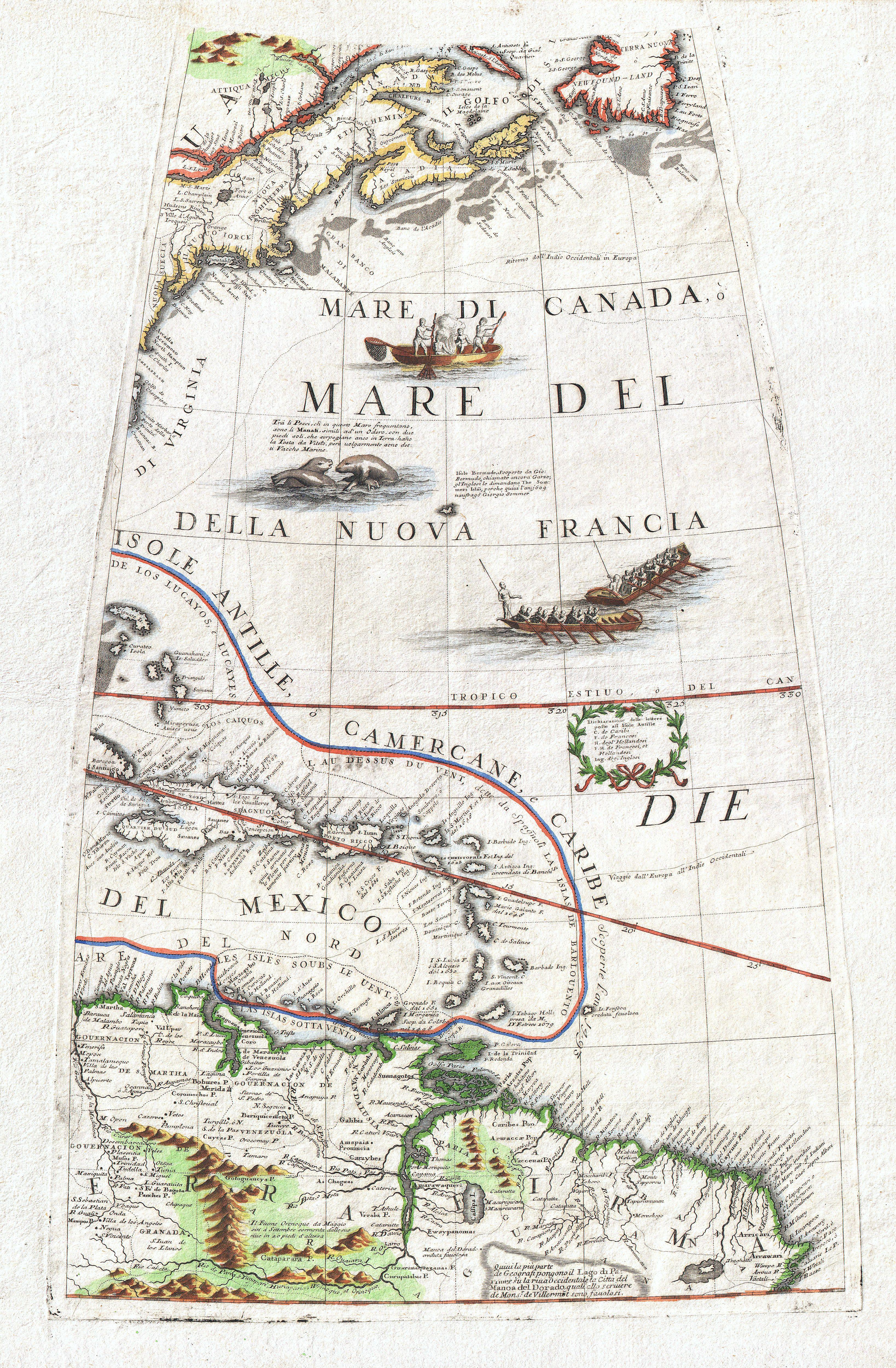
New England, the West Indies, Northeastern South America (Unitled Globe Gore). |
|||||||||||||||||||||||
| Description |
English: A fine example of Vincenzo Coronelli’s extremely rare 1688 globe gore of Eastern America. Covers from Newfoundland south along the New England and Virginia coastlines to the Bahamas (Gigante) and the West Indies, showing parts of Cuba and all of Hispaniola, Porto Rico and the Lesser Antilles, as well as the northern parts of South America from modern day Venezuela to the Orinoco Delta and the Guianas. As Royal Cartographer to King Louis XIV of France, Coronelli had access to the most recent cartographic records coming from the New World – particularly form the French occupied territories in North America and the West Indies. Advocating French control of much of North America, Coronelli limits New England (Nuoua Inghilterra) to the regions immediately surrounding Cape Cod and Boston Harbor. Similarly, New York (Nuoua Iorck) is confined to the coastal lands near New York City, Connecticut and Long Island. Though largely supplemented by the British by the time Coronelli drew this map, he recognizes Sweden’s claims to New Sweden (Nuoua Suecia) in the vicinity of Delaware Bay. The West Indies are drawn with considerable accuracy with notations for cities, ports, islands, and references to the powers that controlled them. Offers good though somewhat inaccurate detail of South America’s mountain and river systems, particularly the Orinoco. Additionally, this map also shows several important sailing routes including both northern and southern routes to Europe. Decorated by several vignettes including cod fishermen off the coast of New England, frolicking Mentees, and two rowboats plying the Atlantic. Also depicts many of the important cod fishing banks between Cape Cod and Newfoundland. This beautiful gore was originally drawn by Coronelli as part of his fantastic 42 inch “Terresterial Globe”. Several examples of this magnificent globe are prized today by institutional collections in Europe and America. Far rarer are the atlases that Coronelli published from his globe gores. The Libro Dei Globi , published in 1693 and again in 1701, is the first and likely the finest example of a world atlas composed entirely of globe gores. Only seven complete examples of this rare atlas are known to have survived to modern times. |
|||||||||||||||||||||||
| Date | 1688 (undated) | |||||||||||||||||||||||
| Dimensions | Height: 18.2 ″ (46.3 cm); Width: 11.5 ″ (29.2 cm) | |||||||||||||||||||||||
| Accession number |
Geographicus link: NEAmericaGore-coronelli-1688 |
|||||||||||||||||||||||
| Source/Photographer |
Coronelli, Vincento. Libro dei Globi, 1693 edition.
|
|||||||||||||||||||||||
| Permission (Reusing this file) |
|
|||||||||||||||||||||||

Public Domain
| EXIF data: | |
| File name | 1688_coronelli_globe_gore_map_of_ne_north_america__the_west_indies__and_ne_south_america___geographicus___neamericagore_coronelli_1688.jpg |
|---|---|
| Size, Mbytes | 4.90150390625 |
| Mime type | image/jpeg |
While the copyright and licensing information supplied for each photo is believed to be accurate, Free-Photos.biz does not provide any warranty regarding the copyright status or correctness of licensing terms. If you decide to reuse the images from Free-Photos.biz, you should verify the copyright status of each image just as you would when obtaining images from other sources.
The use of depictions of living or deceased persons may be restricted in some jurisdictions by laws regarding personality rights. Such images are exhibited at Free-Photos.biz as works of art that serve higher artistic interests.
PRIVACY POLICY
By registering your account and/or by subscribing to new and newly rated photographs you agree we may send you the links to photos and we may occasionally share other information with you.
We do NOT disclose your personal data.
