

Please login in order to download photos in full size
If you are not registered, please register for free: www.Free-Photos.biz/register
Please note to download premium images you also need to join as a free member..
You can also save the photos without the registration - but only in small and average sizes, and some of them will have the site's watermark. Please simply click your right mouse button and save the image.
Please login in order to like photos
If you are not registered, please register for free:
Sorry, non-members can download up to 1100 full-size photos per month.
It looks like you have used up your limit.
Free members can download an unlimited number of full-size photos - including the premium free photos.
Join as a member today for FREE! - and download the images without limitations:
www.Free-Photos.biz/membership.php
You can also save the images without the membership - but only in small and average sizes, and some of them may have the site's watermark. Please simply click your right mouse button and save the image.
|
This is a premium free photo
This photo was viewed times and was downloaded in full size 0 times.
This photo was liked 0 times


If you are a member, please login in order to see the source link of the above image.
| Artist | ||||||
| Title |
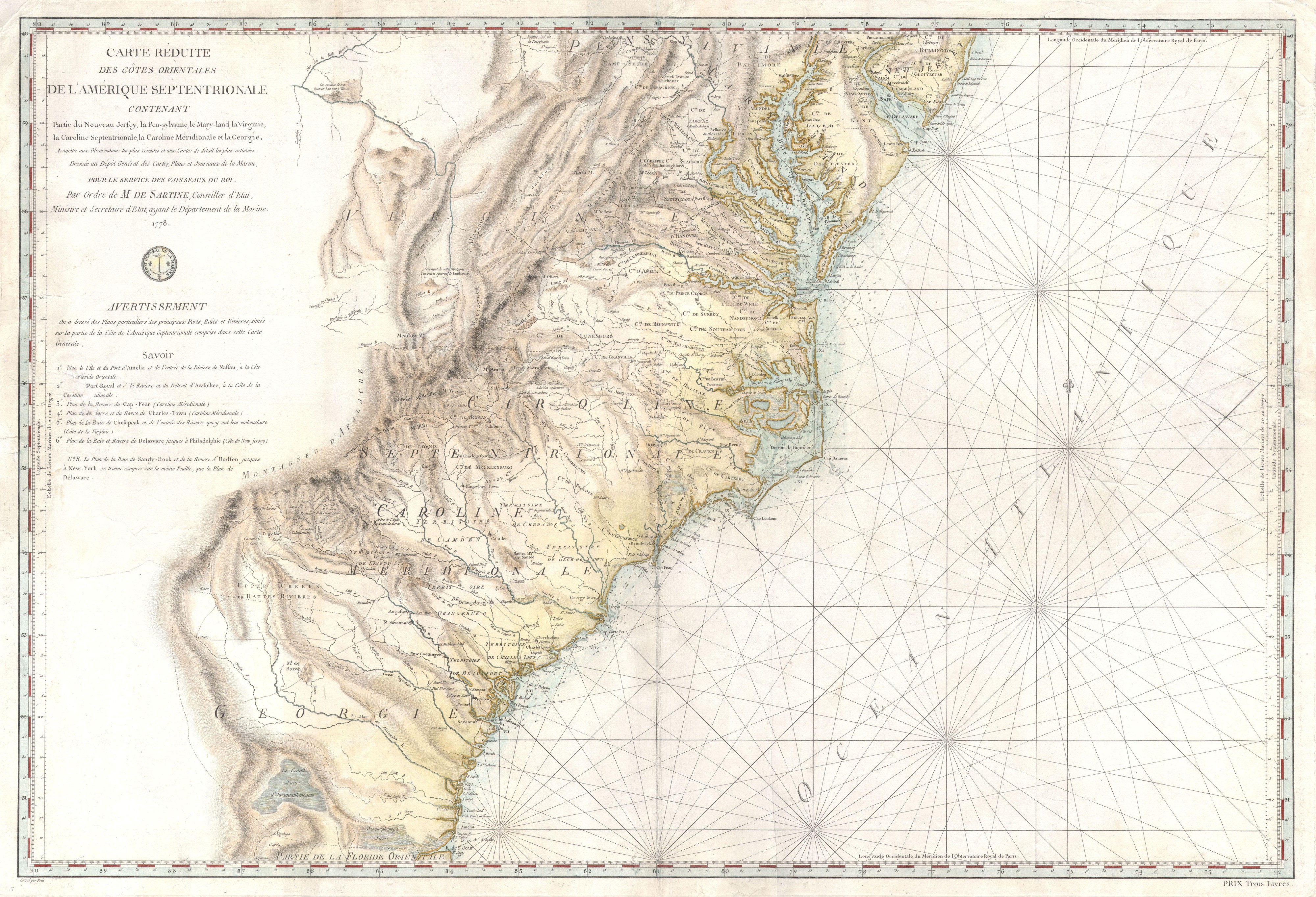
Carte Reduite Des Cotes Orientales De L'amerique Septentrionale Contenant Partie du Nouveau Jersey, la Pen-sylvanie, le Mary-land, la Virginie, la Caroline Septentrionale, la Caroline Meridionale et la Georgie, Assujettie aux Observations les plus recentes et aux Cartes de detail les plus estimées. Dressée au Dépôt Général des Cartes, Plans et Journaux de la Marine. Pour le Service des Vaisseaux Français Par Ordre de M. de Sartine, Conseiller d'Etat, Ministre et Secretaire d'Etat, ayant le Département de la Marine. 1778. |
|||||
| Description |
English: A rare and extraordinary map of considerable historic importance. This map, which covers from New Jersey and Pennsylvania southward through Maryland and Virginia, then along the Carolina coast to Georgia and Florida, was issued by the French “Depot General de la Marine” in 1778. Although ostensibly a nautical chart, this map features a magnificent wealth of inland detail as far west as the Appellation Mountains and the Ohio River. Around the time this map was issued the French had been dragged into the American Revolutionary War. As a government issue map, included in the extremely rare Neptune Americo-Septentrional, this map would have been carried by most French naval, merchant marine, and other military commanders. While the French contribution to the American Revolutionary War was primarily naval, the military nature of this map gives us some insight into the superb inland detail offered. We may safely surmise that such rich inland and topographic details would have been invaluable to any French forces that may have been grounded or forced to wage a land campaign. Details political and topographical features ranging from colonial borders to rivers and swamps, such as the Okefenokee in Georgia. Shows the American Indian holdings in western Georgia, the Carolinas and Virginia. The map also gives special attention to churches, missions and more specifically religious congregations, listing the Quakers, the “Assemblent les Non-confirmistes”, and others. The “Non-confirmistes” are a curious element of this map. Though to the Catholic French, this could have referred to Anglicans, Puritans, or any other Protestant group, the general location of the “Assemblent”, in western North Carolina, suggests the possibly that they were Franklinites. The coastline is dotted with innumerable detailed depth soundings. The location of the Catawba Indians Catawbaw Town is shown south of Charlotte. In Virginia, the town of York is noted on the York River, where we now recognize Yorktown. One can easily imagine that the French Admiral De Grasse consulting this map when, in 1781, his blockade of the York River forced the surrender of Cornwallis’ British forces at Yorktown, effectively ending the American Revolutionary War. This map was commissioned by Antoine de Sartine for inclusion in the Neptune Americo-Septentrional. It was engraved by Petit. Though his name does not appear on the map, the cartographic work behind this map is most likely the legacy of the late ingénieur hydrographe Jacques-Nicolas Bellin. Though dated 1778, this is mostly likely the second state of this rare map as is suggested by the removeal of Petit’s full title “Graveur du Roi et de la Marine” in the lower left hand corner and the addition of a price, “Pris Trois Livres” in the lower right. |
|||||
| Date | 1778 (dated) | |||||
| Dimensions | Height: 23 ″ (58.4 cm); Width: 34 ″ (86.3 cm) | |||||
| Accession number |
Geographicus link: Carolina-sartine-1778 |
|||||
| Source/Photographer |
Neptune Americo-Septentrional, 1778 edition.
|
|||||
| Permission (Reusing this file) |
|
|||||
Public Domain
| EXIF data: | |
| File name | 1778_sartine_map_of_georgia__north_carolina__south_carolina__virginia_and_maryland___geographicus___carolina_sartine_1778.jpg |
|---|---|
| Size, Mbytes | 4.016255859375 |
| Mime type | image/jpeg |
While the copyright and licensing information supplied for each photo is believed to be accurate, Free-Photos.biz does not provide any warranty regarding the copyright status or correctness of licensing terms. If you decide to reuse the images from Free-Photos.biz, you should verify the copyright status of each image just as you would when obtaining images from other sources.
The use of depictions of living or deceased persons may be restricted in some jurisdictions by laws regarding personality rights. Such images are exhibited at Free-Photos.biz as works of art that serve higher artistic interests.
PRIVACY POLICY
By registering your account and/or by subscribing to new and newly rated photographs you agree we may send you the links to photos and we may occasionally share other information with you.
We do NOT disclose your personal data.
