

Please login in order to download photos in full size
If you are not registered, please register for free: www.Free-Photos.biz/register
Please note to download premium images you also need to join as a free member..
You can also save the photos without the registration - but only in small and average sizes, and some of them will have the site's watermark. Please simply click your right mouse button and save the image.
Please login in order to like photos
If you are not registered, please register for free:
Sorry, non-members can download up to 1100 full-size photos per month.
It looks like you have used up your limit.
Free members can download an unlimited number of full-size photos - including the premium free photos.
Join as a member today for FREE! - and download the images without limitations:
www.Free-Photos.biz/membership.php
You can also save the images without the membership - but only in small and average sizes, and some of them may have the site's watermark. Please simply click your right mouse button and save the image.
|
This is a premium free photo
This photo was viewed 3 times and was downloaded in full size 0 times.
This photo was liked 0 times


Source page: |
http://commons.wikimedia.org/wiki/File:Rabe_Crater_topography_(14193085204).jpg |
|---|
.jpg)
| Description |
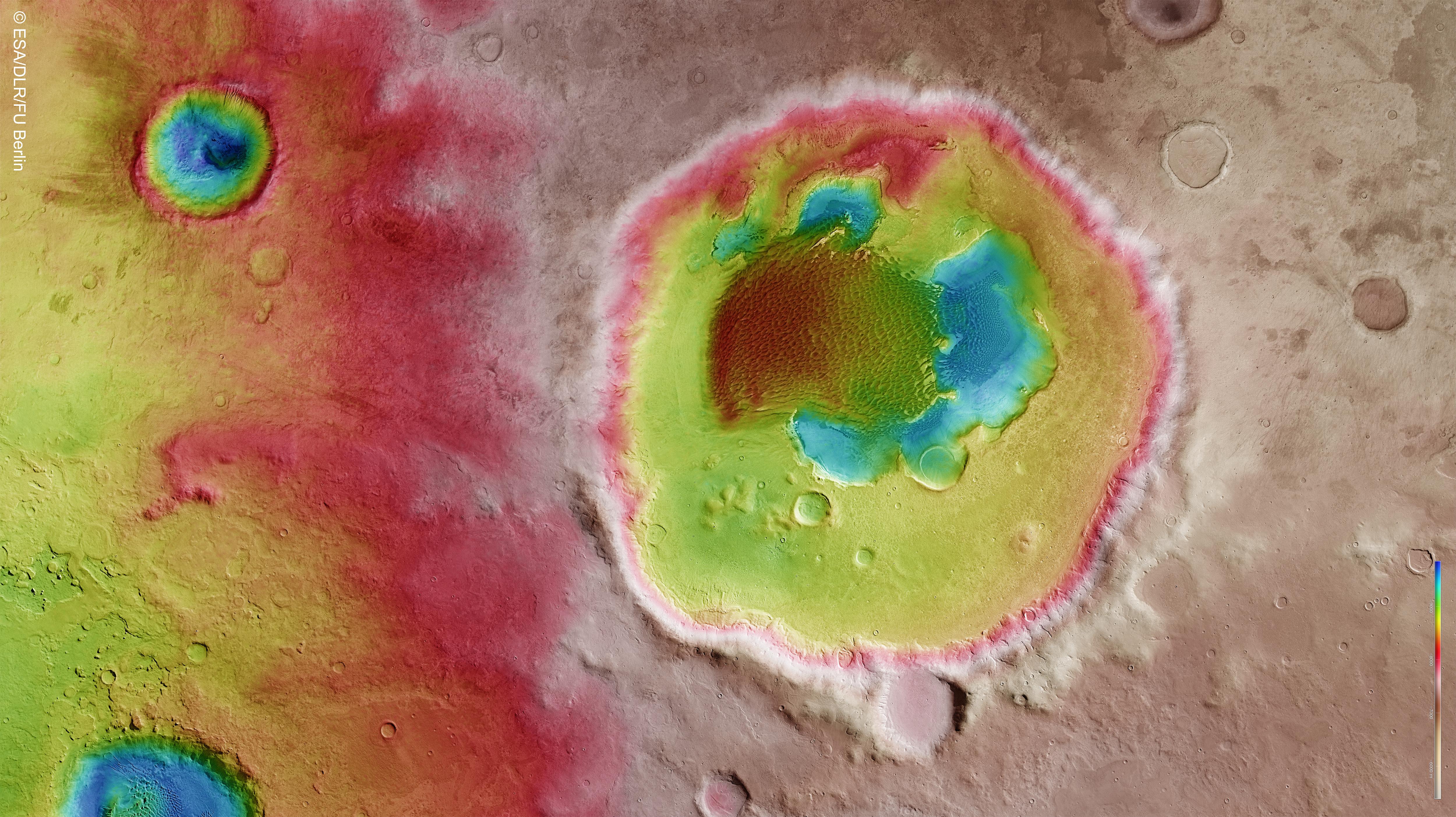
Colour-coded topography map of Rabe crater and its immediate surroundings. White and red show the highest terrains, while blue and purple show the deepest. The image is based on a digital terrain model of the region, from which the topography of the landscape has been derived. The image was created using data acquired with the High Resolution Stereo Camera on Mars Express on 7 December 2005 (orbit 2441) and 9 January 2014 (orbit 12736). The scene is located at 35°E/44°S, about 320 km west of the giant Hellas impact basin in the southern highlands of Mars. The image resolution is about 15 m per pixel. North is at right (a map). Credit: ESA/DLR/FU Berlin, CC BY-SA 3.0 IGO Copyright Notice: This work is licenced under the Creative Commons Attribution-ShareAlike 3.0 IGO (CC BY-SA 3.0 IGO) licence. The user is allowed to reproduce, distribute, adapt, translate and publicly perform this publication, without explicit permission, provided that the content is accompanied by an acknowledgement that the source is credited as 'ESA/DLR/FU Berlin’, a direct link to the licence text is provided and that it is clearly indicated if changes were made to the original content. Adaptation/translation/derivatives must be distributed under the same licence terms as this publication. To view a copy of this license, please visit creativecommons.org/licenses/by-sa/3.0/igo/ |
| Date | |
| Source | Rabe Crater topography |
| Author | European Space Agency |
Licensingedit
.jpg&action=edit§ion=1)
| This file is licensed under the Creative Commons Attribution-ShareAlike 3.0 IGO license. | ||
|
| This image was originally posted to Flickr by europeanspaceagency at https://flickr.com/photos/37472264@N04/14193085204. It was reviewed on by the FlickreviewR robot and was confirmed to be licensed under the terms of the cc-by-sa-2.0. |
| EXIF data: | |
| File name | rabe_crater_topography__14193085204_.jpg |
|---|---|
| Size, Mbytes | 2.4879345703125 |
| Mime type | image/jpeg |
While the copyright and licensing information supplied for each photo is believed to be accurate, Free-Photos.biz does not provide any warranty regarding the copyright status or correctness of licensing terms. If you decide to reuse the images from Free-Photos.biz, you should verify the copyright status of each image just as you would when obtaining images from other sources.
The use of depictions of living or deceased persons may be restricted in some jurisdictions by laws regarding personality rights. Such images are exhibited at Free-Photos.biz as works of art that serve higher artistic interests.
PRIVACY POLICY
By registering your account and/or by subscribing to new and newly rated photographs you agree we may send you the links to photos and we may occasionally share other information with you.
We do NOT disclose your personal data.
