

Please login in order to download photos in full size
If you are not registered, please register for free: www.Free-Photos.biz/register
Please note to download premium images you also need to join as a free member..
You can also save the photos without the registration - but only in small and average sizes, and some of them will have the site's watermark. Please simply click your right mouse button and save the image.
Please login in order to like photos
If you are not registered, please register for free:
Sorry, non-members can download up to 1100 full-size photos per month.
It looks like you have used up your limit.
Free members can download an unlimited number of full-size photos - including the premium free photos.
Join as a member today for FREE! - and download the images without limitations:
www.Free-Photos.biz/membership.php
You can also save the images without the membership - but only in small and average sizes, and some of them may have the site's watermark. Please simply click your right mouse button and save the image.
|
This is a premium free photo
This photo was viewed 92 times and was downloaded in full size 40 times.
This photo was liked 1 times


If you are a member, please login in order to see the source link of the above image.
Summaryedit
| Description |
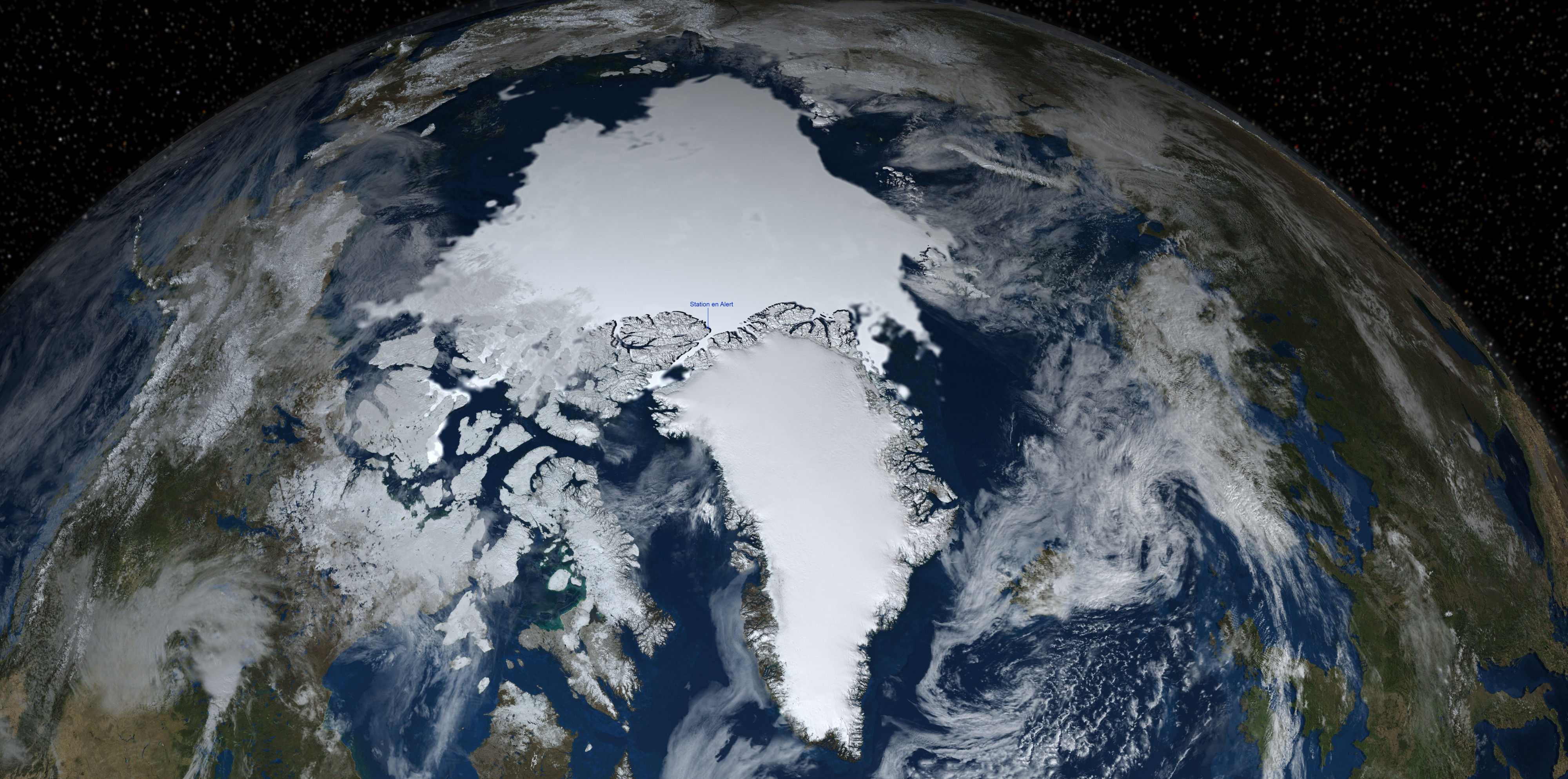
Français : Extension de la banquise au 15 septembre 2008 déterminé par le satellite AMSR-E. La terre montre la moyenne de la couverture neigeuse pour septembre 2004 (Blue Marble Next Generation). Les nuages sont obtenus par Blue Marble 2002 (Blue Marble:Clouds). Une partie de l'hémisphère nord de la Terre avec la banquise, nuage, étoile et localisation de la station météo en Alert
|
| Date | , 08:00:14 |
| Source | Commons : File:Earth's northern hemisphere with sea ice and clouds.jpg / La description et l'image est issue de https://svs.gsfc.nasa.gov/goto?3525 (TIFF image of the Earth composited over TIFF star background) |
| Author | NASA/Goddard Space Flight Center Scientific Visualization Studio |
Licensingedit
| This file is in the public domain because it was solely created by NASA. NASA copyright policy states that "NASA material is not protected by copyright unless noted". (See Template:PD-USGov, NASA copyright policy page or JPL Image Use Policy.) |
|
 |
Warnings:
|
Extension de la banquise au 15 septembre 2008 déterminé par le satellite AMSR-E. La terre montre la moyenne de la couverture neigeuse pour septembre 2004 (Blue Marble Next Generation). Les nuages sont obtenus par Blue Marble 2002 (Blue Marble:Clouds). Une partie de l'hémisphère nord de la Terre avec la banquise, nuage, étoile et localisation de la station météo en Alert
Public Domain
| EXIF data: | |
| File name | une_partie_de_l_ha_mispha_re_nord_de_la_terre_avec_la_banquise__nuage__a_toile_et_localisation_de_la_station_ma_ta_o_en_alert.jpg |
|---|---|
| Size, Mbytes | 6.501904296875 |
| Mime type | image/jpeg |
| Image resolution in width direction | 1 |
| Image resolution in height direction | 1 |
| Unit of X and Y resolution | 2 |
| Exif version | 0210 |
| Supported Flashpix version | 0100 |
| Color space information | 65535 |
| Software used | GIMP 2.8.2 |
While the copyright and licensing information supplied for each photo is believed to be accurate, Free-Photos.biz does not provide any warranty regarding the copyright status or correctness of licensing terms. If you decide to reuse the images from Free-Photos.biz, you should verify the copyright status of each image just as you would when obtaining images from other sources.
The use of depictions of living or deceased persons may be restricted in some jurisdictions by laws regarding personality rights. Such images are exhibited at Free-Photos.biz as works of art that serve higher artistic interests.
PRIVACY POLICY
By registering your account and/or by subscribing to new and newly rated photographs you agree we may send you the links to photos and we may occasionally share other information with you.
We do NOT disclose your personal data.
