

Please login in order to download photos in full size
If you are not registered, please register for free: www.Free-Photos.biz/register
Please note to download premium images you also need to join as a free member..
You can also save the photos without the registration - but only in small and average sizes, and some of them will have the site's watermark. Please simply click your right mouse button and save the image.
Please login in order to like photos
If you are not registered, please register for free:
Sorry, non-members can download up to 1100 full-size photos per month.
It looks like you have used up your limit.
Free members can download an unlimited number of full-size photos - including the premium free photos.
Join as a member today for FREE! - and download the images without limitations:
www.Free-Photos.biz/membership.php
You can also save the images without the membership - but only in small and average sizes, and some of them may have the site's watermark. Please simply click your right mouse button and save the image.
|
This is a premium free photo
This photo was viewed 4 times and was downloaded in full size 1 times.
This photo was liked 0 times


If you are a member, please login in order to see the source link of the above image.
Summaryedit
| Description |
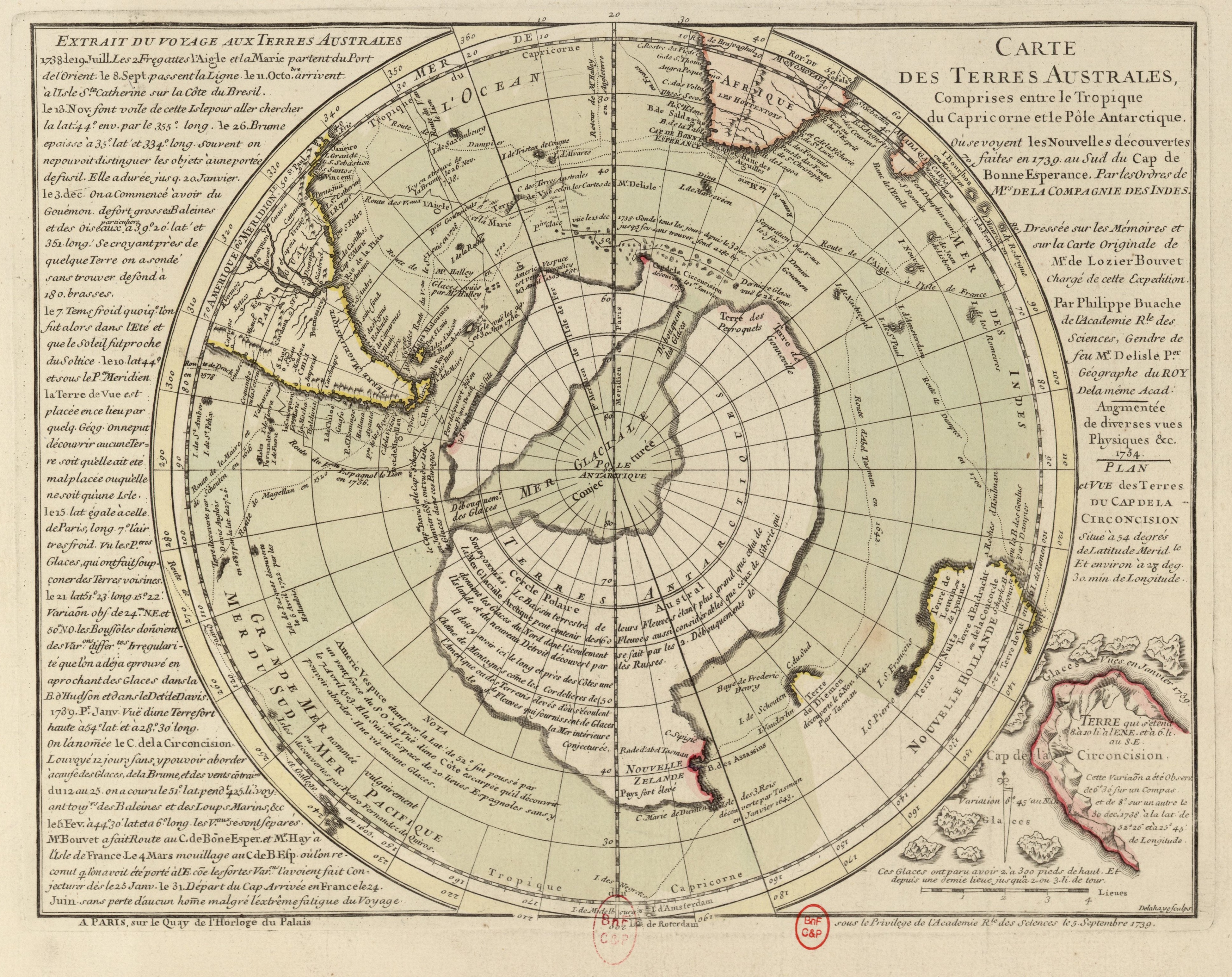
English: Map of the expedition of Jean-Baptiste Bouvet de Lozier, during which he discovered Bouvet Island in 1739. This map seems to be an improved second edition (published in 1754?) afer a first such map was published in 1739 immediatey after Bouvet's return to France. This 1739 map is also in Wikimedia Commons as: File:Antarctica, Bouvet Island, discovery map 1739.jpg . The French title of this new map reads: "Map of the southern lands between the Tropic of Capricorn and the Antarctic Pole, where one sees the New discoveries made in 1739 south of Cape of Good Hope by orders of the (French) East-India Company. Based on the journals and the original map of Mr de Lozier Bouvet, leader of this expedition. Extended with various Physical observations etc., 1754".
Nederlands: Kaart van het traject van de expeditie van Jean-Baptiste Bouvet de Lozier, waarbij deze in 1739 Bouvet ontdekte. Deze kaart (uit 1754?) lijkt een verbeterde uitgave te zijn van die welke in 1739 direct na terugkeer van de expeditie werd gemaakt en die ook op Wikimedia Commons beschikbaar is als: File:Antarctica, Bouvet Island, discovery map 1739.jpg. De Franse titel van deze nieuwe kaart luidt: "Kaart van de zuidelijke landen tussen de Steenbokskeerkring en de Zuidpool, waar men de Nieuwe ontdekkingen ziet, gedaan in 1739 ten zuiden van Kaap de Goede Hoop in opdracht van de (Franse) Oost-Indische Compagnie. Gebaseerd op het logboek en de originele kaart van de heer de Lozier Bouvet, leider van deze expeditie. Uitgebreid met diverse Fysieke waarnemingen etc. 1754."
Français : "Carte des Terres Australes comprises entre le Tropique du Capricorne et le Pôle Antarctique où se voyent les Nouvelles découvertes faites en 1739 au Sud du Cap de Bonne Espérance par les Ordres de Mrs de la Compagnie des Indes. Dressée sur les Mémoires et sur la Carte originale de Mr de Lozier Bouvet chargé de cette Expédition. Augmentée de diverses vues Physiques &c, 1754." (Cette carte paraît être une seconde edition de celle de 1739, qui est disponible en Wikimedia Commoms comme: File:Antarctica, Bouvet Island, discovery map 1739.jpg )
|
| Date | 1754 (1770?) |
| Source | Bibliothèque nationale de France |
| Author | Buache, Philippe (1700-1773, cartographer) + Delahaye, Jean-Baptiste (Graveur/Engraver) |
Bouvet is located at:
|
Camera location |
|
View this and other nearby images on: | (Info) |
|---|
Bibliographic references: Type : document cartographique,document cartographique manuscrit,image fixe; Langue : Français ; Format : 1 carte : tracés en coul. ; 41 x 48 cm; Droits : domaine public; Identifiant : ark:/12148/btv1b5970597m ; Source : Bibliothèque nationale de France, département Cartes et plans, GE SH 18 PF 1 DIV 0 P 21/2; Appartient à : Service hydrographique de la Marine; [Portefeuilles 1 et 1 bis du Service hydrographique de la marine (fonds ancien) consacrés aux mappemondes, cartes magnétiques, cartes polaires et planisphères] ; 21/2; Relation : https://catalogue.bnf.fr/ark:/12148/cb40592237k ; Provenance : bnf.fr
Licensingedit
{{PD-Art}} template without parameter: please specify why the underlying work is public domain in both the source country and the United States
(Usage: {{PD-Art|1=|deathyear=|country=|date=}}, where parameter #1 can be PD-old-auto, PD-old-auto-1923, PD-old-100 or similar) |
||||
Public Domain
| EXIF data: | |
| File name | antarctica__bouvet_island__discovery_map_1754.jpg |
|---|---|
| Size, Mbytes | 4.2581591796875 |
| Mime type | image/jpeg |
While the copyright and licensing information supplied for each photo is believed to be accurate, Free-Photos.biz does not provide any warranty regarding the copyright status or correctness of licensing terms. If you decide to reuse the images from Free-Photos.biz, you should verify the copyright status of each image just as you would when obtaining images from other sources.
The use of depictions of living or deceased persons may be restricted in some jurisdictions by laws regarding personality rights. Such images are exhibited at Free-Photos.biz as works of art that serve higher artistic interests.
PRIVACY POLICY
By registering your account and/or by subscribing to new and newly rated photographs you agree we may send you the links to photos and we may occasionally share other information with you.
We do NOT disclose your personal data.
