

Please login in order to download photos in full size
If you are not registered, please register for free: www.Free-Photos.biz/register
Please note to download premium images you also need to join as a free member..
You can also save the photos without the registration - but only in small and average sizes, and some of them will have the site's watermark. Please simply click your right mouse button and save the image.
Please login in order to like photos
If you are not registered, please register for free:
Sorry, non-members can download up to 1100 full-size photos per month.
It looks like you have used up your limit.
Free members can download an unlimited number of full-size photos - including the premium free photos.
Join as a member today for FREE! - and download the images without limitations:
www.Free-Photos.biz/membership.php
You can also save the images without the membership - but only in small and average sizes, and some of them may have the site's watermark. Please simply click your right mouse button and save the image.
|
This is a premium free photo
This photo was viewed 1 times and was downloaded in full size 0 times.
This photo was liked 0 times


If you are a member, please login in order to see the source link of the above image.
| Artist | https://www.geographicus.com/mm5/cartographers/homannheirs.txt | |||||
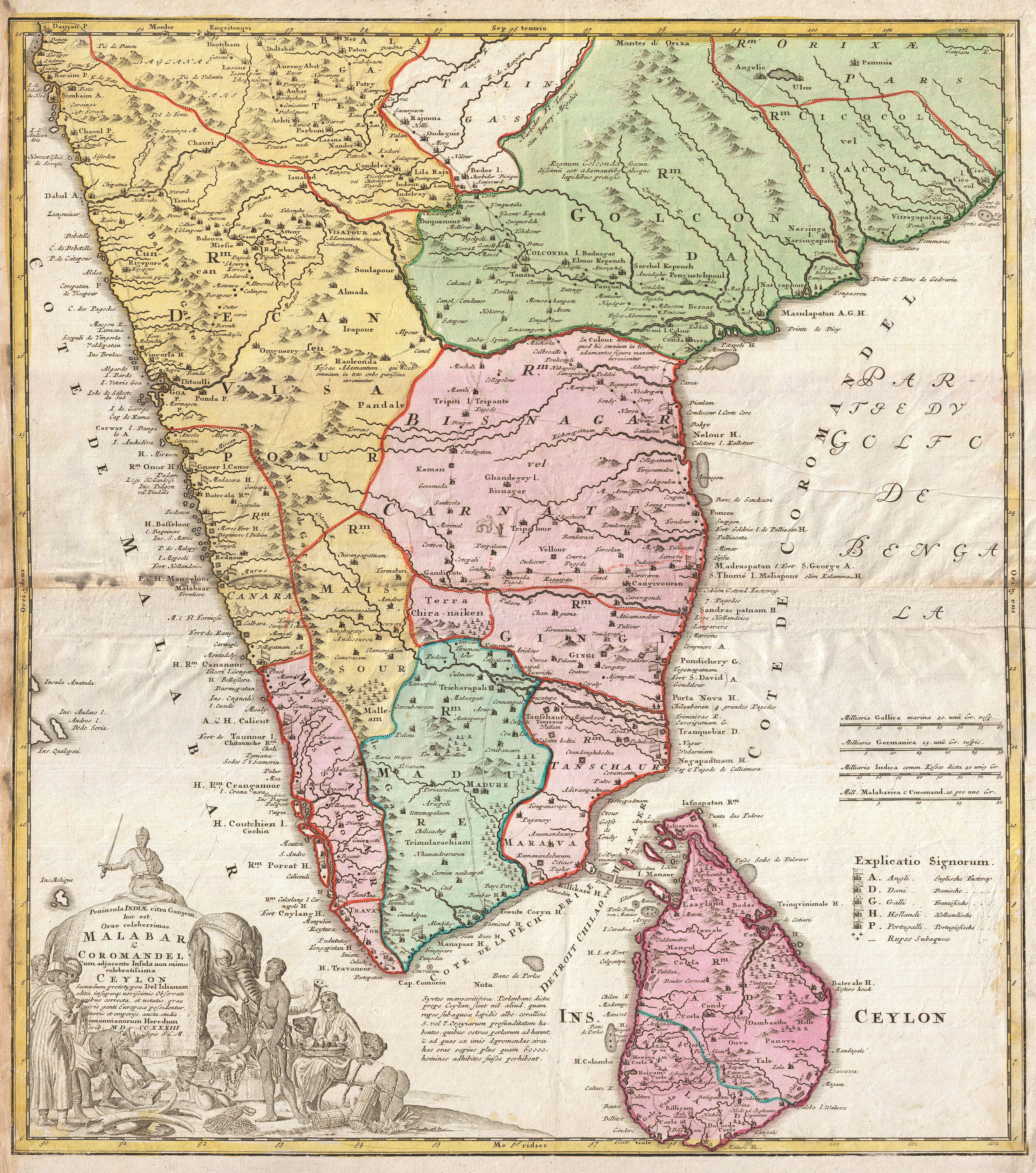
| Title | Peninsula Indiae citra Gangem, hoc est, Orae celeberrimae Malabar & Coromandel Cum adjacent Insula non minus celebratissima Ceylon Secundum prototypon Del' Islianum edita, insuperqs novissimis Observationibus correcta, et notates, quae cuivis genti Europaeae possidentur, terries et emporys, aucta, studio. Homannianorum Heredum Noriv. MDCCXXXIII Cum Privilegio S.C.M. | |||||
| Description |
English: A rare map of India and Ceylon issued in 1733 by the Homann Heirs. Covers the subcontinent roughly from Bombay south to Cape Comorin and includes all of Ceylon (Sri Lanka). Homan offers good detail along the coast naming numerous ports and, where appropriate, appending either an English, French, Danish, Dutch or Portuguese flag to indicate the European power laying claim to that port. The interior is more vague, though many of the major caravan routes are noted, if only speculatively. There are numerous annotations in Latin throughout. Homann also identifies various battle sites associated with the southward progress of the Mughal Empire in 1707. When Homann drew this map, only Madras, Malabar, Ceylon, and the European ports remained independent of Mughal control. A large title cartouche depicting Indian traders and an elephant appears in the lower left quadrant.
|
|||||
| Date | 1733 (dated) | |||||
| Dimensions | Height: 22 in (55.9 cm). Width: 19 in (48.3 cm). | |||||
| Accession number | Geographicus code: India-homannheirs-1733 | |||||
| Source/Photographer |
Seutter, Matthaeus, Atlantis Geographicus Maior, [Grosser Atlas], Pts. 1 and 2, Nuremberg: Homann Erben, 1734-1781.
|
|||||
| Permission (Reusing this file) |
|
|||||
Public Domain
| EXIF data: | |
| File name | 1733_homann_heirs_map_of_india_-_geographicus_-_india-homannheirs-1733.jpg |
|---|---|
| Size, Mbytes | 5.5421279296875 |
| Mime type | image/jpeg |
While the copyright and licensing information supplied for each photo is believed to be accurate, Free-Photos.biz does not provide any warranty regarding the copyright status or correctness of licensing terms. If you decide to reuse the images from Free-Photos.biz, you should verify the copyright status of each image just as you would when obtaining images from other sources.
The use of depictions of living or deceased persons may be restricted in some jurisdictions by laws regarding personality rights. Such images are exhibited at Free-Photos.biz as works of art that serve higher artistic interests.
PRIVACY POLICY
By registering your account and/or by subscribing to new and newly rated photographs you agree we may send you the links to photos and we may occasionally share other information with you.
We do NOT disclose your personal data.
