

Please login in order to download photos in full size
If you are not registered, please register for free: www.Free-Photos.biz/register
Please note to download premium images you also need to join as a free member..
You can also save the photos without the registration - but only in small and average sizes, and some of them will have the site's watermark. Please simply click your right mouse button and save the image.
Please login in order to like photos
If you are not registered, please register for free:
Sorry, non-members can download up to 1100 full-size photos per month.
It looks like you have used up your limit.
Free members can download an unlimited number of full-size photos - including the premium free photos.
Join as a member today for FREE! - and download the images without limitations:
www.Free-Photos.biz/membership.php
You can also save the images without the membership - but only in small and average sizes, and some of them may have the site's watermark. Please simply click your right mouse button and save the image.
|
This is a premium free photo
This photo was viewed times and was downloaded in full size 0 times.
This photo was liked 0 times


If you are a member, please login in order to see the source link of the above image.
| Artist |
|
|||||||||||||||||||
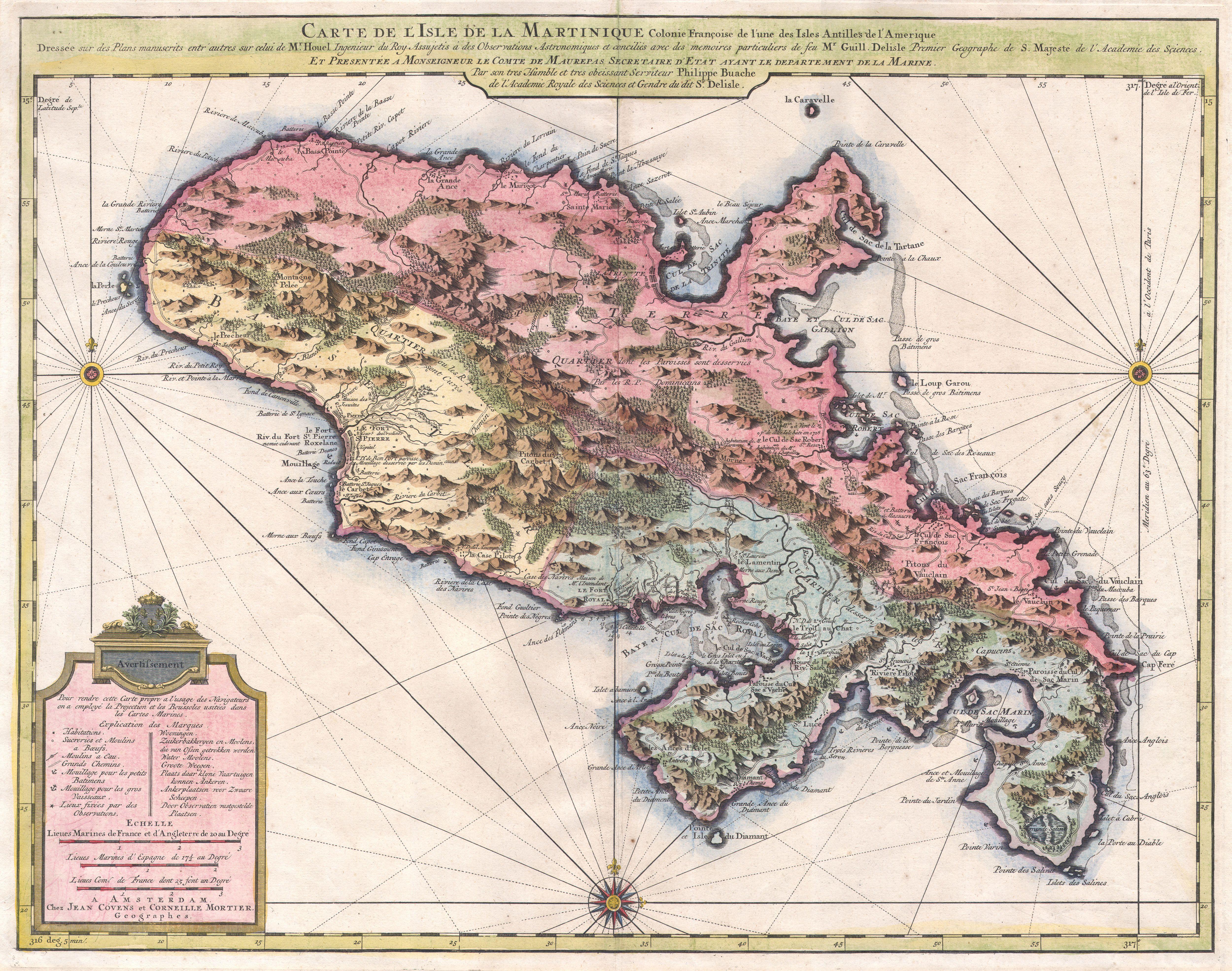
| Title | Carte de l'Isle de la Martinique, colonie francoise de l'une des Isles Antilles de l'Amerique. Dressee sur des plans manuscrits entr'autres sur celui de Mr. Houel, Ingenieur du Roy, assujetis a des observations astonomiques et concilies avec des memoires particuliers de feu Mr. Guill. Delisle, Premier Geographe de S. Majeste de l'Academie des Sciences. Et presentee a Monseigneur le Comte de Maurepas, Secretaire d'Etat ayant le departement de la Marine par ... Philippe Buache de l'Academie Royale des Sciences et Gendre du dit Sr. Delisle. A Amsterdam, Chez Jean Covens et Corneille Mortier, Geographes. | |||||||||||||||||||
| Description |
English: A beautiful example of Covens & Mortier’s 1742 map of the French colony of Martinique in the West Indies. Depicts the Island of Martinique divided into three sections, two in the south and one in the north. Includes both political and topographical information. Beautifully hand colored. Based upon the work of Guillaume DE L'ISLE (1675-1726) and Phillippe BUACHE (1700-1773). Prepared for the 1742 issue of Covens and Mortier’s Atlas Nouveau .
|
|||||||||||||||||||
| Date | c. 1742 (undated) | |||||||||||||||||||
| Dimensions | Height: 18.5 in (47 cm). Width: 23.5 in (59.7 cm). | |||||||||||||||||||
| Accession number | Geographicus code: Martinique-covensmortier-1742 | |||||||||||||||||||
| Source/Photographer |
|
|||||||||||||||||||
| Permission (Reusing this file) |
|
|||||||||||||||||||
Public Domain
| EXIF data: | |
| File name | 1742_covens_and_mortier_map_of_martinique_-_geographicus_-_martinique-covensmortier-1742.jpg |
|---|---|
| Size, Mbytes | 4.473884765625 |
| Mime type | image/jpeg |
While the copyright and licensing information supplied for each photo is believed to be accurate, Free-Photos.biz does not provide any warranty regarding the copyright status or correctness of licensing terms. If you decide to reuse the images from Free-Photos.biz, you should verify the copyright status of each image just as you would when obtaining images from other sources.
The use of depictions of living or deceased persons may be restricted in some jurisdictions by laws regarding personality rights. Such images are exhibited at Free-Photos.biz as works of art that serve higher artistic interests.
PRIVACY POLICY
By registering your account and/or by subscribing to new and newly rated photographs you agree we may send you the links to photos and we may occasionally share other information with you.
We do NOT disclose your personal data.
